![](/images/other/stat-length.png)
![Tour Mountainbike Saint-Just-Saint-Rambert - Du Barrage de Villerest au Barrage de Grangent en 10 boucles / Boucle N° 10 : Pont de Saint-Just-Saint-Rambert - Barrage de Grangent - Photo](https://media.geolcdn.com/t/1900/400/ext.pjpeg?maxdim=2&url=https%3A%2F%2Fservices.sitytrail.com%2FGeolivesWS%2FDownloadMedia.ashx%3FTrailID%3D316888%26Media%3D15971_6.jpg)
Du Barrage de Villerest au Barrage de Grangent en 10 boucles / Boucle N° 10 : Pont de Saint-Just-Saint-Rambert - Barrage de Grangent
tracegps
Benutzer
![Länge](/images/other/stat-length.png)
![Maximale Höhe](https://static1.geolcdn.com/siteimages/upload/files/1508320355ic_sort_altitude_max_24dp.png)
![Positive Höhendifferenz](https://static1.geolcdn.com/siteimages/upload/files/1508320355ic_sort_den_pos_24dp.png)
![Km-Effort](/images/other/stat-length.png)
![Min. Höhe](https://static1.geolcdn.com/siteimages/upload/files/1508320355ic_sort_altitude_min_24dp.png)
![Negative Höhendifferenz](https://static1.geolcdn.com/siteimages/upload/files/1508320355ic_sort_den_neg_24dp.png)
![Boucle](https://static1.geolcdn.com/siteimages/upload/files/16400158638029165_repeat_loop_refresh_sync_direction_icon.png)
![Mountainbike](https://static1.geolcdn.com/sitytour/trail-icons/202.png)
2h30
Schwierigkeit : Sehr schwierig
![Scannen Sie diesen QR-Code, um die Tour in der SityTrail-Anwendung zu öffnen](https://capi.geolives.com/qq0zvz2zws4bq2lad0pu/sitytour/trails/316888/qr.png?size=200)
Kostenlosegpshiking-Anwendung
Über SityTrail
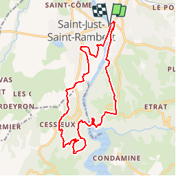
Tour Mountainbike von 17,7 km verfügbar auf Auvergne-Rhone-Alpen, Loire, Saint-Just-Saint-Rambert. Diese Tour wird von tracegps vorgeschlagen.
Beschreibung
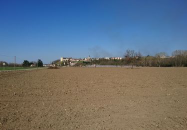
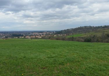
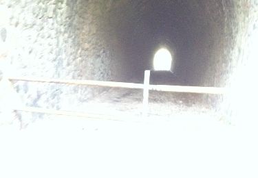
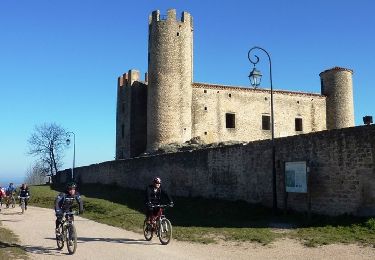
Parking et départ en contrebas du pont de Saint-Just-Saint-Rambert. Franchissant la Loire par le pont de Saint-Just-Saint-Rambert et par le Barrage de Grangent, ce circuit fait découvrir les rives de Loire est ses restaurants gastronomiques au bord du fleuve, une vue remarquable sur le port de Saint-Victor-sur-Loire, le château d’Essalois, le barrage de Grangent, les belvédères sur le barrage et l’ile de Grangent avec son château (privé). Le parcours débute et se termine par une portion roulante, mais il s’avère beaucoup plus technique de part et d’autre du barrage de Grangent avec un terrain plus accidenté voire cassant avec du rocher et de la piste pierreuse. Les paysages sont extraordinaires. A contempler sans modération…
Ort
Kommentare
Touren in der Umgebung
![Tour Wandern Chambles - Boucle de Cessieux - Photo](https://media.geolcdn.com/t/375/260/97d1920a-87e2-4c20-83ee-2ac6e2b239bd.jpg&format=jpg&maxdim=2)
![Wandern Wandern](https://static1.geolcdn.com/sitytour/trail-icons/101.png)
Wandern
![](/images/other/stat-length.png)
![](https://static1.geolcdn.com/siteimages/upload/files/16400158638029165_repeat_loop_refresh_sync_direction_icon.png)
![Tour Wandern La Fouillouse - Randonnée au dessus de La Fouillouse - Photo](https://media.geolcdn.com/t/375/260/89b3b03f-398e-4563-a0ed-cff73b535f6c.jpg&format=jpg&maxdim=2)
![Wandern Wandern](https://static1.geolcdn.com/sitytour/trail-icons/101.png)
Wandern
![](/images/other/stat-length.png)
![](https://static1.geolcdn.com/siteimages/upload/files/16400158638029165_repeat_loop_refresh_sync_direction_icon.png)
![Tour Mountainbike Saint-Just-Saint-Rambert - TBG - Photo](https://media.geolcdn.com/t/375/260/ext.jpg?maxdim=2&url=https%3A%2F%2Fstatic1.geolcdn.com%2Fsiteimages%2Fupload%2Ffiles%2F1524743154velo.jpg)
![Mountainbike Mountainbike](https://static1.geolcdn.com/sitytour/trail-icons/202.png)
Mountainbike
![](/images/other/stat-length.png)
![](https://static1.geolcdn.com/siteimages/upload/files/16400158638029165_repeat_loop_refresh_sync_direction_icon.png)
![Tour Wandern Andrézieux-Bouthéon - autour de Boutheon - Photo](https://media.geolcdn.com/t/375/260/2650ae89-7750-43af-bfc7-bc43f795b3df.jpg&format=jpg&maxdim=2)
![Wandern Wandern](https://static1.geolcdn.com/sitytour/trail-icons/101.png)
Wandern
![](/images/other/stat-length.png)
![](https://static1.geolcdn.com/siteimages/upload/files/16400158638029165_repeat_loop_refresh_sync_direction_icon.png)
![Tour Wandern Saint-Just-Saint-Rambert - les rives de la loire - Photo](https://media.geolcdn.com/t/375/260/ext.jpg?maxdim=2&url=https%3A%2F%2Fservices.sitytrail.com%2FGeolivesWS%2FDownloadMedia.ashx%3FTrailID%3D548506%26Media%3Dfix__20160403113644.jpg)
![Wandern Wandern](https://static1.geolcdn.com/sitytour/trail-icons/101.png)
Wandern
![](/images/other/stat-length.png)
![](https://static1.geolcdn.com/siteimages/upload/files/16400158638029165_repeat_loop_refresh_sync_direction_icon.png)
![Tour Wandern Saint-Just-Saint-Rambert - Barrage de Grangent - Photo](https://media.geolcdn.com/t/375/260/ext.jpg?maxdim=2&url=https%3A%2F%2Fservices.sitytrail.com%2FGeolivesWS%2FDownloadMedia.ashx%3FTrailID%3D369346%26Media%3D20140923161558.jpg)
![Wandern Wandern](https://static1.geolcdn.com/sitytour/trail-icons/101.png)
Wandern
![](/images/other/stat-length.png)
![](https://static1.geolcdn.com/siteimages/upload/files/16400158638029165_repeat_loop_refresh_sync_direction_icon.png)
![Tour Mountainbike Andrézieux-Bouthéon - 14ème Envolée Verte (2014-VTT-60 km) - Andrézieux-Bouthéon - Photo](https://media.geolcdn.com/t/375/260/ext.jpg?maxdim=2&url=https%3A%2F%2Fservices.sitytrail.com%2FGeolivesWS%2FDownloadMedia.ashx%3FTrailID%3D317644%26Media%3D16917_5.jpg)
![Mountainbike Mountainbike](https://static1.geolcdn.com/sitytour/trail-icons/202.png)
Mountainbike
![](/images/other/stat-length.png)
![](https://static1.geolcdn.com/siteimages/upload/files/16400158638029165_repeat_loop_refresh_sync_direction_icon.png)
![Tour Mountainbike Saint-Cyprien - Du Barrage de Villerest au Barrage de Grangent en 10 boucles / Boucle N° 09 : Pont d'Andrézieux - Pont de Saint-Just-Saint-Rambert - Photo](https://media.geolcdn.com/t/375/260/ext.jpg?maxdim=2&url=https%3A%2F%2Fservices.sitytrail.com%2FGeolivesWS%2FDownloadMedia.ashx%3FTrailID%3D316887%26Media%3D15970_6.jpg)
![Mountainbike Mountainbike](https://static1.geolcdn.com/sitytour/trail-icons/202.png)
Mountainbike
![](/images/other/stat-length.png)
![](https://static1.geolcdn.com/siteimages/upload/files/16400158638029165_repeat_loop_refresh_sync_direction_icon.png)
![Tour Mountainbike Andrézieux-Bouthéon - 13ème Envolée Verte (2013-VTT-46 km) - Andrézieux-Bouthéon - Photo](https://media.geolcdn.com/t/375/260/ext.jpg?maxdim=2&url=https%3A%2F%2Fservices.sitytrail.com%2FGeolivesWS%2FDownloadMedia.ashx%3FTrailID%3D191493%26Media%3D15085_6.jpg)
![Mountainbike Mountainbike](https://static1.geolcdn.com/sitytour/trail-icons/202.png)
Mountainbike
![](/images/other/stat-length.png)
![](https://static1.geolcdn.com/siteimages/upload/files/16400158638029165_repeat_loop_refresh_sync_direction_icon.png)