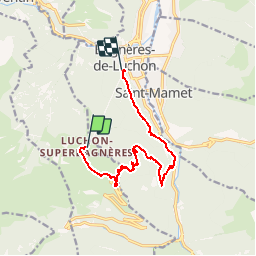
![](/images/other/stat-length.png)
![Tour Mountainbike Saint-Aventin - Luchon Kbour - Photo](https://media.geolcdn.com/t/1900/400/ext.pjpeg?maxdim=2&url=https%3A%2F%2Fservices.sitytrail.com%2FGeolivesWS%2FDownloadMedia.ashx%3FTrailID%3D316870%26Media%3D15951_6.jpg)
Luchon Kbour
tracegps
Benutzer
![Länge](/images/other/stat-length.png)
![Maximale Höhe](https://static1.geolcdn.com/siteimages/upload/files/1508320355ic_sort_altitude_max_24dp.png)
![Positive Höhendifferenz](https://static1.geolcdn.com/siteimages/upload/files/1508320355ic_sort_den_pos_24dp.png)
![Km-Effort](/images/other/stat-length.png)
![Min. Höhe](https://static1.geolcdn.com/siteimages/upload/files/1508320355ic_sort_altitude_min_24dp.png)
![Negative Höhendifferenz](https://static1.geolcdn.com/siteimages/upload/files/1508320355ic_sort_den_neg_24dp.png)
![Boucle](https://static1.geolcdn.com/siteimages/upload/files/16400158638029165_repeat_loop_refresh_sync_direction_icon.png)
![Mountainbike](https://static1.geolcdn.com/sitytour/trail-icons/202.png)
1h00
Schwierigkeit : Sehr schwierig
![Scannen Sie diesen QR-Code, um die Tour in der SityTrail-Anwendung zu öffnen](https://capi.geolives.com/qq0zvz2zws4bq2lad0pu/sitytour/trails/316870/qr.png?size=200)
Kostenlosegpshiking-Anwendung
Über SityTrail
Tour Mountainbike von 11 km verfügbar auf Okzitanien, Haute-Garonne, Saint-Aventin. Diese Tour wird von tracegps vorgeschlagen.
Beschreibung
Nouveau tracé de la Kbour (provisoire) après les dégâts du mois de juin 2013; le balisage a été bien refait et l'itinéraire modifié. J'ai ajouté en bas un retour en forêt avec 100m de remontées et quelques poussages pour arriver juste au départ des œufs sans passer par du goudron, qui plus est un jour de fête des fleurs... N'étant pas adepte du VTT de descente mais de montagne, je ne peux juger du niveau mais quelques passages se font à pied.
Ort
Kommentare
Touren in der Umgebung
![Tour Schneeschuhwandern Juzet-de-Luchon - JUZET - PAS DE LA COMBE (LABACH) - Photo](https://media.geolcdn.com/t/375/260/ext.jpg?maxdim=2&url=https%3A%2F%2Fservices.sitytrail.com%2FGeolivesWS%2FDownloadMedia.ashx%3FTrailID%3D689507%26Media%3Dfix__20170125152906.jpg)
![Schneeschuhwandern Schneeschuhwandern](https://static1.geolcdn.com/sitytour/trail-icons/504.png)
Schneeschuhwandern
![](/images/other/stat-length.png)
![](https://static1.geolcdn.com/siteimages/upload/files/16400158638029165_repeat_loop_refresh_sync_direction_icon.png)
![Tour Wandern Saint-Mamet - Fonds de Burbe - Saint Mamet - Photo](https://media.geolcdn.com/t/375/260/ext.jpg?maxdim=2&url=https%3A%2F%2Fservices.sitytrail.com%2FGeolivesWS%2FDownloadMedia.ashx%3FTrailID%3D317900%26Media%3D17313_6.jpg)
![Wandern Wandern](https://static1.geolcdn.com/sitytour/trail-icons/101.png)
Wandern
![](/images/other/stat-length.png)
![](https://static1.geolcdn.com/siteimages/upload/files/16400158638029165_repeat_loop_refresh_sync_direction_icon.png)
![Tour Zu Fuß Castillon-de-Larboust - Lac Vert, Boucle par l'Est - Photo](https://media.geolcdn.com/t/375/260/1cb240b3-a0f5-41eb-84f2-0d4dbcde9df6.jpeg&format=jpg&maxdim=2)
![Zu Fuß Zu Fuß](https://static1.geolcdn.com/sitytour/trail-icons/100.png)
Zu Fuß
![](/images/other/stat-length.png)
![](https://static1.geolcdn.com/siteimages/upload/files/16400158638029165_repeat_loop_refresh_sync_direction_icon.png)
![Tour Wandern Bagnères-de-Luchon - GR 10 - 3 - Photo](https://media.geolcdn.com/t/375/260/ext.jpg?maxdim=2&url=https%3A%2F%2Fstatic1.geolcdn.com%2Fsiteimages%2Fupload%2Ffiles%2F1553511878bg_sport_marche.png)
![Wandern Wandern](https://static1.geolcdn.com/sitytour/trail-icons/101.png)
Wandern
![](/images/other/stat-length.png)
![](https://static1.geolcdn.com/siteimages/upload/files/16400158638029165_repeat_loop_refresh_sync_direction_icon.png)
![Tour Wandern Bagnères-de-Luchon - Luchon via Saint Mamet - Photo](https://media.geolcdn.com/t/375/260/14945a1e-90fc-4d0d-9f7d-654cdbb4ea1f.jpg&format=jpg&maxdim=2)
![Wandern Wandern](https://static1.geolcdn.com/sitytour/trail-icons/101.png)
Wandern
![](/images/other/stat-length.png)
![](https://static1.geolcdn.com/siteimages/upload/files/16400158638029165_repeat_loop_refresh_sync_direction_icon.png)
![Tour Wandern Castillon-de-Larboust - lac Charles, lac bleu, lac vert vallée du Lys - Photo](https://media.geolcdn.com/t/375/260/1f63b39d-fa62-49e6-8fc8-727821f2e8d9.jpg&format=jpg&maxdim=2)
![Wandern Wandern](https://static1.geolcdn.com/sitytour/trail-icons/101.png)
Wandern
![](/images/other/stat-length.png)
![](https://static1.geolcdn.com/siteimages/upload/files/16400158638029165_repeat_loop_refresh_sync_direction_icon.png)
![Tour Wandern Sode - cabane de Plan Pouné, par refuge de Cualot - Photo](https://media.geolcdn.com/t/375/260/36e8fbb1-a132-4062-9b5e-14952719d757.jpg&format=jpg&maxdim=2)
![Wandern Wandern](https://static1.geolcdn.com/sitytour/trail-icons/101.png)
Wandern
![](/images/other/stat-length.png)
![](https://static1.geolcdn.com/siteimages/upload/files/16400158638029165_repeat_loop_refresh_sync_direction_icon.png)
![Tour Wandern Saint-Aventin - Cabane de Courreau en boucle depuis St Aventin - Photo](https://media.geolcdn.com/t/375/260/b7635b43-28f6-485c-bbc3-3b8695853635.jpg&format=jpg&maxdim=2)
![Wandern Wandern](https://static1.geolcdn.com/sitytour/trail-icons/101.png)
Wandern
![](/images/other/stat-length.png)
![](https://static1.geolcdn.com/siteimages/upload/files/16400158638029165_repeat_loop_refresh_sync_direction_icon.png)
![Tour Wandern Castillon-de-Larboust - Cabane de la Coume - Photo](https://media.geolcdn.com/t/375/260/c366e837-82a2-4e59-9c0c-9644aad8d00b.jpg&format=jpg&maxdim=2)
![Wandern Wandern](https://static1.geolcdn.com/sitytour/trail-icons/101.png)
Wandern
![](/images/other/stat-length.png)
![](https://static1.geolcdn.com/siteimages/upload/files/16400158638029165_repeat_loop_refresh_sync_direction_icon.png)
belle piste, très raide et technique, j'ai roulé sur le mouillé et a eu quelques moments de panique dans la section du milieu, au sec ce serait tres difficile, mieux d'éviter sous la pluie