![](/images/other/stat-length.png)
![Tour Wandern Gavarnie-Gèdre - Le Pic de la Gela - Gèdre - Photo](https://media.geolcdn.com/t/1900/400/ext.pjpeg?maxdim=2&url=https%3A%2F%2Fservices.sitytrail.com%2FGeolivesWS%2FDownloadMedia.ashx%3FTrailID%3D316845%26Media%3D15911_6.jpg)
Le Pic de la Gela - Gèdre
tracegps
Benutzer
![Länge](/images/other/stat-length.png)
![Maximale Höhe](https://static1.geolcdn.com/siteimages/upload/files/1508320355ic_sort_altitude_max_24dp.png)
![Positive Höhendifferenz](https://static1.geolcdn.com/siteimages/upload/files/1508320355ic_sort_den_pos_24dp.png)
![Km-Effort](/images/other/stat-length.png)
![Min. Höhe](https://static1.geolcdn.com/siteimages/upload/files/1508320355ic_sort_altitude_min_24dp.png)
![Negative Höhendifferenz](https://static1.geolcdn.com/siteimages/upload/files/1508320355ic_sort_den_neg_24dp.png)
![Boucle](https://static1.geolcdn.com/siteimages/upload/files/16400158638029165_repeat_loop_refresh_sync_direction_icon.png)
![Wandern](https://static1.geolcdn.com/sitytour/trail-icons/101.png)
8h30
Schwierigkeit : Schwierig
![Scannen Sie diesen QR-Code, um die Tour in der SityTrail-Anwendung zu öffnen](https://capi.geolives.com/qq0zvz2zws4bq2lad0pu/sitytour/trails/316845/qr.png?size=200)
Kostenlosegpshiking-Anwendung
Über SityTrail
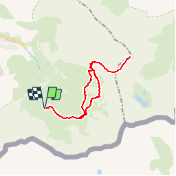
Tour Wandern von 13,8 km verfügbar auf Okzitanien, Hautes-Pyrénées, Gavarnie-Gèdre. Diese Tour wird von tracegps vorgeschlagen.
Beschreibung
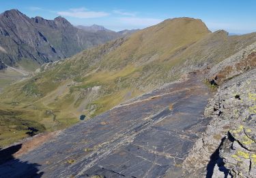
Au départ du parking du cirque de Troumouse, l’itinéraire en aller-retour contourne les lacs des Aires, et après avoir atteint les environs de la cabane des Aires, s’élève sur la paroi relativement raide mais assez facile pour atteindre le col de la Sède. Puis il emprunte une ligne de crête débonnaire jusqu’au flanc Nord du Pic de Gerbats. De là, un pierrier permet de rejoindre la ligne de crête au Nord-Est de ce Pic. Enfin, après le col de la Géla, la montée finale vers le Pic de la Géla est cairnée et ne présente pratiquement pas de difficultés, malgré son aspect. Superbe panorama depuis le sommet, avec notamment les lacs de Barroude, le Mont Perdu, le Vignemale…
Ort
Kommentare
Touren in der Umgebung
![Tour Wandern Gavarnie-Gèdre - Le Pimené par la vallée d'Estaubé - Gèbre - Photo](https://media.geolcdn.com/t/375/260/ext.jpg?maxdim=2&url=https%3A%2F%2Fservices.sitytrail.com%2FGeolivesWS%2FDownloadMedia.ashx%3FTrailID%3D316841%26Media%3D15905_6.jpg)
![Wandern Wandern](https://static1.geolcdn.com/sitytour/trail-icons/101.png)
Wandern
![](/images/other/stat-length.png)
![](https://static1.geolcdn.com/siteimages/upload/files/16400158638029165_repeat_loop_refresh_sync_direction_icon.png)
![Tour Wandern Gavarnie-Gèdre - jc.pambrun@yahoo.fr - Photo](https://media.geolcdn.com/t/375/260/ext.jpg?maxdim=2&url=https%3A%2F%2Fservices.sitytrail.com%2FGeolivesWS%2FDownloadMedia.ashx%3FTrailID%3D302453%26Media%3D20140517111349.jpg)
![Wandern Wandern](https://static1.geolcdn.com/sitytour/trail-icons/101.png)
Wandern
![](/images/other/stat-length.png)
![](https://static1.geolcdn.com/siteimages/upload/files/16400158638029165_repeat_loop_refresh_sync_direction_icon.png)
![Tour Wandern Gavarnie-Gèdre - PYRENNES cirque d'Estaube - Photo](https://media.geolcdn.com/t/375/260/ext.jpg?maxdim=2&url=https%3A%2F%2Fstatic1.geolcdn.com%2Fsiteimages%2Fupload%2Ffiles%2F1553511878bg_sport_marche.png)
![Wandern Wandern](https://static1.geolcdn.com/sitytour/trail-icons/101.png)
Wandern
![](/images/other/stat-length.png)
![](https://static1.geolcdn.com/siteimages/upload/files/16400158638029165_repeat_loop_refresh_sync_direction_icon.png)
![Tour Wandern Gavarnie-Gèdre - Gèdre - barrage des gloriettes - Photo](https://media.geolcdn.com/t/375/260/ext.jpg?maxdim=2&url=https%3A%2F%2Fstatic1.geolcdn.com%2Fsiteimages%2Fupload%2Ffiles%2F1553511878bg_sport_marche.png)
![Wandern Wandern](https://static1.geolcdn.com/sitytour/trail-icons/101.png)
Wandern
![](/images/other/stat-length.png)
![](https://static1.geolcdn.com/siteimages/upload/files/16400158638029165_repeat_loop_refresh_sync_direction_icon.png)
![Tour Wandern Gavarnie-Gèdre - Pyrénées 2023 Jour 6 - Pic Pimené 2647 m - Cirque de Gavarnie - Photo](https://media.geolcdn.com/t/375/260/63ed9596-585f-4eec-8bcf-b4d24ae85b06.jpg&format=jpg&maxdim=2)
![Wandern Wandern](https://static1.geolcdn.com/sitytour/trail-icons/101.png)
Wandern
![](/images/other/stat-length.png)
![](https://static1.geolcdn.com/siteimages/upload/files/16400158638029165_repeat_loop_refresh_sync_direction_icon.png)
![Tour Wandern Gavarnie-Gèdre - Héas- Hourquette d'Héas - Photo](https://media.geolcdn.com/t/375/260/618bc0c0-cedb-49ac-8534-ec0e663aaf8a.jpg&format=jpg&maxdim=2)
![Wandern Wandern](https://static1.geolcdn.com/sitytour/trail-icons/101.png)
Wandern
![](/images/other/stat-length.png)
![](https://static1.geolcdn.com/siteimages/upload/files/16400158638029165_repeat_loop_refresh_sync_direction_icon.png)
![Tour Wandern Gavarnie-Gèdre - Les Gloriettes et Cascades . - Photo](https://media.geolcdn.com/t/375/260/4ea1e05c-fd2f-4013-b17a-3569ef0b1ae9.jpg&format=jpg&maxdim=2)
![Wandern Wandern](https://static1.geolcdn.com/sitytour/trail-icons/101.png)
Wandern
![](/images/other/stat-length.png)
![](https://static1.geolcdn.com/siteimages/upload/files/16400158638029165_repeat_loop_refresh_sync_direction_icon.png)
![Tour Wandern Gavarnie-Gèdre - Cirque d’Estaubé - Photo](https://media.geolcdn.com/t/375/260/4c29a7c8-3656-4921-9709-0531d6156ab8.jpg&format=jpg&maxdim=2)
![Wandern Wandern](https://static1.geolcdn.com/sitytour/trail-icons/101.png)
Wandern
![](/images/other/stat-length.png)
![](https://static1.geolcdn.com/siteimages/upload/files/16400158638029165_repeat_loop_refresh_sync_direction_icon.png)
![Tour Zu Fuß Gavarnie-Gèdre - Cirque de Troumouse - Photo](https://media.geolcdn.com/t/375/260/e95ba4dd-45b2-408c-b710-683bfb7ec245.jpeg&format=jpg&maxdim=2)
![Zu Fuß Zu Fuß](https://static1.geolcdn.com/sitytour/trail-icons/100.png)
Zu Fuß
![](/images/other/stat-length.png)
![](https://static1.geolcdn.com/siteimages/upload/files/16400158638029165_repeat_loop_refresh_sync_direction_icon.png)