![](/images/other/stat-length.png)
![Tour Wandern Marchissy - Marchissy - Photo](https://media.geolcdn.com/t/1900/400/ext.pjpeg?maxdim=2&url=https%3A%2F%2Fstatic1.geolcdn.com%2Fsiteimages%2Fupload%2Ffiles%2F1553511878bg_sport_marche.png)
Marchissy
Miclm
Benutzer
![Länge](/images/other/stat-length.png)
Länge
8,2 km
![Maximale Höhe](https://static1.geolcdn.com/siteimages/upload/files/1508320355ic_sort_altitude_max_24dp.png)
Maximale Höhe
1038 m
![Positive Höhendifferenz](https://static1.geolcdn.com/siteimages/upload/files/1508320355ic_sort_den_pos_24dp.png)
Positive Höhendifferenz
228 m
![Km-Effort](/images/other/stat-length.png)
Km-Effort
11,2 km
![Min. Höhe](https://static1.geolcdn.com/siteimages/upload/files/1508320355ic_sort_altitude_min_24dp.png)
Min. Höhe
841 m
![Negative Höhendifferenz](https://static1.geolcdn.com/siteimages/upload/files/1508320355ic_sort_den_neg_24dp.png)
Negative Höhendifferenz
226 m
![Boucle](https://static1.geolcdn.com/siteimages/upload/files/16400158638029165_repeat_loop_refresh_sync_direction_icon.png)
Boucle
Nein
Erstellungsdatum :
2022-03-14 13:48:24.45
Letzte Änderung :
2022-03-14 19:14:54.851
![Wandern](https://static1.geolcdn.com/sitytour/trail-icons/101.png)
1h49
Schwierigkeit : Sehr leicht
![Scannen Sie diesen QR-Code, um die Tour in der SityTrail-Anwendung zu öffnen](https://capi.geolives.com/qq0zvz2zws4bq2lad0pu/sitytour/trails/3166904/qr.png?size=200)
Kostenlosegpshiking-Anwendung
Über SityTrail
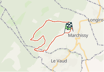
Tour Wandern von 8,2 km verfügbar auf Waadt, District de Nyon, Marchissy. Diese Tour wird von Miclm vorgeschlagen.
Beschreibung
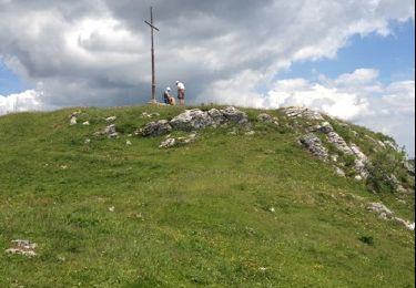
Petite rando (7 km) facile et familiale.
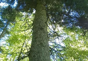
Passage sur route puis chemin dans une belle forêt.
Vue sur le Lac Léman et les Alpes dont le Mont Blanc.
Départ / Retour Village de Marchissy
Route des montagnes
au nord du village prendre chemin de Magnin
Ort
Land:
Switzerland
Region :
Waadt
Abteilung/Provinz :
District de Nyon
Kommune :
Marchissy
Standort:
Unknown
Gehen Sie:(Dec)
Gehen Sie:(UTM)
288076 ; 5152059 (32T) N.
Kommentare
Touren in der Umgebung
![Tour Zu Fuß Marchissy - Sentier du Coq - Photo](https://media.geolcdn.com/t/375/260/8a5237db-6f33-409f-bb3a-20fc00640a5b.jpeg&format=jpg&maxdim=2)
![Zu Fuß Zu Fuß](https://static1.geolcdn.com/sitytour/trail-icons/100.png)
Sentier du Coq
Zu Fuß
Einfach
Marchissy,
Waadt,
District de Nyon,
Switzerland
![](/images/other/stat-length.png)
5,7 km | 11,2 km-effort
2h 32min
![](https://static1.geolcdn.com/siteimages/upload/files/16400158638029165_repeat_loop_refresh_sync_direction_icon.png)
Nein
![Tour Wandern Bassins - Creux du Croue depuis route des Pralets - Photo](https://media.geolcdn.com/t/375/260/ext.jpg?maxdim=2&url=https%3A%2F%2Fservices.sitytrail.com%2FGeolivesWS%2FDownloadMedia.ashx%3FTrailID%3D843799%26Media%3D20171010161753.jpg)
![Wandern Wandern](https://static1.geolcdn.com/sitytour/trail-icons/101.png)
Creux du Croue depuis route des Pralets
Wandern
Einfach
Bassins,
Waadt,
District de Nyon,
Switzerland
![](/images/other/stat-length.png)
14,5 km | 21 km-effort
4h 16min
![](https://static1.geolcdn.com/siteimages/upload/files/16400158638029165_repeat_loop_refresh_sync_direction_icon.png)
Ja
![Tour Wandern Bassins - Le Sentier des Begnines - Photo](https://media.geolcdn.com/t/375/260/ext.jpg?maxdim=2&url=https%3A%2F%2Fservices.sitytrail.com%2FGeolivesWS%2FDownloadMedia.ashx%3FTrailID%3D471164%26Media%3D20150912143228.jpg)
![Wandern Wandern](https://static1.geolcdn.com/sitytour/trail-icons/101.png)
Le Sentier des Begnines
Wandern
Einfach
Bassins,
Waadt,
District de Nyon,
Switzerland
![](/images/other/stat-length.png)
14,9 km | 21 km-effort
4h 0min
![](https://static1.geolcdn.com/siteimages/upload/files/16400158638029165_repeat_loop_refresh_sync_direction_icon.png)
Ja
![Tour Wandern Bassins - Mont Sala depuis près des Pralets - Photo](https://media.geolcdn.com/t/375/260/ext.jpg?maxdim=2&url=https%3A%2F%2Fservices.sitytrail.com%2FGeolivesWS%2FDownloadMedia.ashx%3FTrailID%3D202144%26Media%3D20130702130051.jpg)
![Wandern Wandern](https://static1.geolcdn.com/sitytour/trail-icons/101.png)
Mont Sala depuis près des Pralets
Wandern
Einfach
Bassins,
Waadt,
District de Nyon,
Switzerland
![](/images/other/stat-length.png)
7,4 km | 10,7 km-effort
2h 17min
![](https://static1.geolcdn.com/siteimages/upload/files/16400158638029165_repeat_loop_refresh_sync_direction_icon.png)
Ja
![Tour Andere Aktivitäten Bassins - y10_tobleroneweg - Photo](https://media.geolcdn.com/t/375/260/ext.jpg?maxdim=2&url=https%3A%2F%2Fstatic1.geolcdn.com%2Fsiteimages%2Fupload%2Ffiles%2F1545311037marcheuse_200dpi.jpg)
![Andere Aktivitäten Andere Aktivitäten](https://static1.geolcdn.com/sitytour/trail-icons/900.png)
y10_tobleroneweg
Andere Aktivitäten
Sehr leicht
Bassins,
Waadt,
District de Nyon,
Switzerland
![](/images/other/stat-length.png)
23 km | 28 km-effort
5h 54min
![](https://static1.geolcdn.com/siteimages/upload/files/16400158638029165_repeat_loop_refresh_sync_direction_icon.png)
Nein
![Tour Wandern Bassins - Vom Jura zum Genfersee entlang der](https://media.geolcdn.com/t/375/260/ext.jpg?maxdim=2&url=https%3A%2F%2Fstatic1.geolcdn.com%2Fsiteimages%2Fupload%2Ffiles%2F1553511878bg_sport_marche.png)
![Wandern Wandern](https://static1.geolcdn.com/sitytour/trail-icons/101.png)
Vom Jura zum Genfersee entlang der "Toblerone-Zacken"
Wandern
Sehr leicht
Bassins,
Waadt,
District de Nyon,
Switzerland
![](/images/other/stat-length.png)
18,8 km | 22 km-effort
Unbekannt
![](https://static1.geolcdn.com/siteimages/upload/files/16400158638029165_repeat_loop_refresh_sync_direction_icon.png)
Nein
![Tour Wandern Burtigny - sentier des pierres (région de Rolle) 04.16 - Photo](https://media.geolcdn.com/t/375/260/ext.jpg?maxdim=2&url=https%3A%2F%2Fservices.sitytrail.com%2FGeolivesWS%2FDownloadMedia.ashx%3FTrailID%3D564684%26Media%3D7f385a9c-134d-4f50-a897-cb5746d1e20c.jpg)
![Wandern Wandern](https://static1.geolcdn.com/sitytour/trail-icons/101.png)
sentier des pierres (région de Rolle) 04.16
Wandern
Medium
Burtigny,
Waadt,
District de Nyon,
Switzerland
![](/images/other/stat-length.png)
15,8 km | 23 km-effort
5h 2min
![](https://static1.geolcdn.com/siteimages/upload/files/16400158638029165_repeat_loop_refresh_sync_direction_icon.png)
Ja
![Tour Wandern Bassins - La Pesette - Le Planet - Les Chenevieres - Photo](https://media.geolcdn.com/t/375/260/ext.jpg?maxdim=2&url=https%3A%2F%2Fstatic1.geolcdn.com%2Fsiteimages%2Fupload%2Ffiles%2F1553511878bg_sport_marche.png)
![Wandern Wandern](https://static1.geolcdn.com/sitytour/trail-icons/101.png)
La Pesette - Le Planet - Les Chenevieres
Wandern
Einfach
Bassins,
Waadt,
District de Nyon,
Switzerland
![](/images/other/stat-length.png)
8,8 km | 12,5 km-effort
2h 7min
![](https://static1.geolcdn.com/siteimages/upload/files/16400158638029165_repeat_loop_refresh_sync_direction_icon.png)
Ja
![Tour Mountainbike Bassins - Les Pralets - Place d'Armes - Rionde Dessus - Le Vaud - Photo](https://media.geolcdn.com/t/375/260/ext.jpg?maxdim=2&url=https%3A%2F%2Fstatic1.geolcdn.com%2Fsiteimages%2Fupload%2Ffiles%2F1524743154velo.jpg)
![Mountainbike Mountainbike](https://static1.geolcdn.com/sitytour/trail-icons/202.png)
Les Pralets - Place d'Armes - Rionde Dessus - Le Vaud
Mountainbike
Medium
Bassins,
Waadt,
District de Nyon,
Switzerland
![](/images/other/stat-length.png)
23 km | 30 km-effort
2h 19min
![](https://static1.geolcdn.com/siteimages/upload/files/16400158638029165_repeat_loop_refresh_sync_direction_icon.png)
Nein