![](/images/other/stat-length.png)
![Tour Zu Fuß Mennecy - Boucle autour de Mennecy - Photo](https://media.geolcdn.com/t/1900/400/8b9e4ef7-6f9c-44d6-bf15-96d045d2bf54.jpg&format=pjpeg&maxdim=2)
Boucle autour de Mennecy
chessyca
Benutzer GUIDE
![Länge](/images/other/stat-length.png)
Länge
27 km
![Maximale Höhe](https://static1.geolcdn.com/siteimages/upload/files/1508320355ic_sort_altitude_max_24dp.png)
Maximale Höhe
92 m
![Positive Höhendifferenz](https://static1.geolcdn.com/siteimages/upload/files/1508320355ic_sort_den_pos_24dp.png)
Positive Höhendifferenz
235 m
![Km-Effort](/images/other/stat-length.png)
Km-Effort
30 km
![Min. Höhe](https://static1.geolcdn.com/siteimages/upload/files/1508320355ic_sort_altitude_min_24dp.png)
Min. Höhe
46 m
![Negative Höhendifferenz](https://static1.geolcdn.com/siteimages/upload/files/1508320355ic_sort_den_neg_24dp.png)
Negative Höhendifferenz
231 m
![Boucle](https://static1.geolcdn.com/siteimages/upload/files/16400158638029165_repeat_loop_refresh_sync_direction_icon.png)
Boucle
Ja
Erstellungsdatum :
2022-03-09 08:12:05.916
Letzte Änderung :
2022-03-09 17:38:43.19
![Zu Fuß](https://static1.geolcdn.com/sitytour/trail-icons/100.png)
6h48
Schwierigkeit : Medium
![Scannen Sie diesen QR-Code, um die Tour in der SityTrail-Anwendung zu öffnen](https://capi.geolives.com/qq0zvz2zws4bq2lad0pu/sitytour/trails/3160800/qr.png?size=200)
Kostenlosegpshiking-Anwendung
Über SityTrail
Tour Zu Fuß von 27 km verfügbar auf Île-de-France, Essonne, Mennecy. Diese Tour wird von chessyca vorgeschlagen.
Beschreibung
Rando menée par Jean Marc.
Au fil de l'eau avec les étangs et marais d'Echarcon, L'aqueduc de la Vanne, etc...
Très agréable en cette saison ( pas de moustiques)
Ort
Land:
France
Region :
Île-de-France
Abteilung/Provinz :
Essonne
Kommune :
Mennecy
Standort:
Unknown
Gehen Sie:(Dec)
Gehen Sie:(UTM)
457526 ; 5379401 (31U) N.
Kommentare
Touren in der Umgebung
![Tour Wandern Écharcon - Autour de Vert le Petit - Photo](https://media.geolcdn.com/t/375/260/ext.jpg?maxdim=2&url=https%3A%2F%2Fservices.sitytrail.com%2FGeolivesWS%2FDownloadMedia.ashx%3FTrailID%3D102739%26Media%3D3871_4.jpg)
![Wandern Wandern](https://static1.geolcdn.com/sitytour/trail-icons/101.png)
Autour de Vert le Petit
Wandern
Medium
(1)
Écharcon,
Île-de-France,
Essonne,
France
![](/images/other/stat-length.png)
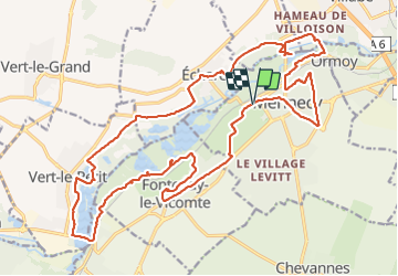
16 km | 17,9 km-effort
4h 0min
![](https://static1.geolcdn.com/siteimages/upload/files/16400158638029165_repeat_loop_refresh_sync_direction_icon.png)
Ja
![Tour Zu Fuß Mennecy - Boucle 20 km autour de Mennecy - Photo](https://media.geolcdn.com/t/375/260/a0d84bba-b7da-4081-b724-5ae5c2d178d5.jpg&format=jpg&maxdim=2)
![Zu Fuß Zu Fuß](https://static1.geolcdn.com/sitytour/trail-icons/100.png)
Boucle 20 km autour de Mennecy
Zu Fuß
Medium
Mennecy,
Île-de-France,
Essonne,
France
![](/images/other/stat-length.png)
20 km | 23 km-effort
5h 15min
![](https://static1.geolcdn.com/siteimages/upload/files/16400158638029165_repeat_loop_refresh_sync_direction_icon.png)
Ja
![Tour Wandern Ballancourt-sur-Essonne - Rando Ballancourt 15 km BM - Photo](https://media.geolcdn.com/t/375/260/8977c33c-1145-4a4f-97a7-a064e00deb0b.jpg&format=jpg&maxdim=2)
![Wandern Wandern](https://static1.geolcdn.com/sitytour/trail-icons/101.png)
Rando Ballancourt 15 km BM
Wandern
Schwierig
(1)
Ballancourt-sur-Essonne,
Île-de-France,
Essonne,
France
![](/images/other/stat-length.png)
14,8 km | 16,9 km-effort
3h 50min
![](https://static1.geolcdn.com/siteimages/upload/files/16400158638029165_repeat_loop_refresh_sync_direction_icon.png)
Ja
![Tour Wandern Mennecy - Boucle 23 km au départ de Mennecy - Photo](https://media.geolcdn.com/t/375/260/d9409c0b-4ad5-436d-94de-44694c25ec6a.jpg&format=jpg&maxdim=2)
![Wandern Wandern](https://static1.geolcdn.com/sitytour/trail-icons/101.png)
Boucle 23 km au départ de Mennecy
Wandern
Sehr leicht
Mennecy,
Île-de-France,
Essonne,
France
![](/images/other/stat-length.png)
23 km | 26 km-effort
4h 52min
![](https://static1.geolcdn.com/siteimages/upload/files/16400158638029165_repeat_loop_refresh_sync_direction_icon.png)
Ja
![Tour Wandern Ballancourt-sur-Essonne - Boucle autour de Ballancourt - Photo](https://media.geolcdn.com/t/375/260/726c3226-57e6-4792-b7bd-15745463bf1c.jpg&format=jpg&maxdim=2)
![Wandern Wandern](https://static1.geolcdn.com/sitytour/trail-icons/101.png)
Boucle autour de Ballancourt
Wandern
Medium
Ballancourt-sur-Essonne,
Île-de-France,
Essonne,
France
![](/images/other/stat-length.png)
21 km | 25 km-effort
4h 47min
![](https://static1.geolcdn.com/siteimages/upload/files/16400158638029165_repeat_loop_refresh_sync_direction_icon.png)
Ja
![Tour Zu Fuß Mennecy - Les Etangs de Mennecy - Photo](https://media.geolcdn.com/t/375/260/ext.jpg?maxdim=2&url=https%3A%2F%2Fstatic1.geolcdn.com%2Fsiteimages%2Fupload%2Ffiles%2F1545311037marcheuse_200dpi.jpg)
![Zu Fuß Zu Fuß](https://static1.geolcdn.com/sitytour/trail-icons/100.png)
Les Etangs de Mennecy
Zu Fuß
Schwierig
(1)
Mennecy,
Île-de-France,
Essonne,
France
![](/images/other/stat-length.png)
18,5 km | 21 km-effort
4h 3min
![](https://static1.geolcdn.com/siteimages/upload/files/16400158638029165_repeat_loop_refresh_sync_direction_icon.png)
Ja
![Tour Zu Fuß Mennecy - Boucle autour des étangs à partir de Mennecy - Photo](https://media.geolcdn.com/t/375/260/acd79014-5cb8-4e86-a933-bcce20350a9e.jpg&format=jpg&maxdim=2)
![Zu Fuß Zu Fuß](https://static1.geolcdn.com/sitytour/trail-icons/100.png)
Boucle autour des étangs à partir de Mennecy
Zu Fuß
Sehr leicht
Mennecy,
Île-de-France,
Essonne,
France
![](/images/other/stat-length.png)
18,6 km | 21 km-effort
4h 44min
![](https://static1.geolcdn.com/siteimages/upload/files/16400158638029165_repeat_loop_refresh_sync_direction_icon.png)
Ja
![Tour Wandern Saintry-sur-Seine - Boucle 30 km Saintry - Seine Port - Morsang - Photo](https://media.geolcdn.com/t/375/260/147882bb-b6f1-4169-80d4-53a2e8169cea.jpg&format=jpg&maxdim=2)
![Wandern Wandern](https://static1.geolcdn.com/sitytour/trail-icons/101.png)
Boucle 30 km Saintry - Seine Port - Morsang
Wandern
Sehr leicht
Saintry-sur-Seine,
Île-de-France,
Essonne,
France
![](/images/other/stat-length.png)
29 km | 34 km-effort
6h 15min
![](https://static1.geolcdn.com/siteimages/upload/files/16400158638029165_repeat_loop_refresh_sync_direction_icon.png)
Ja
![Tour Mountainbike Bondoufle - rando](https://media.geolcdn.com/t/375/260/ext.jpg?maxdim=2&url=https%3A%2F%2Fstatic1.geolcdn.com%2Fsiteimages%2Fupload%2Ffiles%2F1524743154velo.jpg)
![Mountainbike Mountainbike](https://static1.geolcdn.com/sitytour/trail-icons/202.png)
rando "sec" dimanche 07/02/2021
Mountainbike
Einfach
(1)
Bondoufle,
Île-de-France,
Essonne,
France
![](/images/other/stat-length.png)
56 km | 63 km-effort
8min
![](https://static1.geolcdn.com/siteimages/upload/files/16400158638029165_repeat_loop_refresh_sync_direction_icon.png)
Ja