


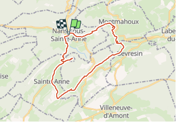

15 km | 19,2 km-effort


Benutzer


Kostenlosegpshiking-Anwendung
 SityTrail
IGN / Geografische Institute
SityTrail World
Die Welt öffnet sich für Sie
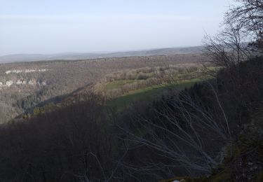
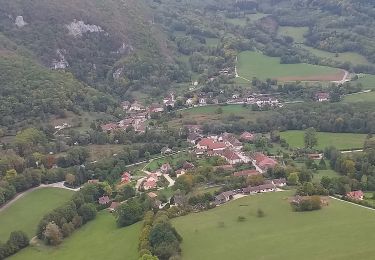
Tour Wandern von 16,1 km verfügbar auf Burgund und Freigrafschaft, Doubs, Nans-sous-Sainte-Anne. Diese Tour wird von eltonnermou vorgeschlagen.
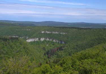
Cette très belle randonnée pédestre vous entrainera à travers différents paysages, jalonnée de nombreux beaux points de vues sur le village de Nans sous st Anne, sa vallée ; puis une fois sur le plateau les monts du Haut-Doubs et de la Suisse. La montée est très engageante (800m env), avec certains passages difficiles, les bâtons sont conseillés. Le pont du diable va vous surprendre par sa hauteur et la vue qu'il offre. A sa sortie prendre à gauche (comme la trace vous y invite) mais à l'entrée du champ prendre encore à gauche pour rejoindre un chemin (ne pas suivre la trace) et arriver à Crouzet-Migette par un chemin plus tranquille que la route.
La montée sur Montmahoux est rude mais la récompense vous attend au sommet, profitez en : plein les yeux.
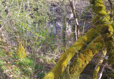
Avec un peu de chance, vous rencontrerez de belles surprises : chamois sur les pentes escarpées du secteur, renard, écureuil. Vous pourrez apprécier la diversité de la flore.
Possibilité de faire ce parcours dans l'autre sens (la montée est toute aussi difficile).
 "
data-pinterest-text="Pin it"
data-tweet-text="share on twitter"
data-facebook-share-url="https://www.sitytrail.com/de/trails/3160547-nansxsousxsaintexanne--nans-sous-st-anne-xpont-du-diablex/?photo=1#lg=1&slide=1"
data-twitter-share-url="https://www.sitytrail.com/de/trails/3160547-nansxsousxsaintexanne--nans-sous-st-anne-xpont-du-diablex/?photo=1#lg=1&slide=1"
data-googleplus-share-url="https://www.sitytrail.com/de/trails/3160547-nansxsousxsaintexanne--nans-sous-st-anne-xpont-du-diablex/?photo=1#lg=1&slide=1"
data-pinterest-share-url="https://www.sitytrail.com/de/trails/3160547-nansxsousxsaintexanne--nans-sous-st-anne-xpont-du-diablex/?photo=1#lg=1&slide=1">
"
data-pinterest-text="Pin it"
data-tweet-text="share on twitter"
data-facebook-share-url="https://www.sitytrail.com/de/trails/3160547-nansxsousxsaintexanne--nans-sous-st-anne-xpont-du-diablex/?photo=1#lg=1&slide=1"
data-twitter-share-url="https://www.sitytrail.com/de/trails/3160547-nansxsousxsaintexanne--nans-sous-st-anne-xpont-du-diablex/?photo=1#lg=1&slide=1"
data-googleplus-share-url="https://www.sitytrail.com/de/trails/3160547-nansxsousxsaintexanne--nans-sous-st-anne-xpont-du-diablex/?photo=1#lg=1&slide=1"
data-pinterest-share-url="https://www.sitytrail.com/de/trails/3160547-nansxsousxsaintexanne--nans-sous-st-anne-xpont-du-diablex/?photo=1#lg=1&slide=1">
 "
data-pinterest-text="Pin it"
data-tweet-text="share on twitter"
data-facebook-share-url="https://www.sitytrail.com/de/trails/3160547-nansxsousxsaintexanne--nans-sous-st-anne-xpont-du-diablex/?photo=2#lg=1&slide=2"
data-twitter-share-url="https://www.sitytrail.com/de/trails/3160547-nansxsousxsaintexanne--nans-sous-st-anne-xpont-du-diablex/?photo=2#lg=1&slide=2"
data-googleplus-share-url="https://www.sitytrail.com/de/trails/3160547-nansxsousxsaintexanne--nans-sous-st-anne-xpont-du-diablex/?photo=2#lg=1&slide=2"
data-pinterest-share-url="https://www.sitytrail.com/de/trails/3160547-nansxsousxsaintexanne--nans-sous-st-anne-xpont-du-diablex/?photo=2#lg=1&slide=2">
"
data-pinterest-text="Pin it"
data-tweet-text="share on twitter"
data-facebook-share-url="https://www.sitytrail.com/de/trails/3160547-nansxsousxsaintexanne--nans-sous-st-anne-xpont-du-diablex/?photo=2#lg=1&slide=2"
data-twitter-share-url="https://www.sitytrail.com/de/trails/3160547-nansxsousxsaintexanne--nans-sous-st-anne-xpont-du-diablex/?photo=2#lg=1&slide=2"
data-googleplus-share-url="https://www.sitytrail.com/de/trails/3160547-nansxsousxsaintexanne--nans-sous-st-anne-xpont-du-diablex/?photo=2#lg=1&slide=2"
data-pinterest-share-url="https://www.sitytrail.com/de/trails/3160547-nansxsousxsaintexanne--nans-sous-st-anne-xpont-du-diablex/?photo=2#lg=1&slide=2">
 "
data-pinterest-text="Pin it"
data-tweet-text="share on twitter"
data-facebook-share-url="https://www.sitytrail.com/de/trails/3160547-nansxsousxsaintexanne--nans-sous-st-anne-xpont-du-diablex/?photo=3#lg=1&slide=3"
data-twitter-share-url="https://www.sitytrail.com/de/trails/3160547-nansxsousxsaintexanne--nans-sous-st-anne-xpont-du-diablex/?photo=3#lg=1&slide=3"
data-googleplus-share-url="https://www.sitytrail.com/de/trails/3160547-nansxsousxsaintexanne--nans-sous-st-anne-xpont-du-diablex/?photo=3#lg=1&slide=3"
data-pinterest-share-url="https://www.sitytrail.com/de/trails/3160547-nansxsousxsaintexanne--nans-sous-st-anne-xpont-du-diablex/?photo=3#lg=1&slide=3">
"
data-pinterest-text="Pin it"
data-tweet-text="share on twitter"
data-facebook-share-url="https://www.sitytrail.com/de/trails/3160547-nansxsousxsaintexanne--nans-sous-st-anne-xpont-du-diablex/?photo=3#lg=1&slide=3"
data-twitter-share-url="https://www.sitytrail.com/de/trails/3160547-nansxsousxsaintexanne--nans-sous-st-anne-xpont-du-diablex/?photo=3#lg=1&slide=3"
data-googleplus-share-url="https://www.sitytrail.com/de/trails/3160547-nansxsousxsaintexanne--nans-sous-st-anne-xpont-du-diablex/?photo=3#lg=1&slide=3"
data-pinterest-share-url="https://www.sitytrail.com/de/trails/3160547-nansxsousxsaintexanne--nans-sous-st-anne-xpont-du-diablex/?photo=3#lg=1&slide=3">
 "
data-pinterest-text="Pin it"
data-tweet-text="share on twitter"
data-facebook-share-url="https://www.sitytrail.com/de/trails/3160547-nansxsousxsaintexanne--nans-sous-st-anne-xpont-du-diablex/?photo=4#lg=1&slide=4"
data-twitter-share-url="https://www.sitytrail.com/de/trails/3160547-nansxsousxsaintexanne--nans-sous-st-anne-xpont-du-diablex/?photo=4#lg=1&slide=4"
data-googleplus-share-url="https://www.sitytrail.com/de/trails/3160547-nansxsousxsaintexanne--nans-sous-st-anne-xpont-du-diablex/?photo=4#lg=1&slide=4"
data-pinterest-share-url="https://www.sitytrail.com/de/trails/3160547-nansxsousxsaintexanne--nans-sous-st-anne-xpont-du-diablex/?photo=4#lg=1&slide=4">
"
data-pinterest-text="Pin it"
data-tweet-text="share on twitter"
data-facebook-share-url="https://www.sitytrail.com/de/trails/3160547-nansxsousxsaintexanne--nans-sous-st-anne-xpont-du-diablex/?photo=4#lg=1&slide=4"
data-twitter-share-url="https://www.sitytrail.com/de/trails/3160547-nansxsousxsaintexanne--nans-sous-st-anne-xpont-du-diablex/?photo=4#lg=1&slide=4"
data-googleplus-share-url="https://www.sitytrail.com/de/trails/3160547-nansxsousxsaintexanne--nans-sous-st-anne-xpont-du-diablex/?photo=4#lg=1&slide=4"
data-pinterest-share-url="https://www.sitytrail.com/de/trails/3160547-nansxsousxsaintexanne--nans-sous-st-anne-xpont-du-diablex/?photo=4#lg=1&slide=4">
 "
data-pinterest-text="Pin it"
data-tweet-text="share on twitter"
data-facebook-share-url="https://www.sitytrail.com/de/trails/3160547-nansxsousxsaintexanne--nans-sous-st-anne-xpont-du-diablex/?photo=5#lg=1&slide=5"
data-twitter-share-url="https://www.sitytrail.com/de/trails/3160547-nansxsousxsaintexanne--nans-sous-st-anne-xpont-du-diablex/?photo=5#lg=1&slide=5"
data-googleplus-share-url="https://www.sitytrail.com/de/trails/3160547-nansxsousxsaintexanne--nans-sous-st-anne-xpont-du-diablex/?photo=5#lg=1&slide=5"
data-pinterest-share-url="https://www.sitytrail.com/de/trails/3160547-nansxsousxsaintexanne--nans-sous-st-anne-xpont-du-diablex/?photo=5#lg=1&slide=5">
"
data-pinterest-text="Pin it"
data-tweet-text="share on twitter"
data-facebook-share-url="https://www.sitytrail.com/de/trails/3160547-nansxsousxsaintexanne--nans-sous-st-anne-xpont-du-diablex/?photo=5#lg=1&slide=5"
data-twitter-share-url="https://www.sitytrail.com/de/trails/3160547-nansxsousxsaintexanne--nans-sous-st-anne-xpont-du-diablex/?photo=5#lg=1&slide=5"
data-googleplus-share-url="https://www.sitytrail.com/de/trails/3160547-nansxsousxsaintexanne--nans-sous-st-anne-xpont-du-diablex/?photo=5#lg=1&slide=5"
data-pinterest-share-url="https://www.sitytrail.com/de/trails/3160547-nansxsousxsaintexanne--nans-sous-st-anne-xpont-du-diablex/?photo=5#lg=1&slide=5">
 "
data-pinterest-text="Pin it"
data-tweet-text="share on twitter"
data-facebook-share-url="https://www.sitytrail.com/de/trails/3160547-nansxsousxsaintexanne--nans-sous-st-anne-xpont-du-diablex/?photo=6#lg=1&slide=6"
data-twitter-share-url="https://www.sitytrail.com/de/trails/3160547-nansxsousxsaintexanne--nans-sous-st-anne-xpont-du-diablex/?photo=6#lg=1&slide=6"
data-googleplus-share-url="https://www.sitytrail.com/de/trails/3160547-nansxsousxsaintexanne--nans-sous-st-anne-xpont-du-diablex/?photo=6#lg=1&slide=6"
data-pinterest-share-url="https://www.sitytrail.com/de/trails/3160547-nansxsousxsaintexanne--nans-sous-st-anne-xpont-du-diablex/?photo=6#lg=1&slide=6">
"
data-pinterest-text="Pin it"
data-tweet-text="share on twitter"
data-facebook-share-url="https://www.sitytrail.com/de/trails/3160547-nansxsousxsaintexanne--nans-sous-st-anne-xpont-du-diablex/?photo=6#lg=1&slide=6"
data-twitter-share-url="https://www.sitytrail.com/de/trails/3160547-nansxsousxsaintexanne--nans-sous-st-anne-xpont-du-diablex/?photo=6#lg=1&slide=6"
data-googleplus-share-url="https://www.sitytrail.com/de/trails/3160547-nansxsousxsaintexanne--nans-sous-st-anne-xpont-du-diablex/?photo=6#lg=1&slide=6"
data-pinterest-share-url="https://www.sitytrail.com/de/trails/3160547-nansxsousxsaintexanne--nans-sous-st-anne-xpont-du-diablex/?photo=6#lg=1&slide=6">
 "
data-pinterest-text="Pin it"
data-tweet-text="share on twitter"
data-facebook-share-url="https://www.sitytrail.com/de/trails/3160547-nansxsousxsaintexanne--nans-sous-st-anne-xpont-du-diablex/?photo=7#lg=1&slide=7"
data-twitter-share-url="https://www.sitytrail.com/de/trails/3160547-nansxsousxsaintexanne--nans-sous-st-anne-xpont-du-diablex/?photo=7#lg=1&slide=7"
data-googleplus-share-url="https://www.sitytrail.com/de/trails/3160547-nansxsousxsaintexanne--nans-sous-st-anne-xpont-du-diablex/?photo=7#lg=1&slide=7"
data-pinterest-share-url="https://www.sitytrail.com/de/trails/3160547-nansxsousxsaintexanne--nans-sous-st-anne-xpont-du-diablex/?photo=7#lg=1&slide=7">
"
data-pinterest-text="Pin it"
data-tweet-text="share on twitter"
data-facebook-share-url="https://www.sitytrail.com/de/trails/3160547-nansxsousxsaintexanne--nans-sous-st-anne-xpont-du-diablex/?photo=7#lg=1&slide=7"
data-twitter-share-url="https://www.sitytrail.com/de/trails/3160547-nansxsousxsaintexanne--nans-sous-st-anne-xpont-du-diablex/?photo=7#lg=1&slide=7"
data-googleplus-share-url="https://www.sitytrail.com/de/trails/3160547-nansxsousxsaintexanne--nans-sous-st-anne-xpont-du-diablex/?photo=7#lg=1&slide=7"
data-pinterest-share-url="https://www.sitytrail.com/de/trails/3160547-nansxsousxsaintexanne--nans-sous-st-anne-xpont-du-diablex/?photo=7#lg=1&slide=7">
 "
data-pinterest-text="Pin it"
data-tweet-text="share on twitter"
data-facebook-share-url="https://www.sitytrail.com/de/trails/3160547-nansxsousxsaintexanne--nans-sous-st-anne-xpont-du-diablex/?photo=8#lg=1&slide=8"
data-twitter-share-url="https://www.sitytrail.com/de/trails/3160547-nansxsousxsaintexanne--nans-sous-st-anne-xpont-du-diablex/?photo=8#lg=1&slide=8"
data-googleplus-share-url="https://www.sitytrail.com/de/trails/3160547-nansxsousxsaintexanne--nans-sous-st-anne-xpont-du-diablex/?photo=8#lg=1&slide=8"
data-pinterest-share-url="https://www.sitytrail.com/de/trails/3160547-nansxsousxsaintexanne--nans-sous-st-anne-xpont-du-diablex/?photo=8#lg=1&slide=8">
"
data-pinterest-text="Pin it"
data-tweet-text="share on twitter"
data-facebook-share-url="https://www.sitytrail.com/de/trails/3160547-nansxsousxsaintexanne--nans-sous-st-anne-xpont-du-diablex/?photo=8#lg=1&slide=8"
data-twitter-share-url="https://www.sitytrail.com/de/trails/3160547-nansxsousxsaintexanne--nans-sous-st-anne-xpont-du-diablex/?photo=8#lg=1&slide=8"
data-googleplus-share-url="https://www.sitytrail.com/de/trails/3160547-nansxsousxsaintexanne--nans-sous-st-anne-xpont-du-diablex/?photo=8#lg=1&slide=8"
data-pinterest-share-url="https://www.sitytrail.com/de/trails/3160547-nansxsousxsaintexanne--nans-sous-st-anne-xpont-du-diablex/?photo=8#lg=1&slide=8">
 "
data-pinterest-text="Pin it"
data-tweet-text="share on twitter"
data-facebook-share-url="https://www.sitytrail.com/de/trails/3160547-nansxsousxsaintexanne--nans-sous-st-anne-xpont-du-diablex/?photo=9#lg=1&slide=9"
data-twitter-share-url="https://www.sitytrail.com/de/trails/3160547-nansxsousxsaintexanne--nans-sous-st-anne-xpont-du-diablex/?photo=9#lg=1&slide=9"
data-googleplus-share-url="https://www.sitytrail.com/de/trails/3160547-nansxsousxsaintexanne--nans-sous-st-anne-xpont-du-diablex/?photo=9#lg=1&slide=9"
data-pinterest-share-url="https://www.sitytrail.com/de/trails/3160547-nansxsousxsaintexanne--nans-sous-st-anne-xpont-du-diablex/?photo=9#lg=1&slide=9">
"
data-pinterest-text="Pin it"
data-tweet-text="share on twitter"
data-facebook-share-url="https://www.sitytrail.com/de/trails/3160547-nansxsousxsaintexanne--nans-sous-st-anne-xpont-du-diablex/?photo=9#lg=1&slide=9"
data-twitter-share-url="https://www.sitytrail.com/de/trails/3160547-nansxsousxsaintexanne--nans-sous-st-anne-xpont-du-diablex/?photo=9#lg=1&slide=9"
data-googleplus-share-url="https://www.sitytrail.com/de/trails/3160547-nansxsousxsaintexanne--nans-sous-st-anne-xpont-du-diablex/?photo=9#lg=1&slide=9"
data-pinterest-share-url="https://www.sitytrail.com/de/trails/3160547-nansxsousxsaintexanne--nans-sous-st-anne-xpont-du-diablex/?photo=9#lg=1&slide=9">
 "
data-pinterest-text="Pin it"
data-tweet-text="share on twitter"
data-facebook-share-url="https://www.sitytrail.com/de/trails/3160547-nansxsousxsaintexanne--nans-sous-st-anne-xpont-du-diablex/?photo=10#lg=1&slide=10"
data-twitter-share-url="https://www.sitytrail.com/de/trails/3160547-nansxsousxsaintexanne--nans-sous-st-anne-xpont-du-diablex/?photo=10#lg=1&slide=10"
data-googleplus-share-url="https://www.sitytrail.com/de/trails/3160547-nansxsousxsaintexanne--nans-sous-st-anne-xpont-du-diablex/?photo=10#lg=1&slide=10"
data-pinterest-share-url="https://www.sitytrail.com/de/trails/3160547-nansxsousxsaintexanne--nans-sous-st-anne-xpont-du-diablex/?photo=10#lg=1&slide=10">
"
data-pinterest-text="Pin it"
data-tweet-text="share on twitter"
data-facebook-share-url="https://www.sitytrail.com/de/trails/3160547-nansxsousxsaintexanne--nans-sous-st-anne-xpont-du-diablex/?photo=10#lg=1&slide=10"
data-twitter-share-url="https://www.sitytrail.com/de/trails/3160547-nansxsousxsaintexanne--nans-sous-st-anne-xpont-du-diablex/?photo=10#lg=1&slide=10"
data-googleplus-share-url="https://www.sitytrail.com/de/trails/3160547-nansxsousxsaintexanne--nans-sous-st-anne-xpont-du-diablex/?photo=10#lg=1&slide=10"
data-pinterest-share-url="https://www.sitytrail.com/de/trails/3160547-nansxsousxsaintexanne--nans-sous-st-anne-xpont-du-diablex/?photo=10#lg=1&slide=10">
 "
data-pinterest-text="Pin it"
data-tweet-text="share on twitter"
data-facebook-share-url="https://www.sitytrail.com/de/trails/3160547-nansxsousxsaintexanne--nans-sous-st-anne-xpont-du-diablex/?photo=11#lg=1&slide=11"
data-twitter-share-url="https://www.sitytrail.com/de/trails/3160547-nansxsousxsaintexanne--nans-sous-st-anne-xpont-du-diablex/?photo=11#lg=1&slide=11"
data-googleplus-share-url="https://www.sitytrail.com/de/trails/3160547-nansxsousxsaintexanne--nans-sous-st-anne-xpont-du-diablex/?photo=11#lg=1&slide=11"
data-pinterest-share-url="https://www.sitytrail.com/de/trails/3160547-nansxsousxsaintexanne--nans-sous-st-anne-xpont-du-diablex/?photo=11#lg=1&slide=11">
"
data-pinterest-text="Pin it"
data-tweet-text="share on twitter"
data-facebook-share-url="https://www.sitytrail.com/de/trails/3160547-nansxsousxsaintexanne--nans-sous-st-anne-xpont-du-diablex/?photo=11#lg=1&slide=11"
data-twitter-share-url="https://www.sitytrail.com/de/trails/3160547-nansxsousxsaintexanne--nans-sous-st-anne-xpont-du-diablex/?photo=11#lg=1&slide=11"
data-googleplus-share-url="https://www.sitytrail.com/de/trails/3160547-nansxsousxsaintexanne--nans-sous-st-anne-xpont-du-diablex/?photo=11#lg=1&slide=11"
data-pinterest-share-url="https://www.sitytrail.com/de/trails/3160547-nansxsousxsaintexanne--nans-sous-st-anne-xpont-du-diablex/?photo=11#lg=1&slide=11">
 "
data-pinterest-text="Pin it"
data-tweet-text="share on twitter"
data-facebook-share-url="https://www.sitytrail.com/de/trails/3160547-nansxsousxsaintexanne--nans-sous-st-anne-xpont-du-diablex/?photo=12#lg=1&slide=12"
data-twitter-share-url="https://www.sitytrail.com/de/trails/3160547-nansxsousxsaintexanne--nans-sous-st-anne-xpont-du-diablex/?photo=12#lg=1&slide=12"
data-googleplus-share-url="https://www.sitytrail.com/de/trails/3160547-nansxsousxsaintexanne--nans-sous-st-anne-xpont-du-diablex/?photo=12#lg=1&slide=12"
data-pinterest-share-url="https://www.sitytrail.com/de/trails/3160547-nansxsousxsaintexanne--nans-sous-st-anne-xpont-du-diablex/?photo=12#lg=1&slide=12">
"
data-pinterest-text="Pin it"
data-tweet-text="share on twitter"
data-facebook-share-url="https://www.sitytrail.com/de/trails/3160547-nansxsousxsaintexanne--nans-sous-st-anne-xpont-du-diablex/?photo=12#lg=1&slide=12"
data-twitter-share-url="https://www.sitytrail.com/de/trails/3160547-nansxsousxsaintexanne--nans-sous-st-anne-xpont-du-diablex/?photo=12#lg=1&slide=12"
data-googleplus-share-url="https://www.sitytrail.com/de/trails/3160547-nansxsousxsaintexanne--nans-sous-st-anne-xpont-du-diablex/?photo=12#lg=1&slide=12"
data-pinterest-share-url="https://www.sitytrail.com/de/trails/3160547-nansxsousxsaintexanne--nans-sous-st-anne-xpont-du-diablex/?photo=12#lg=1&slide=12">
 "
data-pinterest-text="Pin it"
data-tweet-text="share on twitter"
data-facebook-share-url="https://www.sitytrail.com/de/trails/3160547-nansxsousxsaintexanne--nans-sous-st-anne-xpont-du-diablex/?photo=13#lg=1&slide=13"
data-twitter-share-url="https://www.sitytrail.com/de/trails/3160547-nansxsousxsaintexanne--nans-sous-st-anne-xpont-du-diablex/?photo=13#lg=1&slide=13"
data-googleplus-share-url="https://www.sitytrail.com/de/trails/3160547-nansxsousxsaintexanne--nans-sous-st-anne-xpont-du-diablex/?photo=13#lg=1&slide=13"
data-pinterest-share-url="https://www.sitytrail.com/de/trails/3160547-nansxsousxsaintexanne--nans-sous-st-anne-xpont-du-diablex/?photo=13#lg=1&slide=13">
"
data-pinterest-text="Pin it"
data-tweet-text="share on twitter"
data-facebook-share-url="https://www.sitytrail.com/de/trails/3160547-nansxsousxsaintexanne--nans-sous-st-anne-xpont-du-diablex/?photo=13#lg=1&slide=13"
data-twitter-share-url="https://www.sitytrail.com/de/trails/3160547-nansxsousxsaintexanne--nans-sous-st-anne-xpont-du-diablex/?photo=13#lg=1&slide=13"
data-googleplus-share-url="https://www.sitytrail.com/de/trails/3160547-nansxsousxsaintexanne--nans-sous-st-anne-xpont-du-diablex/?photo=13#lg=1&slide=13"
data-pinterest-share-url="https://www.sitytrail.com/de/trails/3160547-nansxsousxsaintexanne--nans-sous-st-anne-xpont-du-diablex/?photo=13#lg=1&slide=13">
 "
data-pinterest-text="Pin it"
data-tweet-text="share on twitter"
data-facebook-share-url="https://www.sitytrail.com/de/trails/3160547-nansxsousxsaintexanne--nans-sous-st-anne-xpont-du-diablex/?photo=14#lg=1&slide=14"
data-twitter-share-url="https://www.sitytrail.com/de/trails/3160547-nansxsousxsaintexanne--nans-sous-st-anne-xpont-du-diablex/?photo=14#lg=1&slide=14"
data-googleplus-share-url="https://www.sitytrail.com/de/trails/3160547-nansxsousxsaintexanne--nans-sous-st-anne-xpont-du-diablex/?photo=14#lg=1&slide=14"
data-pinterest-share-url="https://www.sitytrail.com/de/trails/3160547-nansxsousxsaintexanne--nans-sous-st-anne-xpont-du-diablex/?photo=14#lg=1&slide=14">
"
data-pinterest-text="Pin it"
data-tweet-text="share on twitter"
data-facebook-share-url="https://www.sitytrail.com/de/trails/3160547-nansxsousxsaintexanne--nans-sous-st-anne-xpont-du-diablex/?photo=14#lg=1&slide=14"
data-twitter-share-url="https://www.sitytrail.com/de/trails/3160547-nansxsousxsaintexanne--nans-sous-st-anne-xpont-du-diablex/?photo=14#lg=1&slide=14"
data-googleplus-share-url="https://www.sitytrail.com/de/trails/3160547-nansxsousxsaintexanne--nans-sous-st-anne-xpont-du-diablex/?photo=14#lg=1&slide=14"
data-pinterest-share-url="https://www.sitytrail.com/de/trails/3160547-nansxsousxsaintexanne--nans-sous-st-anne-xpont-du-diablex/?photo=14#lg=1&slide=14">
 "
data-pinterest-text="Pin it"
data-tweet-text="share on twitter"
data-facebook-share-url="https://www.sitytrail.com/de/trails/3160547-nansxsousxsaintexanne--nans-sous-st-anne-xpont-du-diablex/?photo=15#lg=1&slide=15"
data-twitter-share-url="https://www.sitytrail.com/de/trails/3160547-nansxsousxsaintexanne--nans-sous-st-anne-xpont-du-diablex/?photo=15#lg=1&slide=15"
data-googleplus-share-url="https://www.sitytrail.com/de/trails/3160547-nansxsousxsaintexanne--nans-sous-st-anne-xpont-du-diablex/?photo=15#lg=1&slide=15"
data-pinterest-share-url="https://www.sitytrail.com/de/trails/3160547-nansxsousxsaintexanne--nans-sous-st-anne-xpont-du-diablex/?photo=15#lg=1&slide=15">
"
data-pinterest-text="Pin it"
data-tweet-text="share on twitter"
data-facebook-share-url="https://www.sitytrail.com/de/trails/3160547-nansxsousxsaintexanne--nans-sous-st-anne-xpont-du-diablex/?photo=15#lg=1&slide=15"
data-twitter-share-url="https://www.sitytrail.com/de/trails/3160547-nansxsousxsaintexanne--nans-sous-st-anne-xpont-du-diablex/?photo=15#lg=1&slide=15"
data-googleplus-share-url="https://www.sitytrail.com/de/trails/3160547-nansxsousxsaintexanne--nans-sous-st-anne-xpont-du-diablex/?photo=15#lg=1&slide=15"
data-pinterest-share-url="https://www.sitytrail.com/de/trails/3160547-nansxsousxsaintexanne--nans-sous-st-anne-xpont-du-diablex/?photo=15#lg=1&slide=15">
 "
data-pinterest-text="Pin it"
data-tweet-text="share on twitter"
data-facebook-share-url="https://www.sitytrail.com/de/trails/3160547-nansxsousxsaintexanne--nans-sous-st-anne-xpont-du-diablex/?photo=16#lg=1&slide=16"
data-twitter-share-url="https://www.sitytrail.com/de/trails/3160547-nansxsousxsaintexanne--nans-sous-st-anne-xpont-du-diablex/?photo=16#lg=1&slide=16"
data-googleplus-share-url="https://www.sitytrail.com/de/trails/3160547-nansxsousxsaintexanne--nans-sous-st-anne-xpont-du-diablex/?photo=16#lg=1&slide=16"
data-pinterest-share-url="https://www.sitytrail.com/de/trails/3160547-nansxsousxsaintexanne--nans-sous-st-anne-xpont-du-diablex/?photo=16#lg=1&slide=16">
"
data-pinterest-text="Pin it"
data-tweet-text="share on twitter"
data-facebook-share-url="https://www.sitytrail.com/de/trails/3160547-nansxsousxsaintexanne--nans-sous-st-anne-xpont-du-diablex/?photo=16#lg=1&slide=16"
data-twitter-share-url="https://www.sitytrail.com/de/trails/3160547-nansxsousxsaintexanne--nans-sous-st-anne-xpont-du-diablex/?photo=16#lg=1&slide=16"
data-googleplus-share-url="https://www.sitytrail.com/de/trails/3160547-nansxsousxsaintexanne--nans-sous-st-anne-xpont-du-diablex/?photo=16#lg=1&slide=16"
data-pinterest-share-url="https://www.sitytrail.com/de/trails/3160547-nansxsousxsaintexanne--nans-sous-st-anne-xpont-du-diablex/?photo=16#lg=1&slide=16">
 "
data-pinterest-text="Pin it"
data-tweet-text="share on twitter"
data-facebook-share-url="https://www.sitytrail.com/de/trails/3160547-nansxsousxsaintexanne--nans-sous-st-anne-xpont-du-diablex/?photo=17#lg=1&slide=17"
data-twitter-share-url="https://www.sitytrail.com/de/trails/3160547-nansxsousxsaintexanne--nans-sous-st-anne-xpont-du-diablex/?photo=17#lg=1&slide=17"
data-googleplus-share-url="https://www.sitytrail.com/de/trails/3160547-nansxsousxsaintexanne--nans-sous-st-anne-xpont-du-diablex/?photo=17#lg=1&slide=17"
data-pinterest-share-url="https://www.sitytrail.com/de/trails/3160547-nansxsousxsaintexanne--nans-sous-st-anne-xpont-du-diablex/?photo=17#lg=1&slide=17">
"
data-pinterest-text="Pin it"
data-tweet-text="share on twitter"
data-facebook-share-url="https://www.sitytrail.com/de/trails/3160547-nansxsousxsaintexanne--nans-sous-st-anne-xpont-du-diablex/?photo=17#lg=1&slide=17"
data-twitter-share-url="https://www.sitytrail.com/de/trails/3160547-nansxsousxsaintexanne--nans-sous-st-anne-xpont-du-diablex/?photo=17#lg=1&slide=17"
data-googleplus-share-url="https://www.sitytrail.com/de/trails/3160547-nansxsousxsaintexanne--nans-sous-st-anne-xpont-du-diablex/?photo=17#lg=1&slide=17"
data-pinterest-share-url="https://www.sitytrail.com/de/trails/3160547-nansxsousxsaintexanne--nans-sous-st-anne-xpont-du-diablex/?photo=17#lg=1&slide=17">
 "
data-pinterest-text="Pin it"
data-tweet-text="share on twitter"
data-facebook-share-url="https://www.sitytrail.com/de/trails/3160547-nansxsousxsaintexanne--nans-sous-st-anne-xpont-du-diablex/?photo=18#lg=1&slide=18"
data-twitter-share-url="https://www.sitytrail.com/de/trails/3160547-nansxsousxsaintexanne--nans-sous-st-anne-xpont-du-diablex/?photo=18#lg=1&slide=18"
data-googleplus-share-url="https://www.sitytrail.com/de/trails/3160547-nansxsousxsaintexanne--nans-sous-st-anne-xpont-du-diablex/?photo=18#lg=1&slide=18"
data-pinterest-share-url="https://www.sitytrail.com/de/trails/3160547-nansxsousxsaintexanne--nans-sous-st-anne-xpont-du-diablex/?photo=18#lg=1&slide=18">
"
data-pinterest-text="Pin it"
data-tweet-text="share on twitter"
data-facebook-share-url="https://www.sitytrail.com/de/trails/3160547-nansxsousxsaintexanne--nans-sous-st-anne-xpont-du-diablex/?photo=18#lg=1&slide=18"
data-twitter-share-url="https://www.sitytrail.com/de/trails/3160547-nansxsousxsaintexanne--nans-sous-st-anne-xpont-du-diablex/?photo=18#lg=1&slide=18"
data-googleplus-share-url="https://www.sitytrail.com/de/trails/3160547-nansxsousxsaintexanne--nans-sous-st-anne-xpont-du-diablex/?photo=18#lg=1&slide=18"
data-pinterest-share-url="https://www.sitytrail.com/de/trails/3160547-nansxsousxsaintexanne--nans-sous-st-anne-xpont-du-diablex/?photo=18#lg=1&slide=18">
 "
data-pinterest-text="Pin it"
data-tweet-text="share on twitter"
data-facebook-share-url="https://www.sitytrail.com/de/trails/3160547-nansxsousxsaintexanne--nans-sous-st-anne-xpont-du-diablex/?photo=19#lg=1&slide=19"
data-twitter-share-url="https://www.sitytrail.com/de/trails/3160547-nansxsousxsaintexanne--nans-sous-st-anne-xpont-du-diablex/?photo=19#lg=1&slide=19"
data-googleplus-share-url="https://www.sitytrail.com/de/trails/3160547-nansxsousxsaintexanne--nans-sous-st-anne-xpont-du-diablex/?photo=19#lg=1&slide=19"
data-pinterest-share-url="https://www.sitytrail.com/de/trails/3160547-nansxsousxsaintexanne--nans-sous-st-anne-xpont-du-diablex/?photo=19#lg=1&slide=19">
"
data-pinterest-text="Pin it"
data-tweet-text="share on twitter"
data-facebook-share-url="https://www.sitytrail.com/de/trails/3160547-nansxsousxsaintexanne--nans-sous-st-anne-xpont-du-diablex/?photo=19#lg=1&slide=19"
data-twitter-share-url="https://www.sitytrail.com/de/trails/3160547-nansxsousxsaintexanne--nans-sous-st-anne-xpont-du-diablex/?photo=19#lg=1&slide=19"
data-googleplus-share-url="https://www.sitytrail.com/de/trails/3160547-nansxsousxsaintexanne--nans-sous-st-anne-xpont-du-diablex/?photo=19#lg=1&slide=19"
data-pinterest-share-url="https://www.sitytrail.com/de/trails/3160547-nansxsousxsaintexanne--nans-sous-st-anne-xpont-du-diablex/?photo=19#lg=1&slide=19">

Wandern

Wandern

Wandern

Wandern
Wandern
Wandern
Wandern
Wandern

Wandern