Tour Wandern Aywaille - Route from Balade de la Mine d'or - Photo

Route from Balade de la Mine d'or

 Geert H.
Geert H.

Benutzer

© OpenStreetMap contributors
Länge
Länge
8,7 km
Maximale Höhe
Maximale Höhe
477 m
Positive Höhendifferenz
310 m
Km-Effort
Km-Effort  
12,8 km
Min. Höhe
Min. Höhe
184 m
Negative Höhendifferenz
306 m
Boucle
Boucle
Ja
Erstellungsdatum :
2022-03-06 17:29:40.503
Letzte Änderung :
2022-03-07 08:19:06.075

(0 Nachricht)

Wandern
Wandern
2h54
Schwierigkeit : Schwierig

Scannen Sie diesen QR-Code, um die Tour in der SityTrail-Anwendung zu öffnen

Kostenlosegpshiking-Anwendung

Logo SityTrail SityTrail

IGN / Geografische Institute

SityTrail aus dem App Store herunterladen SityTrail von Google Play herunterladen

Logo SityTrail SityTrail World

Die Welt öffnet sich für Sie

SityTrail aus dem App Store herunterladen SityTrail von Google Play herunterladen SityTrail auf Huawei AppGallery herunterladen

Über SityTrail

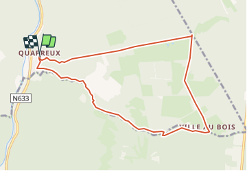
Tour Wandern von 8,7 km verfügbar auf Wallonien, Lüttich, Aywaille. Diese Tour wird von Geert H. vorgeschlagen.

Beschreibung

Circular walk following the river Chefna upstream and coming back through forests
Circular walk from Quarreux (part of Aywaille). You're following the river Chefna for the first part and coming back through the forests.
The Chefna is as nice as the very popular Ninglinspo river nearby that is running parallel to the Chefna but with fewer visitors.
Your mostly following the "Ballade de la Mine d'or" where you can see some remnants of a gold mining operation during the 1800's.
Te trail is gently going up and down, just at the end there is a steep part downhill on the Mâle Heid.

Höhenprofil

Ort

Land:
Belgium
Region :
Wallonien
Abteilung/Provinz :
Lüttich
Kommune :
Aywaille
Standort:
Unknown
Gehen Sie:(UTM)
694594 ; 5591954 (31U) N.

Touren in der Umgebung

Tour Wandern Theux - RB-Lg-24_La-Reid_via-racc-1 - Photo
Wandern
PRO

Wandern

(11)
Theux, Wallonien, Lüttich, Belgium
15,9 km | 21 km-effort
4h 50min
Ja
Tour Wandern Theux - RB-Lg-24_La-Reid - Photo
Wandern
PRO

Wandern

(8)
Theux, Wallonien, Lüttich, Belgium
21 km | 28 km-effort
6h 22min
Ja
Tour Wandern Stoumont - Lorcé, Natura 2000 - Des sites qui valent le détour, Lg13 - Photo
Wandern
GUIDE+

Wandern

Einfach
(7)
Stoumont, Wallonien, Lüttich, Belgium
6,1 km | 8,9 km-effort
1h 57min
Ja
Tour Wandern Aywaille - RB-Lg-12 - De Sougné-Remouchamps à Deigné et retour - Photo
Wandern
PRO

Wandern

Schwierig
(9)
Aywaille, Wallonien, Lüttich, Belgium
24 km | 34 km-effort
7h 39min
Ja
Tour Wandern Aywaille - aywaille  . florzé . martinrive . septroux . aywaille - Photo
Wandern
GUIDE
stef789

Wandern

Einfach
(6)
Aywaille, Wallonien, Lüttich, Belgium
11,1 km | 15,4 km-effort
2h 48min
Ja
Tour Wandern Aywaille - Petite remontée du Ninglispo - Photo
Wandern
henriantoine

Wandern

Medium
(9)
Aywaille, Wallonien, Lüttich, Belgium
6,7 km | 9,7 km-effort
2h 11min
Ja
Tour Wandern Aywaille - RB-LG-12 - Raccourci 2 - Photo
Wandern
PRO

Wandern

Schwierig
(6)
Aywaille, Wallonien, Lüttich, Belgium
17 km | 25 km-effort
5h 46min
Ja
Tour Wandern Stoumont - RB-LG-13 - Par monts et par vaux autour de Stoumont - Photo
Wandern
PRO

Wandern

Sehr schwierig
(11)
Stoumont, Wallonien, Lüttich, Belgium
23 km | 32 km-effort
7h 19min
Ja
Tour Wandern Stoumont - 2022-02-03_17h52m52_StoumontP14PromenadedessommetsdelaLienne - Photo
Wandern
GUIDE
mumu.larandonneuse

Wandern

Medium
(2)
Stoumont, Wallonien, Lüttich, Belgium
16,1 km | 23 km-effort
5h 11min
Ja


Schließen
Meine Abonnements