![](/images/other/stat-length.png)
![Tour Zu Fuß Thanstein - Thanstein-Warberg-Weg](https://media.geolcdn.com/t/1900/400/ext.pjpeg?maxdim=2&url=https%3A%2F%2Fstatic1.geolcdn.com%2Fsiteimages%2Fupload%2Ffiles%2F1545311037marcheuse_200dpi.jpg)
Thanstein-Warberg-Weg "T 11"
SityTrail - itinéraires balisés pédestres
Tous les sentiers balisés d’Europe PRO
![Länge](/images/other/stat-length.png)
Länge
14,1 km
![Maximale Höhe](https://static1.geolcdn.com/siteimages/upload/files/1508320355ic_sort_altitude_max_24dp.png)
Maximale Höhe
630 m
![Positive Höhendifferenz](https://static1.geolcdn.com/siteimages/upload/files/1508320355ic_sort_den_pos_24dp.png)
Positive Höhendifferenz
354 m
![Km-Effort](/images/other/stat-length.png)
Km-Effort
18,8 km
![Min. Höhe](https://static1.geolcdn.com/siteimages/upload/files/1508320355ic_sort_altitude_min_24dp.png)
Min. Höhe
502 m
![Negative Höhendifferenz](https://static1.geolcdn.com/siteimages/upload/files/1508320355ic_sort_den_neg_24dp.png)
Negative Höhendifferenz
359 m
![Boucle](https://static1.geolcdn.com/siteimages/upload/files/16400158638029165_repeat_loop_refresh_sync_direction_icon.png)
Boucle
Nein
Kennzeichnung
Erstellungsdatum :
2022-02-21 08:18:28.156
Letzte Änderung :
2022-02-21 08:18:28.156
![Zu Fuß](https://static1.geolcdn.com/sitytour/trail-icons/100.png)
4h16
Schwierigkeit : Einfach
![Scannen Sie diesen QR-Code, um die Tour in der SityTrail-Anwendung zu öffnen](https://capi.geolives.com/qq0zvz2zws4bq2lad0pu/sitytour/trails/3136664/qr.png?size=200)
Kostenlosegpshiking-Anwendung
Über SityTrail
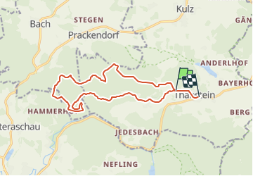
Tour Zu Fuß von 14,1 km verfügbar auf Bayern, Landkreis Schwandorf, Thanstein. Diese Tour wird von SityTrail - itinéraires balisés pédestres vorgeschlagen.
Beschreibung
Trail created by Verwaltungsgem. Neunburg v. Wald.
Symbol: weißes Rechteck mit schwarzer Schrift T 11 oder gelbes Rechteck m. schwarzer Schrift T 11
Ort
Land:
Germany
Region :
Bayern
Abteilung/Provinz :
Landkreis Schwandorf
Kommune :
Thanstein
Standort:
Unknown
Gehen Sie:(Dec)
Gehen Sie:(UTM)
315576 ; 5472935 (33U) N.
Kommentare
Touren in der Umgebung
![Tour Zu Fuß Thanstein - Moosweg - Photo](https://media.geolcdn.com/t/375/260/ext.jpg?maxdim=2&url=https%3A%2F%2Fmedia.geolcdn.com%2Ff%2F1b793e07-7979-45a2-b2ee-2247369056e3.jpeg)
![Zu Fuß Zu Fuß](https://static1.geolcdn.com/sitytour/trail-icons/100.png)
Moosweg
Zu Fuß
Einfach
Thanstein,
Bayern,
Landkreis Schwandorf,
Germany
![](/images/other/stat-length.png)
7,9 km | 10,1 km-effort
2h 18min
![](https://static1.geolcdn.com/siteimages/upload/files/16400158638029165_repeat_loop_refresh_sync_direction_icon.png)
Nein
![Tour Zu Fuß Thanstein - Kaisereichenweg - Photo](https://media.geolcdn.com/t/375/260/ext.jpg?maxdim=2&url=https%3A%2F%2Fmedia.geolcdn.com%2Ff%2Fcda28eb4-819a-4750-a893-aa0bfcb85ab1.jpeg)
![Zu Fuß Zu Fuß](https://static1.geolcdn.com/sitytour/trail-icons/100.png)
Kaisereichenweg
Zu Fuß
Einfach
Thanstein,
Bayern,
Landkreis Schwandorf,
Germany
![](/images/other/stat-length.png)
5,4 km | 7,3 km-effort
1h 39min
![](https://static1.geolcdn.com/siteimages/upload/files/16400158638029165_repeat_loop_refresh_sync_direction_icon.png)
Nein
![Tour Zu Fuß Thanstein - Mühlweiherweg](https://media.geolcdn.com/t/375/260/ext.jpg?maxdim=2&url=https%3A%2F%2Fmedia.geolcdn.com%2Ff%2F1b793e07-7979-45a2-b2ee-2247369056e3.jpeg)
![Zu Fuß Zu Fuß](https://static1.geolcdn.com/sitytour/trail-icons/100.png)
Mühlweiherweg "T 8"
Zu Fuß
Einfach
Thanstein,
Bayern,
Landkreis Schwandorf,
Germany
![](/images/other/stat-length.png)
9 km | 11,6 km-effort
2h 37min
![](https://static1.geolcdn.com/siteimages/upload/files/16400158638029165_repeat_loop_refresh_sync_direction_icon.png)
Ja
![Tour Zu Fuß Neunburg vorm Wald - Schwarzwihrbergweg - Photo](https://media.geolcdn.com/t/375/260/ext.jpg?maxdim=2&url=https%3A%2F%2Fmedia.geolcdn.com%2Ff%2Feb056ad9-ae63-4485-bc2a-42f9b604a256.jpeg)
![Zu Fuß Zu Fuß](https://static1.geolcdn.com/sitytour/trail-icons/100.png)
Schwarzwihrbergweg
Zu Fuß
Medium
Neunburg vorm Wald,
Bayern,
Landkreis Schwandorf,
Germany
![](/images/other/stat-length.png)
19,9 km | 26 km-effort
6h 0min
![](https://static1.geolcdn.com/siteimages/upload/files/16400158638029165_repeat_loop_refresh_sync_direction_icon.png)
Nein
![Tour Zu Fuß Rötz - Bauhof-Thanstein-Weg](https://media.geolcdn.com/t/375/260/ext.jpg?maxdim=2&url=https%3A%2F%2Fmedia.geolcdn.com%2Ff%2F1b793e07-7979-45a2-b2ee-2247369056e3.jpeg)
![Zu Fuß Zu Fuß](https://static1.geolcdn.com/sitytour/trail-icons/100.png)
Bauhof-Thanstein-Weg "T 4"
Zu Fuß
Einfach
Rötz,
Bayern,
Landkreis Cham,
Germany
![](/images/other/stat-length.png)
5,7 km | 7,1 km-effort
1h 36min
![](https://static1.geolcdn.com/siteimages/upload/files/16400158638029165_repeat_loop_refresh_sync_direction_icon.png)
Nein
![Tour Zu Fuß Thanstein - Eibensteinweg T 5 - Photo](https://media.geolcdn.com/t/375/260/ext.jpg?maxdim=2&url=https%3A%2F%2Fmedia.geolcdn.com%2Ff%2F1b793e07-7979-45a2-b2ee-2247369056e3.jpeg)
![Zu Fuß Zu Fuß](https://static1.geolcdn.com/sitytour/trail-icons/100.png)
Eibensteinweg T 5
Zu Fuß
Einfach
Thanstein,
Bayern,
Landkreis Schwandorf,
Germany
![](/images/other/stat-length.png)
9,9 km | 13,2 km-effort
3h 0min
![](https://static1.geolcdn.com/siteimages/upload/files/16400158638029165_repeat_loop_refresh_sync_direction_icon.png)
Ja
![Tour Zu Fuß Thanstein - Engelbildweg T 7 - Photo](https://media.geolcdn.com/t/375/260/ext.jpg?maxdim=2&url=https%3A%2F%2Fmedia.geolcdn.com%2Ff%2F1b793e07-7979-45a2-b2ee-2247369056e3.jpeg)
![Zu Fuß Zu Fuß](https://static1.geolcdn.com/sitytour/trail-icons/100.png)
Engelbildweg T 7
Zu Fuß
Einfach
Thanstein,
Bayern,
Landkreis Schwandorf,
Germany
![](/images/other/stat-length.png)
5 km | 6,7 km-effort
1h 31min
![](https://static1.geolcdn.com/siteimages/upload/files/16400158638029165_repeat_loop_refresh_sync_direction_icon.png)
Ja
![Tour Zu Fuß Thanstein - Bründelsteinweg](https://media.geolcdn.com/t/375/260/ext.jpg?maxdim=2&url=https%3A%2F%2Fmedia.geolcdn.com%2Ff%2F1b793e07-7979-45a2-b2ee-2247369056e3.jpeg)
![Zu Fuß Zu Fuß](https://static1.geolcdn.com/sitytour/trail-icons/100.png)
Bründelsteinweg "T2"
Zu Fuß
Einfach
Thanstein,
Bayern,
Landkreis Schwandorf,
Germany
![](/images/other/stat-length.png)
3,2 km | 4,1 km-effort
55min
![](https://static1.geolcdn.com/siteimages/upload/files/16400158638029165_repeat_loop_refresh_sync_direction_icon.png)
Ja
![Tour Zu Fuß Thanstein - Thanstein-Bauhof-Weg](https://media.geolcdn.com/t/375/260/ext.jpg?maxdim=2&url=https%3A%2F%2Fmedia.geolcdn.com%2Ff%2F1b793e07-7979-45a2-b2ee-2247369056e3.jpeg)
![Zu Fuß Zu Fuß](https://static1.geolcdn.com/sitytour/trail-icons/100.png)
Thanstein-Bauhof-Weg "T3"
Zu Fuß
Einfach
Thanstein,
Bayern,
Landkreis Schwandorf,
Germany
![](/images/other/stat-length.png)
6,6 km | 9,8 km-effort
2h 12min
![](https://static1.geolcdn.com/siteimages/upload/files/16400158638029165_repeat_loop_refresh_sync_direction_icon.png)
Nein