![](/images/other/stat-length.png)
![Tour Zu Fuß Soneja - Soneja - La Dehesa - Photo](https://media.geolcdn.com/t/1900/400/ext.pjpeg?maxdim=2&url=https%3A%2F%2Fmedia.geolcdn.com%2Ff%2F402439b0-185e-4f97-b441-489e2040f0dd.jpeg)
Soneja - La Dehesa
SityTrail - itinéraires balisés pédestres
Tous les sentiers balisés d’Europe PRO
![Länge](/images/other/stat-length.png)
Länge
14,6 km
![Maximale Höhe](https://static1.geolcdn.com/siteimages/upload/files/1508320355ic_sort_altitude_max_24dp.png)
Maximale Höhe
445 m
![Positive Höhendifferenz](https://static1.geolcdn.com/siteimages/upload/files/1508320355ic_sort_den_pos_24dp.png)
Positive Höhendifferenz
435 m
![Km-Effort](/images/other/stat-length.png)
Km-Effort
20 km
![Min. Höhe](https://static1.geolcdn.com/siteimages/upload/files/1508320355ic_sort_altitude_min_24dp.png)
Min. Höhe
221 m
![Negative Höhendifferenz](https://static1.geolcdn.com/siteimages/upload/files/1508320355ic_sort_den_neg_24dp.png)
Negative Höhendifferenz
391 m
![Boucle](https://static1.geolcdn.com/siteimages/upload/files/16400158638029165_repeat_loop_refresh_sync_direction_icon.png)
Boucle
Nein
Kennzeichnung
Erstellungsdatum :
2022-02-17 11:04:13.398
Letzte Änderung :
2022-02-17 11:04:13.398
![Zu Fuß](https://static1.geolcdn.com/sitytour/trail-icons/100.png)
4h36
Schwierigkeit : Medium
![Scannen Sie diesen QR-Code, um die Tour in der SityTrail-Anwendung zu öffnen](https://capi.geolives.com/qq0zvz2zws4bq2lad0pu/sitytour/trails/3131157/qr.png?size=200)
Kostenlosegpshiking-Anwendung
Über SityTrail
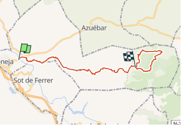
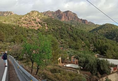
Tour Zu Fuß von 14,6 km verfügbar auf Valencianische Gemeinschaft, Castelló / Castellón, Soneja. Diese Tour wird von SityTrail - itinéraires balisés pédestres vorgeschlagen.
Beschreibung
Symbol: white strip on top of yellow strip
Ort
Land:
Spain
Region :
Valencianische Gemeinschaft
Abteilung/Provinz :
Castelló / Castellón
Kommune :
Soneja
Standort:
Unknown
Gehen Sie:(Dec)
Gehen Sie:(UTM)
720785 ; 4410551 (30S) N.
Kommentare
Touren in der Umgebung
![Tour Zu Fuß Torralba del Pinar - Trans- Espadan - Photo](https://media.geolcdn.com/t/375/260/ext.jpg?maxdim=2&url=https%3A%2F%2Fmedia.geolcdn.com%2Ff%2Feb49fabb-944e-4d71-beba-0d1a65c85d6b.jpeg)
![Zu Fuß Zu Fuß](https://static1.geolcdn.com/sitytour/trail-icons/100.png)
Trans- Espadan
Zu Fuß
Einfach
Torralba del Pinar,
Valencianische Gemeinschaft,
Castelló / Castellón,
Spain
![](/images/other/stat-length.png)
12,8 km | 18,2 km-effort
4h 8min
![](https://static1.geolcdn.com/siteimages/upload/files/16400158638029165_repeat_loop_refresh_sync_direction_icon.png)
Nein
![Tour Wandern Sagunt / Sagunto - gilet - Photo](https://media.geolcdn.com/t/375/260/ext.jpg?maxdim=2&url=https%3A%2F%2Fservices.sitytrail.com%2FGeolivesWS%2FDownloadMedia.ashx%3FTrailID%3D509477%26Media%3Dfix__20160104163903.jpg)
![Wandern Wandern](https://static1.geolcdn.com/sitytour/trail-icons/101.png)
gilet
Wandern
Einfach
Sagunt / Sagunto,
Valencianische Gemeinschaft,
Valencia,
Spain
![](/images/other/stat-length.png)
6,9 km | 8,4 km-effort
1h 32min
![](https://static1.geolcdn.com/siteimages/upload/files/16400158638029165_repeat_loop_refresh_sync_direction_icon.png)
Ja
![Tour Wandern Segart - Pico Garbi - Photo](https://media.geolcdn.com/t/375/260/ext.jpg?maxdim=2&url=https%3A%2F%2Fmedia.geolcdn.com%2Ff%2Fc4758e5f-582d-4bd3-9634-1ab3268ff726.jpg)
![Wandern Wandern](https://static1.geolcdn.com/sitytour/trail-icons/101.png)
Pico Garbi
Wandern
Schwierig
Segart,
Valencianische Gemeinschaft,
Valencia,
Spain
![](/images/other/stat-length.png)
7,6 km | 13,2 km-effort
2h 21min
![](https://static1.geolcdn.com/siteimages/upload/files/16400158638029165_repeat_loop_refresh_sync_direction_icon.png)
Ja
![Tour Wandern Olocau - autour de olocau - Photo](https://media.geolcdn.com/t/375/260/ext.jpg?maxdim=2&url=https%3A%2F%2Fstatic1.geolcdn.com%2Fsiteimages%2Fupload%2Ffiles%2F1553511878bg_sport_marche.png)
![Wandern Wandern](https://static1.geolcdn.com/sitytour/trail-icons/101.png)
autour de olocau
Wandern
Sehr schwierig
Olocau,
Valencianische Gemeinschaft,
Valencia,
Spain
![](/images/other/stat-length.png)
14,2 km | 19,6 km-effort
3h 34min
![](https://static1.geolcdn.com/siteimages/upload/files/16400158638029165_repeat_loop_refresh_sync_direction_icon.png)
Nein
![Tour Zu Fuß Chóvar - Ruta patrionio - Photo](https://media.geolcdn.com/t/375/260/ext.jpg?maxdim=2&url=https%3A%2F%2Fstatic1.geolcdn.com%2Fsiteimages%2Fupload%2Ffiles%2F1545311037marcheuse_200dpi.jpg)
![Zu Fuß Zu Fuß](https://static1.geolcdn.com/sitytour/trail-icons/100.png)
Ruta patrionio
Zu Fuß
Einfach
Chóvar,
Valencianische Gemeinschaft,
Castelló / Castellón,
Spain
![](/images/other/stat-length.png)
4,7 km | 8 km-effort
1h 49min
![](https://static1.geolcdn.com/siteimages/upload/files/16400158638029165_repeat_loop_refresh_sync_direction_icon.png)
Ja
![Tour Wandern Alcudia de Veo - Alcudía de Veo / Pico Espadan / Finestra / Penya del Pastor / Alcudia - Photo](https://media.geolcdn.com/t/375/260/ext.jpg?maxdim=2&url=https%3A%2F%2Fstatic1.geolcdn.com%2Fsiteimages%2Fupload%2Ffiles%2F1553511878bg_sport_marche.png)
![Wandern Wandern](https://static1.geolcdn.com/sitytour/trail-icons/101.png)
Alcudía de Veo / Pico Espadan / Finestra / Penya del Pastor / Alcudia
Wandern
Medium
Alcudia de Veo,
Valencianische Gemeinschaft,
Castelló / Castellón,
Spain
![](/images/other/stat-length.png)
11,5 km | 22 km-effort
6h 59min
![](https://static1.geolcdn.com/siteimages/upload/files/16400158638029165_repeat_loop_refresh_sync_direction_icon.png)
Ja
![Tour Wandern Albalat dels Tarongers - gr-10-circular-la-canal-del-garbi-un-pequeno-reto-penyes-del - Photo](https://media.geolcdn.com/t/375/260/ext.jpg?maxdim=2&url=https%3A%2F%2Fstatic1.geolcdn.com%2Fsiteimages%2Fupload%2Ffiles%2F1553511878bg_sport_marche.png)
![Wandern Wandern](https://static1.geolcdn.com/sitytour/trail-icons/101.png)
gr-10-circular-la-canal-del-garbi-un-pequeno-reto-penyes-del
Wandern
Sehr schwierig
Albalat dels Tarongers,
Valencianische Gemeinschaft,
Valencia,
Spain
![](/images/other/stat-length.png)
8,2 km | 14,2 km-effort
3h 1min
![](https://static1.geolcdn.com/siteimages/upload/files/16400158638029165_repeat_loop_refresh_sync_direction_icon.png)
Ja
![Tour Wandern la Vall d'Uixó - la wall du d'uixo 2024 - Photo](https://media.geolcdn.com/t/375/260/ext.jpg?maxdim=2&url=https%3A%2F%2Fstatic1.geolcdn.com%2Fsiteimages%2Fupload%2Ffiles%2F1553511878bg_sport_marche.png)
![Wandern Wandern](https://static1.geolcdn.com/sitytour/trail-icons/101.png)
la wall du d'uixo 2024
Wandern
Schwierig
la Vall d'Uixó,
Valencianische Gemeinschaft,
Castelló / Castellón,
Spain
![](/images/other/stat-length.png)
9,9 km | 17,7 km-effort
4h 11min
![](https://static1.geolcdn.com/siteimages/upload/files/16400158638029165_repeat_loop_refresh_sync_direction_icon.png)
Ja
![Tour Wandern Eslida - Eslida col de Barres puntal de l'Aljup Eslida - Photo](https://media.geolcdn.com/t/375/260/ext.jpg?maxdim=2&url=https%3A%2F%2Fstatic1.geolcdn.com%2Fsiteimages%2Fupload%2Ffiles%2F1553511878bg_sport_marche.png)
![Wandern Wandern](https://static1.geolcdn.com/sitytour/trail-icons/101.png)
Eslida col de Barres puntal de l'Aljup Eslida
Wandern
Medium
Eslida,
Valencianische Gemeinschaft,
Castelló / Castellón,
Spain
![](/images/other/stat-length.png)
14,4 km | 23 km-effort
6h 47min
![](https://static1.geolcdn.com/siteimages/upload/files/16400158638029165_repeat_loop_refresh_sync_direction_icon.png)
Ja