![](/images/other/stat-length.png)
![Tour Nordic Walking Ludres - Ludres (Plateau de) 11 800m +155m - Photo](https://media.geolcdn.com/t/1900/400/ext.pjpeg?maxdim=2&url=https%3A%2F%2Fstatic1.geolcdn.com%2Fsiteimages%2Fupload%2Ffiles%2F1545311037marcheuse_200dpi.jpg)
Ludres (Plateau de) 11 800m +155m
DanielROLLET
Benutzer
![Länge](/images/other/stat-length.png)
Länge
11,8 km
![Maximale Höhe](https://static1.geolcdn.com/siteimages/upload/files/1508320355ic_sort_altitude_max_24dp.png)
Maximale Höhe
422 m
![Positive Höhendifferenz](https://static1.geolcdn.com/siteimages/upload/files/1508320355ic_sort_den_pos_24dp.png)
Positive Höhendifferenz
155 m
![Km-Effort](/images/other/stat-length.png)
Km-Effort
13,9 km
![Min. Höhe](https://static1.geolcdn.com/siteimages/upload/files/1508320355ic_sort_altitude_min_24dp.png)
Min. Höhe
369 m
![Negative Höhendifferenz](https://static1.geolcdn.com/siteimages/upload/files/1508320355ic_sort_den_neg_24dp.png)
Negative Höhendifferenz
153 m
![Boucle](https://static1.geolcdn.com/siteimages/upload/files/16400158638029165_repeat_loop_refresh_sync_direction_icon.png)
Boucle
Ja
Erstellungsdatum :
2022-02-17 07:48:55.906
Letzte Änderung :
2022-02-17 15:24:46.089
![Nordic Walking](https://static1.geolcdn.com/sitytour/trail-icons/102.png)
2h25
Schwierigkeit : Einfach
![Scannen Sie diesen QR-Code, um die Tour in der SityTrail-Anwendung zu öffnen](https://capi.geolives.com/qq0zvz2zws4bq2lad0pu/sitytour/trails/3130426/qr.png?size=200)
Kostenlosegpshiking-Anwendung
Über SityTrail
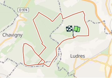
Tour Nordic Walking von 11,8 km verfügbar auf Großer Osten, Mörthe und Mosel, Ludres. Diese Tour wird von DanielROLLET vorgeschlagen.
Beschreibung
2022 02 17 Marche nordique Saulxures Rando 54 - 4 participants
Beau temps mais venteux
Sentiers et chemins gras en forêt (marche ralentie)
Ort
Land:
France
Region :
Großer Osten
Abteilung/Provinz :
Mörthe und Mosel
Kommune :
Ludres
Standort:
Unknown
Gehen Sie:(Dec)
Gehen Sie:(UTM)
290615 ; 5390109 (32U) N.
Kommentare
Touren in der Umgebung
![Tour Zu Fuß Fléville-devant-Nancy - Fléville-devant-Nancy et son château - Photo](https://media.geolcdn.com/t/375/260/ee7686de-cd52-43ca-b6f5-ed4c3a349bb0.jpeg&format=jpg&maxdim=2)
![Zu Fuß Zu Fuß](https://static1.geolcdn.com/sitytour/trail-icons/100.png)
Fléville-devant-Nancy et son château
Zu Fuß
Einfach
Fléville-devant-Nancy,
Großer Osten,
Mörthe und Mosel,
France
![](/images/other/stat-length.png)
7,9 km | 9,4 km-effort
2h 8min
![](https://static1.geolcdn.com/siteimages/upload/files/16400158638029165_repeat_loop_refresh_sync_direction_icon.png)
Ja
![Tour Wandern Bainville-sur-Madon - Bainville sur Madon - Photo](https://media.geolcdn.com/t/375/260/ext.jpg?maxdim=2&url=https%3A%2F%2Fstatic1.geolcdn.com%2Fsiteimages%2Fupload%2Ffiles%2F1553511878bg_sport_marche.png)
![Wandern Wandern](https://static1.geolcdn.com/sitytour/trail-icons/101.png)
Bainville sur Madon
Wandern
Medium
(3)
Bainville-sur-Madon,
Großer Osten,
Mörthe und Mosel,
France
![](/images/other/stat-length.png)
18,3 km | 23 km-effort
4h 15min
![](https://static1.geolcdn.com/siteimages/upload/files/16400158638029165_repeat_loop_refresh_sync_direction_icon.png)
Ja
![Tour Elektrofahrrad Fléville-devant-Nancy - tour dd moselle - Photo](https://media.geolcdn.com/t/375/260/ext.jpg?maxdim=2&url=https%3A%2F%2Fstatic1.geolcdn.com%2Fsiteimages%2Fupload%2Ffiles%2F1524743154velo.jpg)
![Elektrofahrrad Elektrofahrrad](https://static1.geolcdn.com/sitytour/trail-icons/205.png)
tour dd moselle
Elektrofahrrad
Sehr leicht
(1)
Fléville-devant-Nancy,
Großer Osten,
Mörthe und Mosel,
France
![](/images/other/stat-length.png)
45 km | 55 km-effort
3h 0min
![](https://static1.geolcdn.com/siteimages/upload/files/16400158638029165_repeat_loop_refresh_sync_direction_icon.png)
Ja
![Tour sport Ludres - Ludres - Photo](https://media.geolcdn.com/t/375/260/4a41c09b-4979-47d6-9e86-ddd52f153625.jpg&format=jpg&maxdim=2)
Ludres
sport
Sehr leicht
Ludres,
Großer Osten,
Mörthe und Mosel,
France
![](/images/other/stat-length.png)
11,6 km | 14,9 km-effort
Unbekannt
![](https://static1.geolcdn.com/siteimages/upload/files/16400158638029165_repeat_loop_refresh_sync_direction_icon.png)
Ja
![Tour Wandern Ludres - SityTrail - Marche gourmande 11km - Photo](https://media.geolcdn.com/t/375/260/ext.jpg?maxdim=2&url=https%3A%2F%2Fstatic1.geolcdn.com%2Fsiteimages%2Fupload%2Ffiles%2F1553511878bg_sport_marche.png)
![Wandern Wandern](https://static1.geolcdn.com/sitytour/trail-icons/101.png)
SityTrail - Marche gourmande 11km
Wandern
Schwierig
(2)
Ludres,
Großer Osten,
Mörthe und Mosel,
France
![](/images/other/stat-length.png)
10,4 km | 12,1 km-effort
2h 45min
![](https://static1.geolcdn.com/siteimages/upload/files/16400158638029165_repeat_loop_refresh_sync_direction_icon.png)
Ja
![Tour Wandern Vandœuvre-lès-Nancy - Randonnée USEP 2023 - Photo](https://media.geolcdn.com/t/375/260/ext.jpg?maxdim=2&url=https%3A%2F%2Fstatic1.geolcdn.com%2Fsiteimages%2Fupload%2Ffiles%2F1553511878bg_sport_marche.png)
![Wandern Wandern](https://static1.geolcdn.com/sitytour/trail-icons/101.png)
Randonnée USEP 2023
Wandern
Schwierig
(1)
Vandœuvre-lès-Nancy,
Großer Osten,
Mörthe und Mosel,
France
![](/images/other/stat-length.png)
11,7 km | 15,2 km-effort
3h 27min
![](https://static1.geolcdn.com/siteimages/upload/files/16400158638029165_repeat_loop_refresh_sync_direction_icon.png)
Nein
![Tour Wandern Ludres - marche nuit - Photo](https://media.geolcdn.com/t/375/260/2c15af7e-0536-4068-be2b-216477912337.jpg&format=jpg&maxdim=2)
![Wandern Wandern](https://static1.geolcdn.com/sitytour/trail-icons/101.png)
marche nuit
Wandern
Medium
Ludres,
Großer Osten,
Mörthe und Mosel,
France
![](/images/other/stat-length.png)
8,7 km | 10,1 km-effort
2h 11min
![](https://static1.geolcdn.com/siteimages/upload/files/16400158638029165_repeat_loop_refresh_sync_direction_icon.png)
Ja
![Tour Wandern Villers-lès-Nancy - RANDO DUO AVEC ALEXIS - Photo](https://media.geolcdn.com/t/375/260/ext.jpg?maxdim=2&url=https%3A%2F%2Fstatic1.geolcdn.com%2Fsiteimages%2Fupload%2Ffiles%2F1553511878bg_sport_marche.png)
![Wandern Wandern](https://static1.geolcdn.com/sitytour/trail-icons/101.png)
RANDO DUO AVEC ALEXIS
Wandern
Schwierig
(1)
Villers-lès-Nancy,
Großer Osten,
Mörthe und Mosel,
France
![](/images/other/stat-length.png)
38 km | 45 km-effort
10h 19min
![](https://static1.geolcdn.com/siteimages/upload/files/16400158638029165_repeat_loop_refresh_sync_direction_icon.png)
Nein
![Tour Zu Fuß Villers-lès-Nancy - Promenade d'Hardeval - Photo](https://media.geolcdn.com/t/375/260/43cb5da8-59dd-45f8-ae11-ca17f70000c7.jpeg&format=jpg&maxdim=2)
![Zu Fuß Zu Fuß](https://static1.geolcdn.com/sitytour/trail-icons/100.png)
Promenade d'Hardeval
Zu Fuß
Einfach
Villers-lès-Nancy,
Großer Osten,
Mörthe und Mosel,
France
![](/images/other/stat-length.png)
3,2 km | 4,3 km-effort
58min
![](https://static1.geolcdn.com/siteimages/upload/files/16400158638029165_repeat_loop_refresh_sync_direction_icon.png)
Ja