![](/images/other/stat-length.png)
![Tour Zu Fuß Steyregg - Donau-Höhen-Rundwanderweg - Photo](https://media.geolcdn.com/t/1900/400/ext.pjpeg?maxdim=2&url=https%3A%2F%2Fmedia.geolcdn.com%2Ff%2F8ac3dd22-caf0-4c74-be5d-1aa724a2aedc.jpeg)
Donau-Höhen-Rundwanderweg
SityTrail - itinéraires balisés pédestres
Tous les sentiers balisés d’Europe PRO
![Länge](/images/other/stat-length.png)
Länge
3,5 km
![Maximale Höhe](https://static1.geolcdn.com/siteimages/upload/files/1508320355ic_sort_altitude_max_24dp.png)
Maximale Höhe
497 m
![Positive Höhendifferenz](https://static1.geolcdn.com/siteimages/upload/files/1508320355ic_sort_den_pos_24dp.png)
Positive Höhendifferenz
261 m
![Km-Effort](/images/other/stat-length.png)
Km-Effort
6,2 km
![Min. Höhe](https://static1.geolcdn.com/siteimages/upload/files/1508320355ic_sort_altitude_min_24dp.png)
Min. Höhe
244 m
![Negative Höhendifferenz](https://static1.geolcdn.com/siteimages/upload/files/1508320355ic_sort_den_neg_24dp.png)
Negative Höhendifferenz
22 m
![Boucle](https://static1.geolcdn.com/siteimages/upload/files/16400158638029165_repeat_loop_refresh_sync_direction_icon.png)
Boucle
Nein
Kennzeichnung
Erstellungsdatum :
2022-02-16 17:01:49.821
Letzte Änderung :
2022-03-03 15:40:18.44
![Zu Fuß](https://static1.geolcdn.com/sitytour/trail-icons/100.png)
1h24
Schwierigkeit : Einfach
![Scannen Sie diesen QR-Code, um die Tour in der SityTrail-Anwendung zu öffnen](https://capi.geolives.com/qq0zvz2zws4bq2lad0pu/sitytour/trails/3128632/qr.png?size=200)
Kostenlosegpshiking-Anwendung
Über SityTrail
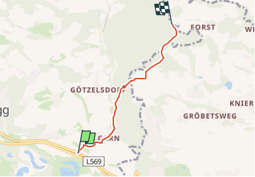
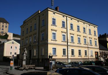
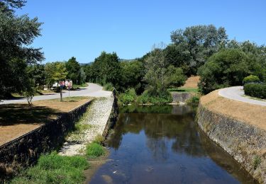
Tour Zu Fuß von 3,5 km verfügbar auf Oberösterreich, Bezirk Urfahr-Umgebung, Steyregg. Diese Tour wird von SityTrail - itinéraires balisés pédestres vorgeschlagen.
Beschreibung
Symbol: Drei horizontale Streifen in den Farben grün (oben), weiß und blau (unten)
Ort
Land:
Austria
Region :
Oberösterreich
Abteilung/Provinz :
Bezirk Urfahr-Umgebung
Kommune :
Steyregg
Standort:
Unknown
Gehen Sie:(Dec)
Gehen Sie:(UTM)
455067 ; 5347423 (33U) N.
Kommentare
Touren in der Umgebung
![Tour Zu Fuß - Bruckner Wanderweg - Photo](https://media.geolcdn.com/t/375/260/ext.jpg?maxdim=2&url=https%3A%2F%2Fmedia.geolcdn.com%2Ff%2F8ed2a067-6cea-44a3-b807-2ba4ea25c498.jpeg)
![Zu Fuß Zu Fuß](https://static1.geolcdn.com/sitytour/trail-icons/100.png)
Bruckner Wanderweg
Zu Fuß
Einfach
,
Oberösterreich,
Linz,
Austria
![](/images/other/stat-length.png)
5,1 km | 6,4 km-effort
1h 27min
![](https://static1.geolcdn.com/siteimages/upload/files/16400158638029165_repeat_loop_refresh_sync_direction_icon.png)
Nein
![Tour Zu Fuß Steyregg - 3 Buchen Weg - Photo](https://media.geolcdn.com/t/375/260/ext.jpg?maxdim=2&url=https%3A%2F%2Fmedia.geolcdn.com%2Ff%2F4bacca63-a8d1-45f1-ab57-007b5153619f.jpeg)
![Zu Fuß Zu Fuß](https://static1.geolcdn.com/sitytour/trail-icons/100.png)
3 Buchen Weg
Zu Fuß
Einfach
Steyregg,
Oberösterreich,
Bezirk Urfahr-Umgebung,
Austria
![](/images/other/stat-length.png)
7,4 km | 12 km-effort
2h 43min
![](https://static1.geolcdn.com/siteimages/upload/files/16400158638029165_repeat_loop_refresh_sync_direction_icon.png)
Nein
![Tour Zu Fuß Steyregg - Pfenningberg-Gipfelwanderweg - Photo](https://media.geolcdn.com/t/375/260/ext.jpg?maxdim=2&url=https%3A%2F%2Fmedia.geolcdn.com%2Ff%2F4bacca63-a8d1-45f1-ab57-007b5153619f.jpeg)
![Zu Fuß Zu Fuß](https://static1.geolcdn.com/sitytour/trail-icons/100.png)
Pfenningberg-Gipfelwanderweg
Zu Fuß
Einfach
Steyregg,
Oberösterreich,
Bezirk Urfahr-Umgebung,
Austria
![](/images/other/stat-length.png)
4,2 km | 8,1 km-effort
1h 50min
![](https://static1.geolcdn.com/siteimages/upload/files/16400158638029165_repeat_loop_refresh_sync_direction_icon.png)
Nein
![Tour Zu Fuß Steyregg - Kreuzweg - Photo](https://media.geolcdn.com/t/375/260/ext.jpg?maxdim=2&url=https%3A%2F%2Fmedia.geolcdn.com%2Ff%2Fa6773d09-7bc7-4e11-8684-0795fb65f2d2.jpeg)
![Zu Fuß Zu Fuß](https://static1.geolcdn.com/sitytour/trail-icons/100.png)
Kreuzweg
Zu Fuß
Einfach
Steyregg,
Oberösterreich,
Bezirk Urfahr-Umgebung,
Austria
![](/images/other/stat-length.png)
3 km | 5,8 km-effort
1h 19min
![](https://static1.geolcdn.com/siteimages/upload/files/16400158638029165_repeat_loop_refresh_sync_direction_icon.png)
Nein
![Tour Zu Fuß Steyregg - AV 50 Daxleitner - Photo](https://media.geolcdn.com/t/375/260/ext.jpg?maxdim=2&url=https%3A%2F%2Fmedia.geolcdn.com%2Ff%2Fac8aab2e-87f4-4c25-ae1f-c0ffc1bf5d02.jpeg)
![Zu Fuß Zu Fuß](https://static1.geolcdn.com/sitytour/trail-icons/100.png)
AV 50 Daxleitner
Zu Fuß
Einfach
Steyregg,
Oberösterreich,
Bezirk Urfahr-Umgebung,
Austria
![](/images/other/stat-length.png)
4,7 km | 8 km-effort
1h 49min
![](https://static1.geolcdn.com/siteimages/upload/files/16400158638029165_repeat_loop_refresh_sync_direction_icon.png)
Nein
![Tour Zu Fuß Steyregg - Stadtwanderweg Pfenningberg - Photo](https://media.geolcdn.com/t/375/260/ext.jpg?maxdim=2&url=https%3A%2F%2Fmedia.geolcdn.com%2Ff%2Fac8aab2e-87f4-4c25-ae1f-c0ffc1bf5d02.jpeg)
![Zu Fuß Zu Fuß](https://static1.geolcdn.com/sitytour/trail-icons/100.png)
Stadtwanderweg Pfenningberg
Zu Fuß
Einfach
Steyregg,
Oberösterreich,
Bezirk Urfahr-Umgebung,
Austria
![](/images/other/stat-length.png)
6,6 km | 10,4 km-effort
2h 22min
![](https://static1.geolcdn.com/siteimages/upload/files/16400158638029165_repeat_loop_refresh_sync_direction_icon.png)
Nein
![Tour Zu Fuß Steyregg - Steyregger Runde - Photo](https://media.geolcdn.com/t/375/260/ext.jpg?maxdim=2&url=https%3A%2F%2Fmedia.geolcdn.com%2Ff%2Fa6773d09-7bc7-4e11-8684-0795fb65f2d2.jpeg)
![Zu Fuß Zu Fuß](https://static1.geolcdn.com/sitytour/trail-icons/100.png)
Steyregger Runde
Zu Fuß
Einfach
Steyregg,
Oberösterreich,
Bezirk Urfahr-Umgebung,
Austria
![](/images/other/stat-length.png)
8,6 km | 12,2 km-effort
2h 47min
![](https://static1.geolcdn.com/siteimages/upload/files/16400158638029165_repeat_loop_refresh_sync_direction_icon.png)
Ja
![Tour Radtourismus Luftenberg an der Donau - Line Grein - Photo](https://media.geolcdn.com/t/375/260/ext.jpg?maxdim=2&url=https%3A%2F%2Fstatic1.geolcdn.com%2Fsiteimages%2Fupload%2Ffiles%2F1524743154velo.jpg)
![Radtourismus Radtourismus](https://static1.geolcdn.com/sitytour/trail-icons/204.png)
Line Grein
Radtourismus
Einfach
Luftenberg an der Donau,
Oberösterreich,
Bezirk Perg,
Austria
![](/images/other/stat-length.png)
54 km | 60 km-effort
5h 53min
![](https://static1.geolcdn.com/siteimages/upload/files/16400158638029165_repeat_loop_refresh_sync_direction_icon.png)
Nein