![](/images/other/stat-length.png)
![Tour Zu Fuß Saalbach-Hinterglemm - Nr. 18 a - Photo](https://media.geolcdn.com/t/1900/400/5443175a-3bd3-4e09-a618-36d5f43df3ac.jpeg&format=pjpeg&maxdim=2)
Nr. 18 a
SityTrail - itinéraires balisés pédestres
Tous les sentiers balisés d’Europe GUIDE+
![Länge](/images/other/stat-length.png)
Länge
6,4 km
![Maximale Höhe](https://static1.geolcdn.com/siteimages/upload/files/1508320355ic_sort_altitude_max_24dp.png)
Maximale Höhe
2009 m
![Positive Höhendifferenz](https://static1.geolcdn.com/siteimages/upload/files/1508320355ic_sort_den_pos_24dp.png)
Positive Höhendifferenz
1 m
![Km-Effort](/images/other/stat-length.png)
Km-Effort
9,9 km
![Min. Höhe](https://static1.geolcdn.com/siteimages/upload/files/1508320355ic_sort_altitude_min_24dp.png)
Min. Höhe
929 m
![Negative Höhendifferenz](https://static1.geolcdn.com/siteimages/upload/files/1508320355ic_sort_den_neg_24dp.png)
Negative Höhendifferenz
1075 m
![Boucle](https://static1.geolcdn.com/siteimages/upload/files/16400158638029165_repeat_loop_refresh_sync_direction_icon.png)
Boucle
Nein
Kennzeichnung
Erstellungsdatum :
2022-02-16 17:00:13.009
Letzte Änderung :
2022-03-03 15:11:36.939
![Zu Fuß](https://static1.geolcdn.com/sitytour/trail-icons/100.png)
2h15
Schwierigkeit : Einfach
![Scannen Sie diesen QR-Code, um die Tour in der SityTrail-Anwendung zu öffnen](https://capi.geolives.com/qq0zvz2zws4bq2lad0pu/sitytour/trails/3128518/qr.png?size=200)
Kostenlosegpshiking-Anwendung
Über SityTrail
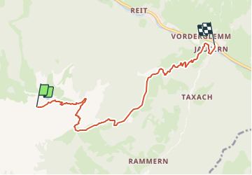
Tour Zu Fuß von 6,4 km verfügbar auf Salzburg, Bezirk Zell am See, Saalbach-Hinterglemm. Diese Tour wird von SityTrail - itinéraires balisés pédestres vorgeschlagen.
Beschreibung
Symbol: roter Grund weißer Strich
Ort
Land:
Austria
Region :
Salzburg
Abteilung/Provinz :
Bezirk Zell am See
Kommune :
Saalbach-Hinterglemm
Standort:
Unknown
Gehen Sie:(Dec)
Gehen Sie:(UTM)
321650 ; 5248723 (33T) N.
Kommentare
Touren in der Umgebung
![Tour Zu Fuß Zell am See - Grafleiten-Tour - Photo](https://media.geolcdn.com/t/375/260/3cf79832-1600-42bf-8fd1-0290aed93239.jpeg&format=jpg&maxdim=2)
![Zu Fuß Zu Fuß](https://static1.geolcdn.com/sitytour/trail-icons/100.png)
Grafleiten-Tour
Zu Fuß
Einfach
Zell am See,
Salzburg,
Bezirk Zell am See,
Austria
![](/images/other/stat-length.png)
3,1 km | 4,9 km-effort
1h 7min
![](https://static1.geolcdn.com/siteimages/upload/files/16400158638029165_repeat_loop_refresh_sync_direction_icon.png)
Nein
![Tour Zu Fuß Zell am See - Hundstein - Photo](https://media.geolcdn.com/t/375/260/106d8961-0004-4662-b4ee-6484e0e3e3bf.jpeg&format=jpg&maxdim=2)
![Zu Fuß Zu Fuß](https://static1.geolcdn.com/sitytour/trail-icons/100.png)
Hundstein
Zu Fuß
Medium
Zell am See,
Salzburg,
Bezirk Zell am See,
Austria
![](/images/other/stat-length.png)
11,9 km | 24 km-effort
5h 28min
![](https://static1.geolcdn.com/siteimages/upload/files/16400158638029165_repeat_loop_refresh_sync_direction_icon.png)
Nein
![Tour Zu Fuß Marktgemeinde Fieberbrunn - Fieberbrunn - Hochkogel - Photo](https://media.geolcdn.com/t/375/260/1092cf09-bbc9-47cc-b619-1816d413fc1a.jpeg&format=jpg&maxdim=2)
![Zu Fuß Zu Fuß](https://static1.geolcdn.com/sitytour/trail-icons/100.png)
Fieberbrunn - Hochkogel
Zu Fuß
Einfach
Marktgemeinde Fieberbrunn,
Tirol,
Bezirk Kitzbühel,
Austria
![](/images/other/stat-length.png)
7,4 km | 11,3 km-effort
2h 34min
![](https://static1.geolcdn.com/siteimages/upload/files/16400158638029165_repeat_loop_refresh_sync_direction_icon.png)
Ja
![Tour Zu Fuß Kaprun - Tauern SPA-Runde - Photo](https://media.geolcdn.com/t/375/260/b49e7ab1-b350-47c3-8757-94a93b9c9af4.jpeg&format=jpg&maxdim=2)
![Zu Fuß Zu Fuß](https://static1.geolcdn.com/sitytour/trail-icons/100.png)
Tauern SPA-Runde
Zu Fuß
Einfach
Kaprun,
Salzburg,
Bezirk Zell am See,
Austria
![](/images/other/stat-length.png)
5,9 km | 6,4 km-effort
1h 26min
![](https://static1.geolcdn.com/siteimages/upload/files/16400158638029165_repeat_loop_refresh_sync_direction_icon.png)
Ja
![Tour Zu Fuß Marktgemeinde Fieberbrunn - [12] Fieberbrunn Jägersteig - Photo](https://media.geolcdn.com/t/375/260/9edda448-f93a-4af8-b4d9-b9ec1461bad0.jpeg&format=jpg&maxdim=2)
![Zu Fuß Zu Fuß](https://static1.geolcdn.com/sitytour/trail-icons/100.png)
[12] Fieberbrunn Jägersteig
Zu Fuß
Einfach
Marktgemeinde Fieberbrunn,
Tirol,
Bezirk Kitzbühel,
Austria
![](/images/other/stat-length.png)
4,5 km | 8,6 km-effort
1h 57min
![](https://static1.geolcdn.com/siteimages/upload/files/16400158638029165_repeat_loop_refresh_sync_direction_icon.png)
Nein
![Tour Zu Fuß Marktgemeinde Fieberbrunn - [18] Fieberbrunn - Blumenweg - Photo](https://media.geolcdn.com/t/375/260/b0fb6c51-bb1d-48af-8466-686aec3e3c44.jpeg&format=jpg&maxdim=2)
![Zu Fuß Zu Fuß](https://static1.geolcdn.com/sitytour/trail-icons/100.png)
[18] Fieberbrunn - Blumenweg
Zu Fuß
Einfach
Marktgemeinde Fieberbrunn,
Tirol,
Bezirk Kitzbühel,
Austria
![](/images/other/stat-length.png)
4,5 km | 7 km-effort
1h 36min
![](https://static1.geolcdn.com/siteimages/upload/files/16400158638029165_repeat_loop_refresh_sync_direction_icon.png)
Nein
![Tour Zu Fuß Marktgemeinde Fieberbrunn - [2] Fieberbrunner Höhenweg - Photo](https://media.geolcdn.com/t/375/260/e8040533-add9-44ec-957a-500c7078819f.jpeg&format=jpg&maxdim=2)
![Zu Fuß Zu Fuß](https://static1.geolcdn.com/sitytour/trail-icons/100.png)
[2] Fieberbrunner Höhenweg
Zu Fuß
Schwierig
Marktgemeinde Fieberbrunn,
Tirol,
Bezirk Kitzbühel,
Austria
![](/images/other/stat-length.png)
24 km | 37 km-effort
8h 18min
![](https://static1.geolcdn.com/siteimages/upload/files/16400158638029165_repeat_loop_refresh_sync_direction_icon.png)
Nein
![Tour Zu Fuß Marktgemeinde Fieberbrunn - [1] Fieberbrunn - Wanderschuh - Photo](https://media.geolcdn.com/t/375/260/fd03419b-07ff-495d-9845-bd674901fd7c.jpeg&format=jpg&maxdim=2)
![Zu Fuß Zu Fuß](https://static1.geolcdn.com/sitytour/trail-icons/100.png)
[1] Fieberbrunn - Wanderschuh
Zu Fuß
Einfach
Marktgemeinde Fieberbrunn,
Tirol,
Bezirk Kitzbühel,
Austria
![](/images/other/stat-length.png)
3,2 km | 4,3 km-effort
58min
![](https://static1.geolcdn.com/siteimages/upload/files/16400158638029165_repeat_loop_refresh_sync_direction_icon.png)
Nein
![Tour Zu Fuß Marktgemeinde Fieberbrunn - [3] Fieberbrunn - Karstein - Photo](https://media.geolcdn.com/t/375/260/3deaf227-084c-4bb2-b343-4239f2614f36.jpeg&format=jpg&maxdim=2)
![Zu Fuß Zu Fuß](https://static1.geolcdn.com/sitytour/trail-icons/100.png)
[3] Fieberbrunn - Karstein
Zu Fuß
Schwierig
Marktgemeinde Fieberbrunn,
Tirol,
Bezirk Kitzbühel,
Austria
![](/images/other/stat-length.png)
22 km | 38 km-effort
8h 32min
![](https://static1.geolcdn.com/siteimages/upload/files/16400158638029165_repeat_loop_refresh_sync_direction_icon.png)
Ja