![](/images/other/stat-length.png)
![Tour Zu Fuß Iwonitz-Bad - Rymanów Zdrój - Iwonicz Zdrój - Photo](https://media.geolcdn.com/t/1900/400/8eb1bf63-71fa-4f20-8bb7-82b0468656b1.jpeg&format=pjpeg&maxdim=2)
Rymanów Zdrój - Iwonicz Zdrój
SityTrail - itinéraires balisés pédestres
Tous les sentiers balisés d’Europe GUIDE+
![Länge](/images/other/stat-length.png)
Länge
5,3 km
![Maximale Höhe](https://static1.geolcdn.com/siteimages/upload/files/1508320355ic_sort_altitude_max_24dp.png)
Maximale Höhe
623 m
![Positive Höhendifferenz](https://static1.geolcdn.com/siteimages/upload/files/1508320355ic_sort_den_pos_24dp.png)
Positive Höhendifferenz
196 m
![Km-Effort](/images/other/stat-length.png)
Km-Effort
8,1 km
![Min. Höhe](https://static1.geolcdn.com/siteimages/upload/files/1508320355ic_sort_altitude_min_24dp.png)
Min. Höhe
382 m
![Negative Höhendifferenz](https://static1.geolcdn.com/siteimages/upload/files/1508320355ic_sort_den_neg_24dp.png)
Negative Höhendifferenz
242 m
![Boucle](https://static1.geolcdn.com/siteimages/upload/files/16400158638029165_repeat_loop_refresh_sync_direction_icon.png)
Boucle
Nein
Kennzeichnung
Erstellungsdatum :
2022-02-16 16:43:43.786
Letzte Änderung :
2022-03-08 12:45:42.713
![Zu Fuß](https://static1.geolcdn.com/sitytour/trail-icons/100.png)
1h50
Schwierigkeit : Einfach
![Scannen Sie diesen QR-Code, um die Tour in der SityTrail-Anwendung zu öffnen](https://capi.geolives.com/qq0zvz2zws4bq2lad0pu/sitytour/trails/3127669/qr.png?size=200)
Kostenlosegpshiking-Anwendung
Über SityTrail
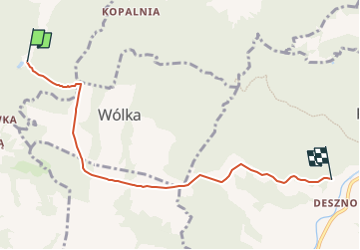
Tour Zu Fuß von 5,3 km verfügbar auf Woiwodschaft Karpatenvorland, powiat krośnieński, Iwonitz-Bad. Diese Tour wird von SityTrail - itinéraires balisés pédestres vorgeschlagen.
Beschreibung
Website: http://www.szlaki-beskid.klikklik.pl/szlaki/szlaki_gminne_inne/szlak_rymanow_przymiarki_iwonicz.php
Ort
Land:
Poland
Region :
Woiwodschaft Karpatenvorland
Abteilung/Provinz :
powiat krośnieński
Kommune :
Iwonitz-Bad
Standort:
Unknown
Gehen Sie:(Dec)
Gehen Sie:(UTM)
556797 ; 5489503 (34U) N.
Kommentare
Touren in der Umgebung
![Tour Zu Fuß Rymanów-Zdrój - Trasa Fitness - Photo](https://media.geolcdn.com/t/375/260/dbff1d05-3902-4857-bca6-222a0b51bd9d.jpeg&format=jpg&maxdim=2)
![Zu Fuß Zu Fuß](https://static1.geolcdn.com/sitytour/trail-icons/100.png)
Trasa Fitness
Zu Fuß
Einfach
Rymanów-Zdrój,
Woiwodschaft Karpatenvorland,
powiat krośnieński,
Poland
![](/images/other/stat-length.png)
4 km | 5,9 km-effort
1h 20min
![](https://static1.geolcdn.com/siteimages/upload/files/16400158638029165_repeat_loop_refresh_sync_direction_icon.png)
Nein
![Tour Zu Fuß Rymanów-Zdrój - Ścieżka przyrodnicza Rymanów Zdrój - Photo](https://media.geolcdn.com/t/375/260/36ed06ea-ab8f-46e8-9bd6-9eb4ffed6860.jpeg&format=jpg&maxdim=2)
![Zu Fuß Zu Fuß](https://static1.geolcdn.com/sitytour/trail-icons/100.png)
Ścieżka przyrodnicza Rymanów Zdrój
Zu Fuß
Einfach
Rymanów-Zdrój,
Woiwodschaft Karpatenvorland,
powiat krośnieński,
Poland
![](/images/other/stat-length.png)
8,2 km | 12,6 km-effort
2h 52min
![](https://static1.geolcdn.com/siteimages/upload/files/16400158638029165_repeat_loop_refresh_sync_direction_icon.png)
Ja