![](/images/other/stat-length.png)
![Tour Zu Fuß Birkfeld - Schusterklammsteig - Photo](https://media.geolcdn.com/t/1900/400/ext.pjpeg?maxdim=2&url=https%3A%2F%2Fstatic1.geolcdn.com%2Fsiteimages%2Fupload%2Ffiles%2F1545311037marcheuse_200dpi.jpg)
Schusterklammsteig
SityTrail - itinéraires balisés pédestres
Tous les sentiers balisés d’Europe PRO
![Länge](/images/other/stat-length.png)
Länge
7,2 km
![Maximale Höhe](https://static1.geolcdn.com/siteimages/upload/files/1508320355ic_sort_altitude_max_24dp.png)
Maximale Höhe
1096 m
![Positive Höhendifferenz](https://static1.geolcdn.com/siteimages/upload/files/1508320355ic_sort_den_pos_24dp.png)
Positive Höhendifferenz
350 m
![Km-Effort](/images/other/stat-length.png)
Km-Effort
11,9 km
![Min. Höhe](https://static1.geolcdn.com/siteimages/upload/files/1508320355ic_sort_altitude_min_24dp.png)
Min. Höhe
787 m
![Negative Höhendifferenz](https://static1.geolcdn.com/siteimages/upload/files/1508320355ic_sort_den_neg_24dp.png)
Negative Höhendifferenz
356 m
![Boucle](https://static1.geolcdn.com/siteimages/upload/files/16400158638029165_repeat_loop_refresh_sync_direction_icon.png)
Boucle
Ja
Kennzeichnung
Erstellungsdatum :
2022-02-16 16:10:57.003
Letzte Änderung :
2022-03-03 03:12:55.345
![Zu Fuß](https://static1.geolcdn.com/sitytour/trail-icons/100.png)
2h42
Schwierigkeit : Einfach
![Scannen Sie diesen QR-Code, um die Tour in der SityTrail-Anwendung zu öffnen](https://capi.geolives.com/qq0zvz2zws4bq2lad0pu/sitytour/trails/3126261/qr.png?size=200)
Kostenlosegpshiking-Anwendung
Über SityTrail
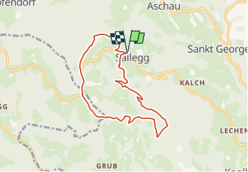
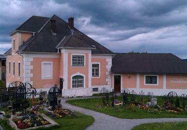
Tour Zu Fuß von 7,2 km verfügbar auf Steiermark, Bezirk Weiz, Birkfeld. Diese Tour wird von SityTrail - itinéraires balisés pédestres vorgeschlagen.
Beschreibung
Trail created by Almenland.
http://www.almenland.net/download/Schusterklammsteig.pdf
Symbol: rot-weiss-rot 20
Ort
Land:
Austria
Region :
Steiermark
Abteilung/Provinz :
Bezirk Weiz
Kommune :
Birkfeld
Standort:
Unknown
Gehen Sie:(Dec)
Gehen Sie:(UTM)
549877 ; 5243036 (33T) N.
Kommentare
Touren in der Umgebung
![Tour Zu Fuß Birkfeld - Wanderweg 10 - Photo](https://media.geolcdn.com/t/375/260/ext.jpg?maxdim=2&url=https%3A%2F%2Fmedia.geolcdn.com%2Ff%2Ff1bec0a1-9b37-4596-89cf-8d56c2301767.jpeg)
![Zu Fuß Zu Fuß](https://static1.geolcdn.com/sitytour/trail-icons/100.png)
Wanderweg 10
Zu Fuß
Einfach
Birkfeld,
Steiermark,
Bezirk Weiz,
Austria
![](/images/other/stat-length.png)
3 km | 4,8 km-effort
1h 5min
![](https://static1.geolcdn.com/siteimages/upload/files/16400158638029165_repeat_loop_refresh_sync_direction_icon.png)
Nein
![Tour Zu Fuß Strallegg - Hoamatweg - Photo](https://media.geolcdn.com/t/375/260/ext.jpg?maxdim=2&url=https%3A%2F%2Fmedia.geolcdn.com%2Ff%2Ff1bec0a1-9b37-4596-89cf-8d56c2301767.jpeg)
![Zu Fuß Zu Fuß](https://static1.geolcdn.com/sitytour/trail-icons/100.png)
Hoamatweg
Zu Fuß
Einfach
Strallegg,
Steiermark,
Bezirk Weiz,
Austria
![](/images/other/stat-length.png)
12,4 km | 18,3 km-effort
4h 9min
![](https://static1.geolcdn.com/siteimages/upload/files/16400158638029165_repeat_loop_refresh_sync_direction_icon.png)
Nein
![Tour Zu Fuß Birkfeld - Genussrundwanderweg Koglhof - Sallegg - Photo](https://media.geolcdn.com/t/375/260/ext.jpg?maxdim=2&url=https%3A%2F%2Fmedia.geolcdn.com%2Ff%2F6e328e73-808d-41e0-bba2-00452ae3450b.jpeg)
![Zu Fuß Zu Fuß](https://static1.geolcdn.com/sitytour/trail-icons/100.png)
Genussrundwanderweg Koglhof - Sallegg
Zu Fuß
Einfach
Birkfeld,
Steiermark,
Bezirk Weiz,
Austria
![](/images/other/stat-length.png)
11 km | 17,9 km-effort
4h 3min
![](https://static1.geolcdn.com/siteimages/upload/files/16400158638029165_repeat_loop_refresh_sync_direction_icon.png)
Ja
![Tour Zu Fuß Birkfeld - Wanderweg 64 - Photo](https://media.geolcdn.com/t/375/260/ext.jpg?maxdim=2&url=https%3A%2F%2Fmedia.geolcdn.com%2Ff%2Fc531ada1-463f-46ac-be91-c3156665ac97.jpeg)
![Zu Fuß Zu Fuß](https://static1.geolcdn.com/sitytour/trail-icons/100.png)
Wanderweg 64
Zu Fuß
Einfach
Birkfeld,
Steiermark,
Bezirk Weiz,
Austria
![](/images/other/stat-length.png)
10,3 km | 18,7 km-effort
4h 14min
![](https://static1.geolcdn.com/siteimages/upload/files/16400158638029165_repeat_loop_refresh_sync_direction_icon.png)
Nein
![Tour Zu Fuß St. Kathrein am Offenegg - Mühlentalrundweg - Photo](https://media.geolcdn.com/t/375/260/ext.jpg?maxdim=2&url=https%3A%2F%2Fmedia.geolcdn.com%2Ff%2Fa9b64dd0-a459-4a1f-8761-75f4629db48f.jpeg)
![Zu Fuß Zu Fuß](https://static1.geolcdn.com/sitytour/trail-icons/100.png)
Mühlentalrundweg
Zu Fuß
Einfach
St. Kathrein am Offenegg,
Steiermark,
Bezirk Weiz,
Austria
![](/images/other/stat-length.png)
4,6 km | 6,1 km-effort
1h 23min
![](https://static1.geolcdn.com/siteimages/upload/files/16400158638029165_repeat_loop_refresh_sync_direction_icon.png)
Nein
![Tour Zu Fuß Birkfeld - Koenigskogel Rundweg - Photo](https://media.geolcdn.com/t/375/260/ext.jpg?maxdim=2&url=https%3A%2F%2Fstatic1.geolcdn.com%2Fsiteimages%2Fupload%2Ffiles%2F1545311037marcheuse_200dpi.jpg)
![Zu Fuß Zu Fuß](https://static1.geolcdn.com/sitytour/trail-icons/100.png)
Koenigskogel Rundweg
Zu Fuß
Einfach
Birkfeld,
Steiermark,
Bezirk Weiz,
Austria
![](/images/other/stat-length.png)
8,9 km | 13,2 km-effort
2h 59min
![](https://static1.geolcdn.com/siteimages/upload/files/16400158638029165_repeat_loop_refresh_sync_direction_icon.png)
Ja