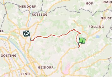
![](/images/other/stat-length.png)
![Tour Zu Fuß Unbekannt - Wanderweg 85 - Photo](https://media.geolcdn.com/t/1900/400/ceb76f37-f7f2-4c63-8e64-2993e6699182.jpeg&format=pjpeg&maxdim=2)
Wanderweg 85
SityTrail - itinéraires balisés pédestres
Tous les sentiers balisés d’Europe GUIDE+
![Länge](/images/other/stat-length.png)
![Maximale Höhe](https://static1.geolcdn.com/siteimages/upload/files/1508320355ic_sort_altitude_max_24dp.png)
![Positive Höhendifferenz](https://static1.geolcdn.com/siteimages/upload/files/1508320355ic_sort_den_pos_24dp.png)
![Km-Effort](/images/other/stat-length.png)
![Min. Höhe](https://static1.geolcdn.com/siteimages/upload/files/1508320355ic_sort_altitude_min_24dp.png)
![Negative Höhendifferenz](https://static1.geolcdn.com/siteimages/upload/files/1508320355ic_sort_den_neg_24dp.png)
![Boucle](https://static1.geolcdn.com/siteimages/upload/files/16400158638029165_repeat_loop_refresh_sync_direction_icon.png)
![Zu Fuß](https://static1.geolcdn.com/sitytour/trail-icons/100.png)
2h25
Schwierigkeit : Einfach
![Scannen Sie diesen QR-Code, um die Tour in der SityTrail-Anwendung zu öffnen](https://capi.geolives.com/qq0zvz2zws4bq2lad0pu/sitytour/trails/3125937/qr.png?size=200)
Kostenlosegpshiking-Anwendung
Über SityTrail
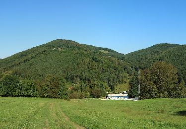
Tour Zu Fuß von 7 km verfügbar auf Steiermark, Graz, Unbekannt. Diese Tour wird von SityTrail - itinéraires balisés pédestres vorgeschlagen.
Beschreibung
Trail created by Österreichischer Alpenverein, Sektion Graz.
http://wiki.openstreetmap.org/wiki/WikiProject_Austria/Wanderwege
Symbol: rot-weiss-rot mit schwarzer Zahl 85 im weissen Streifen
Ort
Kommentare
Touren in der Umgebung
![Tour Zu Fuß Unbekannt - Wanderweg 6 - Photo](https://media.geolcdn.com/t/375/260/ef4bff11-ad71-42b5-a210-0da5eab0a04b.jpeg&format=jpg&maxdim=2)
![Zu Fuß Zu Fuß](https://static1.geolcdn.com/sitytour/trail-icons/100.png)
Zu Fuß
![](/images/other/stat-length.png)
![](https://static1.geolcdn.com/siteimages/upload/files/16400158638029165_repeat_loop_refresh_sync_direction_icon.png)
![Tour Zu Fuß Unbekannt - Wanderweg 85a - Photo](https://media.geolcdn.com/t/375/260/7565fbd9-0187-4b54-b282-25afaef0c024.jpeg&format=jpg&maxdim=2)
![Zu Fuß Zu Fuß](https://static1.geolcdn.com/sitytour/trail-icons/100.png)
Zu Fuß
![](/images/other/stat-length.png)
![](https://static1.geolcdn.com/siteimages/upload/files/16400158638029165_repeat_loop_refresh_sync_direction_icon.png)
![Tour Zu Fuß Unbekannt - Wanderweg 5 - Photo](https://media.geolcdn.com/t/375/260/0f090025-5e43-4bc7-952b-186de3ca82e0.jpeg&format=jpg&maxdim=2)
![Zu Fuß Zu Fuß](https://static1.geolcdn.com/sitytour/trail-icons/100.png)
Zu Fuß
![](/images/other/stat-length.png)
![](https://static1.geolcdn.com/siteimages/upload/files/16400158638029165_repeat_loop_refresh_sync_direction_icon.png)
![Tour Zu Fuß Unbekannt - Wanderweg 10 - Photo](https://media.geolcdn.com/t/375/260/2b9ddd0c-abce-4077-ae0b-0ca226a8ce92.jpeg&format=jpg&maxdim=2)
![Zu Fuß Zu Fuß](https://static1.geolcdn.com/sitytour/trail-icons/100.png)
Zu Fuß
![](/images/other/stat-length.png)
![](https://static1.geolcdn.com/siteimages/upload/files/16400158638029165_repeat_loop_refresh_sync_direction_icon.png)
![Tour Zu Fuß Kumberg - Wanderweg 24 - Photo](https://media.geolcdn.com/t/375/260/9bc96c69-54e4-471d-af29-1921cd29561d.jpeg&format=jpg&maxdim=2)
![Zu Fuß Zu Fuß](https://static1.geolcdn.com/sitytour/trail-icons/100.png)
Zu Fuß
![](/images/other/stat-length.png)
![](https://static1.geolcdn.com/siteimages/upload/files/16400158638029165_repeat_loop_refresh_sync_direction_icon.png)
![Tour Zu Fuß Stattegg - Wanderweg 20 - Photo](https://media.geolcdn.com/t/375/260/35c66279-7294-45a4-9823-4a30f14c908e.jpeg&format=jpg&maxdim=2)
![Zu Fuß Zu Fuß](https://static1.geolcdn.com/sitytour/trail-icons/100.png)
Zu Fuß
![](/images/other/stat-length.png)
![](https://static1.geolcdn.com/siteimages/upload/files/16400158638029165_repeat_loop_refresh_sync_direction_icon.png)
![Tour Zu Fuß Unbekannt - Wanderweg 80 - Photo](https://media.geolcdn.com/t/375/260/1162451f-37a2-49c1-ad04-5b377cccdc25.jpeg&format=jpg&maxdim=2)
![Zu Fuß Zu Fuß](https://static1.geolcdn.com/sitytour/trail-icons/100.png)
Zu Fuß
![](/images/other/stat-length.png)
![](https://static1.geolcdn.com/siteimages/upload/files/16400158638029165_repeat_loop_refresh_sync_direction_icon.png)
![Tour Zu Fuß Stattegg - Wanderweg 26 - Photo](https://media.geolcdn.com/t/375/260/1b9766c4-f1c0-4ef5-8d6e-9630c9983cd1.jpeg&format=jpg&maxdim=2)
![Zu Fuß Zu Fuß](https://static1.geolcdn.com/sitytour/trail-icons/100.png)
Zu Fuß
![](/images/other/stat-length.png)
![](https://static1.geolcdn.com/siteimages/upload/files/16400158638029165_repeat_loop_refresh_sync_direction_icon.png)
![Tour Zu Fuß Weinitzen - Wanderweg 25 - Photo](https://media.geolcdn.com/t/375/260/bb3f6aac-2f27-41c7-b3c9-5f421fcf1a2d.jpeg&format=jpg&maxdim=2)
![Zu Fuß Zu Fuß](https://static1.geolcdn.com/sitytour/trail-icons/100.png)
Zu Fuß
![](/images/other/stat-length.png)
![](https://static1.geolcdn.com/siteimages/upload/files/16400158638029165_repeat_loop_refresh_sync_direction_icon.png)