![](/images/other/stat-length.png)
![Tour Wandern Martinet - martinet-beaulieu sentier du jaunay - Photo](https://media.geolcdn.com/t/1900/400/ext.pjpeg?maxdim=2&url=https%3A%2F%2Fstatic1.geolcdn.com%2Fsiteimages%2Fupload%2Ffiles%2F1553511878bg_sport_marche.png)
martinet-beaulieu sentier du jaunay
crepero
Benutzer
![Länge](/images/other/stat-length.png)
Länge
19,8 km
![Maximale Höhe](https://static1.geolcdn.com/siteimages/upload/files/1508320355ic_sort_altitude_max_24dp.png)
Maximale Höhe
62 m
![Positive Höhendifferenz](https://static1.geolcdn.com/siteimages/upload/files/1508320355ic_sort_den_pos_24dp.png)
Positive Höhendifferenz
182 m
![Km-Effort](/images/other/stat-length.png)
Km-Effort
22 km
![Min. Höhe](https://static1.geolcdn.com/siteimages/upload/files/1508320355ic_sort_altitude_min_24dp.png)
Min. Höhe
17 m
![Negative Höhendifferenz](https://static1.geolcdn.com/siteimages/upload/files/1508320355ic_sort_den_neg_24dp.png)
Negative Höhendifferenz
182 m
![Boucle](https://static1.geolcdn.com/siteimages/upload/files/16400158638029165_repeat_loop_refresh_sync_direction_icon.png)
Boucle
Ja
Erstellungsdatum :
2014-12-10 00:00:00.0
Letzte Änderung :
2014-12-10 00:00:00.0
![Wandern](https://static1.geolcdn.com/sitytour/trail-icons/101.png)
4h30
Schwierigkeit : Einfach
![Scannen Sie diesen QR-Code, um die Tour in der SityTrail-Anwendung zu öffnen](https://capi.geolives.com/qq0zvz2zws4bq2lad0pu/sitytour/trails/312428/qr.png?size=200)
Kostenlosegpshiking-Anwendung
Über SityTrail
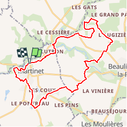
Tour Wandern von 19,8 km verfügbar auf Pays de la Loire, Vendée, Martinet. Diese Tour wird von crepero vorgeschlagen.
Beschreibung
au depart de martinet suivre le sentier des chênes lièges couleur violet et par les liaisons recuperer le sentier du jaunay (beaulieu sous la roche)de couleur vert pour revenir en boucle vers le sentier des chênes lièges.
Ort
Land:
France
Region :
Pays de la Loire
Abteilung/Provinz :
Vendée
Kommune :
Martinet
Standort:
Unknown
Gehen Sie:(Dec)
Gehen Sie:(UTM)
601043 ; 5170577 (30T) N.
Kommentare
Touren in der Umgebung
![Tour Fahrrad Martinet - Martinet Saint gilles Martinet - Photo](https://media.geolcdn.com/t/375/260/ext.jpg?maxdim=2&url=https%3A%2F%2Fstatic1.geolcdn.com%2Fsiteimages%2Fupload%2Ffiles%2F1524743154velo.jpg)
![Fahrrad Fahrrad](https://static1.geolcdn.com/sitytour/trail-icons/200.png)
Martinet Saint gilles Martinet
Fahrrad
Einfach
(1)
Martinet,
Pays de la Loire,
Vendée,
France
![](/images/other/stat-length.png)
25 km | 28 km-effort
1h 37min
![](https://static1.geolcdn.com/siteimages/upload/files/16400158638029165_repeat_loop_refresh_sync_direction_icon.png)
Nein
![Tour Wandern Beaulieu-sous-la-Roche - La Vacherie La Boëre - Photo](https://media.geolcdn.com/t/375/260/ext.jpg?maxdim=2&url=https%3A%2F%2Fstatic1.geolcdn.com%2Fsiteimages%2Fupload%2Ffiles%2F1553511878bg_sport_marche.png)
![Wandern Wandern](https://static1.geolcdn.com/sitytour/trail-icons/101.png)
La Vacherie La Boëre
Wandern
Einfach
(1)
Beaulieu-sous-la-Roche,
Pays de la Loire,
Vendée,
France
![](/images/other/stat-length.png)
13 km | 14,5 km-effort
3h 11min
![](https://static1.geolcdn.com/siteimages/upload/files/16400158638029165_repeat_loop_refresh_sync_direction_icon.png)
Ja
![Tour Wandern Saint-Georges-de-Pointindoux - St Georges Moulières Gilardière - Photo](https://media.geolcdn.com/t/375/260/ext.jpg?maxdim=2&url=https%3A%2F%2Fstatic1.geolcdn.com%2Fsiteimages%2Fupload%2Ffiles%2F1553511878bg_sport_marche.png)
![Wandern Wandern](https://static1.geolcdn.com/sitytour/trail-icons/101.png)
St Georges Moulières Gilardière
Wandern
Einfach
(1)
Saint-Georges-de-Pointindoux,
Pays de la Loire,
Vendée,
France
![](/images/other/stat-length.png)
12,3 km | 13,6 km-effort
3h 0min
![](https://static1.geolcdn.com/siteimages/upload/files/16400158638029165_repeat_loop_refresh_sync_direction_icon.png)
Ja
![Tour Nordic Walking Martinet - autour du garreau - Photo](https://media.geolcdn.com/t/375/260/ext.jpg?maxdim=2&url=https%3A%2F%2Fstatic1.geolcdn.com%2Fsiteimages%2Fupload%2Ffiles%2F1545311037marcheuse_200dpi.jpg)
![Nordic Walking Nordic Walking](https://static1.geolcdn.com/sitytour/trail-icons/102.png)
autour du garreau
Nordic Walking
Einfach
(1)
Martinet,
Pays de la Loire,
Vendée,
France
![](/images/other/stat-length.png)
16,4 km | 17,8 km-effort
6min
![](https://static1.geolcdn.com/siteimages/upload/files/16400158638029165_repeat_loop_refresh_sync_direction_icon.png)
Ja
![Tour Wandern Martinet - martinet 1bis - Photo](https://media.geolcdn.com/t/375/260/ext.jpg?maxdim=2&url=https%3A%2F%2Fservices.sitytrail.com%2FGeolivesWS%2FDownloadMedia.ashx%3FTrailID%3D310902%26Media%3Dfix__20140609162439.jpg)
![Wandern Wandern](https://static1.geolcdn.com/sitytour/trail-icons/101.png)
martinet 1bis
Wandern
Einfach
Martinet,
Pays de la Loire,
Vendée,
France
![](/images/other/stat-length.png)
15,7 km | 17,3 km-effort
3h 18min
![](https://static1.geolcdn.com/siteimages/upload/files/16400158638029165_repeat_loop_refresh_sync_direction_icon.png)
Ja
![Tour Mountainbike Martinet - martinet Beaulieu - Photo](https://media.geolcdn.com/t/375/260/ext.jpg?maxdim=2&url=https%3A%2F%2Fstatic1.geolcdn.com%2Fsiteimages%2Fupload%2Ffiles%2F1524743154velo.jpg)
![Mountainbike Mountainbike](https://static1.geolcdn.com/sitytour/trail-icons/202.png)
martinet Beaulieu
Mountainbike
Einfach
Martinet,
Pays de la Loire,
Vendée,
France
![](/images/other/stat-length.png)
15,4 km | 16,7 km-effort
1h 30min
![](https://static1.geolcdn.com/siteimages/upload/files/16400158638029165_repeat_loop_refresh_sync_direction_icon.png)
Ja
![Tour Mountainbike Aizenay - 2021/07/18 Coex vers Mouilleron - Photo](https://media.geolcdn.com/t/375/260/ext.jpg?maxdim=2&url=https%3A%2F%2Fstatic1.geolcdn.com%2Fsiteimages%2Fupload%2Ffiles%2F1524743154velo.jpg)
![Mountainbike Mountainbike](https://static1.geolcdn.com/sitytour/trail-icons/202.png)
2021/07/18 Coex vers Mouilleron
Mountainbike
Medium
Aizenay,
Pays de la Loire,
Vendée,
France
![](/images/other/stat-length.png)
20 km | 22 km-effort
1h 3min
![](https://static1.geolcdn.com/siteimages/upload/files/16400158638029165_repeat_loop_refresh_sync_direction_icon.png)
Nein
![Tour Wandern Saint-Georges-de-Pointindoux - Saint Georges de pointindoux - Photo](https://media.geolcdn.com/t/375/260/ext.jpg?maxdim=2&url=https%3A%2F%2Fstatic1.geolcdn.com%2Fsiteimages%2Fupload%2Ffiles%2F1553511878bg_sport_marche.png)
![Wandern Wandern](https://static1.geolcdn.com/sitytour/trail-icons/101.png)
Saint Georges de pointindoux
Wandern
Sehr leicht
Saint-Georges-de-Pointindoux,
Pays de la Loire,
Vendée,
France
![](/images/other/stat-length.png)
13,8 km | 15,1 km-effort
3h 8min
![](https://static1.geolcdn.com/siteimages/upload/files/16400158638029165_repeat_loop_refresh_sync_direction_icon.png)
Ja
![Tour Wandern Saint-Georges-de-Pointindoux - st Georges de point indium (85) - Photo](https://media.geolcdn.com/t/375/260/ext.jpg?maxdim=2&url=https%3A%2F%2Fservices.sitytrail.com%2FGeolivesWS%2FDownloadMedia.ashx%3FTrailID%3D859774%26Media%3D20171109145508.jpg)
![Wandern Wandern](https://static1.geolcdn.com/sitytour/trail-icons/101.png)
st Georges de point indium (85)
Wandern
Sehr leicht
Saint-Georges-de-Pointindoux,
Pays de la Loire,
Vendée,
France
![](/images/other/stat-length.png)
23 km | 25 km-effort
5h 38min
![](https://static1.geolcdn.com/siteimages/upload/files/16400158638029165_repeat_loop_refresh_sync_direction_icon.png)
Ja