![](/images/other/stat-length.png)
![Tour Zu Fuß La Couyère - La ronde des espiègles - Photo](https://media.geolcdn.com/t/1900/400/ext.pjpeg?maxdim=2&url=https%3A%2F%2Fmedia.geolcdn.com%2Ff%2F8749dcd4-6beb-4da2-9e16-c014ea5c733d.jpeg)
La ronde des espiègles
SityTrail - itinéraires balisés pédestres
Tous les sentiers balisés d’Europe PRO
![Länge](/images/other/stat-length.png)
Länge
14,3 km
![Maximale Höhe](https://static1.geolcdn.com/siteimages/upload/files/1508320355ic_sort_altitude_max_24dp.png)
Maximale Höhe
107 m
![Positive Höhendifferenz](https://static1.geolcdn.com/siteimages/upload/files/1508320355ic_sort_den_pos_24dp.png)
Positive Höhendifferenz
150 m
![Km-Effort](/images/other/stat-length.png)
Km-Effort
16,3 km
![Min. Höhe](https://static1.geolcdn.com/siteimages/upload/files/1508320355ic_sort_altitude_min_24dp.png)
Min. Höhe
45 m
![Negative Höhendifferenz](https://static1.geolcdn.com/siteimages/upload/files/1508320355ic_sort_den_neg_24dp.png)
Negative Höhendifferenz
150 m
![Boucle](https://static1.geolcdn.com/siteimages/upload/files/16400158638029165_repeat_loop_refresh_sync_direction_icon.png)
Boucle
Ja
Kennzeichnung
Erstellungsdatum :
2022-02-15 19:02:09.37
Letzte Änderung :
2022-03-02 22:36:50.317
![Zu Fuß](https://static1.geolcdn.com/sitytour/trail-icons/100.png)
3h42
Schwierigkeit : Einfach
![Scannen Sie diesen QR-Code, um die Tour in der SityTrail-Anwendung zu öffnen](https://capi.geolives.com/qq0zvz2zws4bq2lad0pu/sitytour/trails/3124208/qr.png?size=200)
Kostenlosegpshiking-Anwendung
Über SityTrail
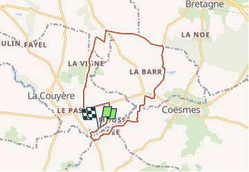
Tour Zu Fuß von 14,3 km verfügbar auf Bretagne, Ille-et-Vilaine, La Couyère. Diese Tour wird von SityTrail - itinéraires balisés pédestres vorgeschlagen.
Beschreibung
Trail created by Roche aux fées Communauté.
Ort
Land:
France
Region :
Bretagne
Abteilung/Provinz :
Ille-et-Vilaine
Kommune :
La Couyère
Standort:
Unknown
Gehen Sie:(Dec)
Gehen Sie:(UTM)
613547 ; 5303715 (30T) N.
Kommentare
Touren in der Umgebung
![Tour Zu Fuß Coësmes - Chemin des Saulniers - Photo](https://media.geolcdn.com/t/375/260/ext.jpg?maxdim=2&url=https%3A%2F%2Fmedia.geolcdn.com%2Ff%2F4b5ec18e-c1df-4f48-9b36-9b506726a030.jpeg)
![Zu Fuß Zu Fuß](https://static1.geolcdn.com/sitytour/trail-icons/100.png)
Chemin des Saulniers
Zu Fuß
Einfach
Coësmes,
Bretagne,
Ille-et-Vilaine,
France
![](/images/other/stat-length.png)
6,7 km | 7,7 km-effort
1h 45min
![](https://static1.geolcdn.com/siteimages/upload/files/16400158638029165_repeat_loop_refresh_sync_direction_icon.png)
Nein
![Tour Zu Fuß Thourie - Circuit des Corbinières - Photo](https://media.geolcdn.com/t/375/260/ext.jpg?maxdim=2&url=https%3A%2F%2Fmedia.geolcdn.com%2Ff%2F0ead4fe1-a745-45fa-84d7-3c04ce006941.jpeg)
![Zu Fuß Zu Fuß](https://static1.geolcdn.com/sitytour/trail-icons/100.png)
Circuit des Corbinières
Zu Fuß
Einfach
Thourie,
Bretagne,
Ille-et-Vilaine,
France
![](/images/other/stat-length.png)
4,4 km | 5,3 km-effort
1h 11min
![](https://static1.geolcdn.com/siteimages/upload/files/16400158638029165_repeat_loop_refresh_sync_direction_icon.png)
Nein
![Tour Mountainbike Lalleu - Lalleu 2021 - Photo](https://media.geolcdn.com/t/375/260/ext.jpg?maxdim=2&url=https%3A%2F%2Fstatic1.geolcdn.com%2Fsiteimages%2Fupload%2Ffiles%2F1524743154velo.jpg)
![Mountainbike Mountainbike](https://static1.geolcdn.com/sitytour/trail-icons/202.png)
Lalleu 2021
Mountainbike
Medium
Lalleu,
Bretagne,
Ille-et-Vilaine,
France
![](/images/other/stat-length.png)
39 km | 46 km-effort
3h 10min
![](https://static1.geolcdn.com/siteimages/upload/files/16400158638029165_repeat_loop_refresh_sync_direction_icon.png)
Ja
![Tour Wandern Coësmes - roche - Photo](https://media.geolcdn.com/t/375/260/ext.jpg?maxdim=2&url=https%3A%2F%2Fstatic1.geolcdn.com%2Fsiteimages%2Fupload%2Ffiles%2F1553511878bg_sport_marche.png)
![Wandern Wandern](https://static1.geolcdn.com/sitytour/trail-icons/101.png)
roche
Wandern
Sehr leicht
Coësmes,
Bretagne,
Ille-et-Vilaine,
France
![](/images/other/stat-length.png)
14,5 km | 16,7 km-effort
2h 52min
![](https://static1.geolcdn.com/siteimages/upload/files/16400158638029165_repeat_loop_refresh_sync_direction_icon.png)
Nein
![Tour Wandern Tresbœuf - très oeuf 02/12/23 - Photo](https://media.geolcdn.com/t/375/260/ext.jpg?maxdim=2&url=https%3A%2F%2Fstatic1.geolcdn.com%2Fsiteimages%2Fupload%2Ffiles%2F1553511878bg_sport_marche.png)
![Wandern Wandern](https://static1.geolcdn.com/sitytour/trail-icons/101.png)
très oeuf 02/12/23
Wandern
Medium
Tresbœuf,
Bretagne,
Ille-et-Vilaine,
France
![](/images/other/stat-length.png)
9,5 km | 10,7 km-effort
2h 21min
![](https://static1.geolcdn.com/siteimages/upload/files/16400158638029165_repeat_loop_refresh_sync_direction_icon.png)
Ja
![Tour Wandern Le Theil-de-Bretagne - LE THEIL DE BRETAGNE / LA ROCHE AUX FEES La Rigaudière 13/08/2023 - Photo](https://media.geolcdn.com/t/375/260/ext.jpg?maxdim=2&url=https%3A%2F%2Fstatic1.geolcdn.com%2Fsiteimages%2Fupload%2Ffiles%2F1553511878bg_sport_marche.png)
![Wandern Wandern](https://static1.geolcdn.com/sitytour/trail-icons/101.png)
LE THEIL DE BRETAGNE / LA ROCHE AUX FEES La Rigaudière 13/08/2023
Wandern
Schwierig
Le Theil-de-Bretagne,
Bretagne,
Ille-et-Vilaine,
France
![](/images/other/stat-length.png)
13,7 km | 15,7 km-effort
3h 34min
![](https://static1.geolcdn.com/siteimages/upload/files/16400158638029165_repeat_loop_refresh_sync_direction_icon.png)
Ja
![Tour Laufen Tresbœuf - Boucle 1 Tresboeuf/La Couyere - Photo](https://media.geolcdn.com/t/375/260/ext.jpg?maxdim=2&url=https%3A%2F%2Fstatic1.geolcdn.com%2Fsiteimages%2Fupload%2Ffiles%2F1524743154running.jpg)
![Laufen Laufen](https://static1.geolcdn.com/sitytour/trail-icons/103.png)
Boucle 1 Tresboeuf/La Couyere
Laufen
Sehr leicht
Tresbœuf,
Bretagne,
Ille-et-Vilaine,
France
![](/images/other/stat-length.png)
12,9 km | 15 km-effort
Unbekannt
![](https://static1.geolcdn.com/siteimages/upload/files/16400158638029165_repeat_loop_refresh_sync_direction_icon.png)
Ja
![Tour Laufen Tresbœuf - Boucle 2 Tresboeuf/La Bosse - Photo](https://media.geolcdn.com/t/375/260/ext.jpg?maxdim=2&url=https%3A%2F%2Fstatic1.geolcdn.com%2Fsiteimages%2Fupload%2Ffiles%2F1524743154running.jpg)
![Laufen Laufen](https://static1.geolcdn.com/sitytour/trail-icons/103.png)
Boucle 2 Tresboeuf/La Bosse
Laufen
Sehr leicht
Tresbœuf,
Bretagne,
Ille-et-Vilaine,
France
![](/images/other/stat-length.png)
12,2 km | 14,7 km-effort
Unbekannt
![](https://static1.geolcdn.com/siteimages/upload/files/16400158638029165_repeat_loop_refresh_sync_direction_icon.png)
Ja
![Tour Laufen Tresbœuf - Boucle 3 Tresboeuf/Lalleu - Photo](https://media.geolcdn.com/t/375/260/ext.jpg?maxdim=2&url=https%3A%2F%2Fstatic1.geolcdn.com%2Fsiteimages%2Fupload%2Ffiles%2F1524743154running.jpg)
![Laufen Laufen](https://static1.geolcdn.com/sitytour/trail-icons/103.png)
Boucle 3 Tresboeuf/Lalleu
Laufen
Medium
Tresbœuf,
Bretagne,
Ille-et-Vilaine,
France
![](/images/other/stat-length.png)
12,1 km | 13,7 km-effort
Unbekannt
![](https://static1.geolcdn.com/siteimages/upload/files/16400158638029165_repeat_loop_refresh_sync_direction_icon.png)
Ja