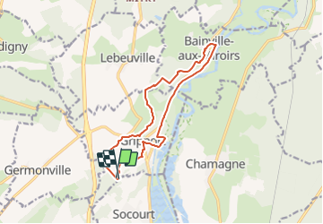
![](/images/other/stat-length.png)
![Tour Zu Fuß Gripport - Circuit de Viacelle - Photo](https://media.geolcdn.com/t/1900/400/f4362cdc-4ce2-4be1-80fb-708f5c17064d.jpeg&format=pjpeg&maxdim=2)
Circuit de Viacelle
SityTrail - itinéraires balisés pédestres
Tous les sentiers balisés d’Europe GUIDE+
![Länge](/images/other/stat-length.png)
Länge
12,6 km
![Maximale Höhe](https://static1.geolcdn.com/siteimages/upload/files/1508320355ic_sort_altitude_max_24dp.png)
Maximale Höhe
368 m
![Positive Höhendifferenz](https://static1.geolcdn.com/siteimages/upload/files/1508320355ic_sort_den_pos_24dp.png)
Positive Höhendifferenz
251 m
![Km-Effort](/images/other/stat-length.png)
Km-Effort
15,9 km
![Min. Höhe](https://static1.geolcdn.com/siteimages/upload/files/1508320355ic_sort_altitude_min_24dp.png)
Min. Höhe
251 m
![Negative Höhendifferenz](https://static1.geolcdn.com/siteimages/upload/files/1508320355ic_sort_den_neg_24dp.png)
Negative Höhendifferenz
252 m
![Boucle](https://static1.geolcdn.com/siteimages/upload/files/16400158638029165_repeat_loop_refresh_sync_direction_icon.png)
Boucle
Ja
Kennzeichnung
Erstellungsdatum :
2022-02-15 18:28:49.344
Letzte Änderung :
2022-03-02 21:03:56.792
![Zu Fuß](https://static1.geolcdn.com/sitytour/trail-icons/100.png)
3h36
Schwierigkeit : Einfach
![Scannen Sie diesen QR-Code, um die Tour in der SityTrail-Anwendung zu öffnen](https://capi.geolives.com/qq0zvz2zws4bq2lad0pu/sitytour/trails/3123645/qr.png?size=200)
Kostenlosegpshiking-Anwendung
Über SityTrail
Tour Zu Fuß von 12,6 km verfügbar auf Großer Osten, Mörthe und Mosel, Gripport. Diese Tour wird von SityTrail - itinéraires balisés pédestres vorgeschlagen.
Beschreibung
Trail created by Les Randonneurs du Saintois.
Website: http://rando.meurthe-et-moselle.fr/carte_toul.html
Ort
Land:
France
Region :
Großer Osten
Abteilung/Provinz :
Mörthe und Mosel
Kommune :
Gripport
Standort:
Unknown
Gehen Sie:(Dec)
Gehen Sie:(UTM)
295943 ; 5365049 (32U) N.
Kommentare
Touren in der Umgebung
![Tour Wandern Charmes - Charmes - Photo](https://media.geolcdn.com/t/375/260/09938933-c74a-4562-9c7f-a692c50ccf43.jpg&format=jpg&maxdim=2)
![Wandern Wandern](https://static1.geolcdn.com/sitytour/trail-icons/101.png)
![Tour Zu Fuß Xirocourt - Circuit des Sources Chaudes - Photo](https://media.geolcdn.com/t/375/260/2a453cc5-5e7d-43d7-a113-3e00a1d7e2bc.jpeg&format=jpg&maxdim=2)
![Zu Fuß Zu Fuß](https://static1.geolcdn.com/sitytour/trail-icons/100.png)
Circuit des Sources Chaudes
Zu Fuß
Einfach
Xirocourt,
Großer Osten,
Mörthe und Mosel,
France
![](/images/other/stat-length.png)
8,1 km | 9,9 km-effort
2h 14min
![](https://static1.geolcdn.com/siteimages/upload/files/16400158638029165_repeat_loop_refresh_sync_direction_icon.png)
Ja
![Tour Zu Fuß Avrainville - Circuit entre Vignes et Clochers - Photo](https://media.geolcdn.com/t/375/260/cc23d455-7371-45be-8e05-64f54f0f742a.jpeg&format=jpg&maxdim=2)
![Zu Fuß Zu Fuß](https://static1.geolcdn.com/sitytour/trail-icons/100.png)
Circuit entre Vignes et Clochers
Zu Fuß
Einfach
Avrainville,
Großer Osten,
Vogesen,
France
![](/images/other/stat-length.png)
16,1 km | 19,4 km-effort
4h 24min
![](https://static1.geolcdn.com/siteimages/upload/files/16400158638029165_repeat_loop_refresh_sync_direction_icon.png)
Ja
![Tour Wandern Charmes - Charmes Île sous Essegney - Photo](https://media.geolcdn.com/t/375/260/8e8d0c8f-c1af-413e-962a-acb8a804c5c8.jpg&format=jpg&maxdim=2)
![Wandern Wandern](https://static1.geolcdn.com/sitytour/trail-icons/101.png)
Charmes Île sous Essegney
Wandern
Charmes,
Großer Osten,
Vogesen,
France
![](/images/other/stat-length.png)
5,3 km | 5,9 km-effort
1h 45min
![](https://static1.geolcdn.com/siteimages/upload/files/16400158638029165_repeat_loop_refresh_sync_direction_icon.png)
Ja
![Tour Wandern Charmes - charmes - Photo](https://media.geolcdn.com/t/375/260/ec135420-ff52-45f8-a92d-19b9f128f4e7.jpg&format=jpg&maxdim=2)
![Wandern Wandern](https://static1.geolcdn.com/sitytour/trail-icons/101.png)
charmes
Wandern
Sehr leicht
Charmes,
Großer Osten,
Vogesen,
France
![](/images/other/stat-length.png)
5,7 km | 6,2 km-effort
2h 5min
![](https://static1.geolcdn.com/siteimages/upload/files/16400158638029165_repeat_loop_refresh_sync_direction_icon.png)
Ja
![Tour Wandern Charmes - tranchée loup - Photo](https://media.geolcdn.com/t/375/260/ext.jpg?maxdim=2&url=https%3A%2F%2Fstatic1.geolcdn.com%2Fsiteimages%2Fupload%2Ffiles%2F1553511878bg_sport_marche.png)
![Wandern Wandern](https://static1.geolcdn.com/sitytour/trail-icons/101.png)
tranchée loup
Wandern
Einfach
(1)
Charmes,
Großer Osten,
Vogesen,
France
![](/images/other/stat-length.png)
11 km | 12,4 km-effort
2h 44min
![](https://static1.geolcdn.com/siteimages/upload/files/16400158638029165_repeat_loop_refresh_sync_direction_icon.png)
Ja
![Tour Andere Aktivitäten Charmes - joelette - Photo](https://media.geolcdn.com/t/375/260/ext.jpg?maxdim=2&url=https%3A%2F%2Fservices.sitytrail.com%2FGeolivesWS%2FDownloadMedia.ashx%3FTrailID%3D159139%26Media%3D20121021130847.jpeg)
![Andere Aktivitäten Andere Aktivitäten](https://static1.geolcdn.com/sitytour/trail-icons/900.png)
joelette
Andere Aktivitäten
Sehr leicht
Charmes,
Großer Osten,
Vogesen,
France
![](/images/other/stat-length.png)
12 km | 15,1 km-effort
3h 8min
![](https://static1.geolcdn.com/siteimages/upload/files/16400158638029165_repeat_loop_refresh_sync_direction_icon.png)
Nein
![Tour Rennrad Charmes - Charmes le 29 07 2023 - Photo](https://media.geolcdn.com/t/375/260/63fde4c8-6cf7-4005-acb4-0f5d2c73424a.jpg&format=jpg&maxdim=2)
![Rennrad Rennrad](https://static1.geolcdn.com/sitytour/trail-icons/201.png)
Charmes le 29 07 2023
Rennrad
Charmes,
Großer Osten,
Vogesen,
France
![](/images/other/stat-length.png)
25 km | 27 km-effort
1h 48min
![](https://static1.geolcdn.com/siteimages/upload/files/16400158638029165_repeat_loop_refresh_sync_direction_icon.png)
Ja
![Tour Zu Fuß Florémont - Variante Bois Banni - Photo](https://media.geolcdn.com/t/375/260/ext.jpg?maxdim=2&url=https%3A%2F%2Fstatic1.geolcdn.com%2Fsiteimages%2Fupload%2Ffiles%2F1545311037marcheuse_200dpi.jpg)
![Zu Fuß Zu Fuß](https://static1.geolcdn.com/sitytour/trail-icons/100.png)
Variante Bois Banni
Zu Fuß
Einfach
Florémont,
Großer Osten,
Vogesen,
France
![](/images/other/stat-length.png)
3,5 km | 4,6 km-effort
1h 2min
![](https://static1.geolcdn.com/siteimages/upload/files/16400158638029165_repeat_loop_refresh_sync_direction_icon.png)
Nein