![](/images/other/stat-length.png)
![Tour Wandern Vendoire - Boucle de Vendoire - Photo](https://media.geolcdn.com/t/1900/400/ext.pjpeg?maxdim=2&url=https%3A%2F%2Fstatic1.geolcdn.com%2Fsiteimages%2Fupload%2Ffiles%2F1553511878bg_sport_marche.png)
Boucle de Vendoire
swp648
Benutzer
![Länge](/images/other/stat-length.png)
Länge
7,2 km
![Maximale Höhe](https://static1.geolcdn.com/siteimages/upload/files/1508320355ic_sort_altitude_max_24dp.png)
Maximale Höhe
153 m
![Positive Höhendifferenz](https://static1.geolcdn.com/siteimages/upload/files/1508320355ic_sort_den_pos_24dp.png)
Positive Höhendifferenz
115 m
![Km-Effort](/images/other/stat-length.png)
Km-Effort
8,7 km
![Min. Höhe](https://static1.geolcdn.com/siteimages/upload/files/1508320355ic_sort_altitude_min_24dp.png)
Min. Höhe
72 m
![Negative Höhendifferenz](https://static1.geolcdn.com/siteimages/upload/files/1508320355ic_sort_den_neg_24dp.png)
Negative Höhendifferenz
115 m
![Boucle](https://static1.geolcdn.com/siteimages/upload/files/16400158638029165_repeat_loop_refresh_sync_direction_icon.png)
Boucle
Ja
Erstellungsdatum :
2022-02-15 17:41:05.814
Letzte Änderung :
2022-02-15 17:45:36.734
![Wandern](https://static1.geolcdn.com/sitytour/trail-icons/101.png)
1h59
Schwierigkeit : Medium
![Scannen Sie diesen QR-Code, um die Tour in der SityTrail-Anwendung zu öffnen](https://capi.geolives.com/qq0zvz2zws4bq2lad0pu/sitytour/trails/3122812/qr.png?size=200)
Kostenlosegpshiking-Anwendung
Über SityTrail
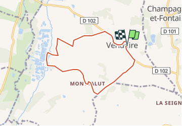
Tour Wandern von 7,2 km verfügbar auf Neu-Aquitanien, Dordogne, Vendoire. Diese Tour wird von swp648 vorgeschlagen.
Beschreibung
Départ de Vendoire
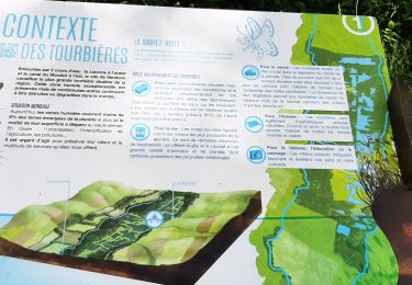
Jolie balade bucolique , admirez l'église et le château de Vendoire, puis à mi-parcours découvrez le secret des tourbières et ses espèces protégées.
Ort
Land:
France
Region :
Neu-Aquitanien
Abteilung/Provinz :
Dordogne
Kommune :
Vendoire
Standort:
Unknown
Gehen Sie:(Dec)
Gehen Sie:(UTM)
289013 ; 5032536 (31T) N.
Kommentare
Touren in der Umgebung
![Tour Wandern Gurat - Entre Gurat 16 et Les tourbières de Vendoire 24 - Photo](https://media.geolcdn.com/t/375/260/f5f377f4-a21b-4305-9b5e-a3f726169c3b.jpg&format=jpg&maxdim=2)
![Wandern Wandern](https://static1.geolcdn.com/sitytour/trail-icons/101.png)
Entre Gurat 16 et Les tourbières de Vendoire 24
Wandern
Einfach
Gurat,
Neu-Aquitanien,
Charente,
France
![](/images/other/stat-length.png)
4,9 km | 5,3 km-effort
1h 9min
![](https://static1.geolcdn.com/siteimages/upload/files/16400158638029165_repeat_loop_refresh_sync_direction_icon.png)
Ja
![Tour Wandern La Chapelle-Grésignac - La Chapelle - gresignac - Photo](https://media.geolcdn.com/t/375/260/ext.jpg?maxdim=2&url=https%3A%2F%2Fservices.sitytrail.com%2FGeolivesWS%2FDownloadMedia.ashx%3FTrailID%3D1088307%26Media%3D20181220114936.jpg)
![Wandern Wandern](https://static1.geolcdn.com/sitytour/trail-icons/101.png)
La Chapelle - gresignac
Wandern
Sehr leicht
La Chapelle-Grésignac,
Neu-Aquitanien,
Dordogne,
France
![](/images/other/stat-length.png)
8,5 km | 10,1 km-effort
2h 11min
![](https://static1.geolcdn.com/siteimages/upload/files/16400158638029165_repeat_loop_refresh_sync_direction_icon.png)
Ja
![Tour Wandern Gurat - Gurat ( rouge ) - Photo](https://media.geolcdn.com/t/375/260/ext.jpg?maxdim=2&url=https%3A%2F%2Fstatic1.geolcdn.com%2Fsiteimages%2Fupload%2Ffiles%2F1553511878bg_sport_marche.png)
![Wandern Wandern](https://static1.geolcdn.com/sitytour/trail-icons/101.png)
Gurat ( rouge )
Wandern
Schwierig
Gurat,
Neu-Aquitanien,
Charente,
France
![](/images/other/stat-length.png)
9,6 km | 12,5 km-effort
2h 57min
![](https://static1.geolcdn.com/siteimages/upload/files/16400158638029165_repeat_loop_refresh_sync_direction_icon.png)
Ja
![Tour Wandern Gurat - gurat - Photo](https://media.geolcdn.com/t/375/260/ext.jpg?maxdim=2&url=https%3A%2F%2Fstatic1.geolcdn.com%2Fsiteimages%2Fupload%2Ffiles%2F1553511878bg_sport_marche.png)
![Wandern Wandern](https://static1.geolcdn.com/sitytour/trail-icons/101.png)