


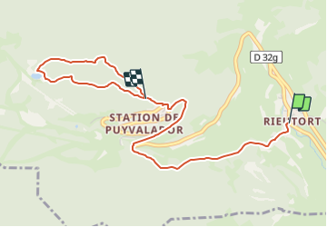

13,1 km | 26 km-effort


Tous les sentiers balisés d’Europe GUIDE+


Kostenlosegpshiking-Anwendung
 SityTrail
IGN / Geografische Institute
SityTrail World
Die Welt öffnet sich für Sie
Tour Zu Fuß von 4,5 km verfügbar auf Okzitanien, Ostpyrenäen, Puyvalador. Diese Tour wird von SityTrail - itinéraires balisés pédestres vorgeschlagen.
Trail created by Communauté de Communes Pyrénées Catalanes.
Symbol: yellow bar

Schneeschuhwandern

Wandern
Wandern


sport

Wandern

Wandern

Wandern

Schneeschuhwandern
Wandern