![](/images/other/stat-length.png)
![Tour Zu Fuß Desenzano del Garda - Barcuzzi – Maguzzano – Desenzano del Garda - Photo](https://media.geolcdn.com/t/1900/400/f8a557b8-7252-4eae-aba5-fed46c8f74dd.jpeg&format=pjpeg&maxdim=2)
Barcuzzi – Maguzzano – Desenzano del Garda
SityTrail - itinéraires balisés pédestres
Tous les sentiers balisés d’Europe GUIDE+
![Länge](/images/other/stat-length.png)
Länge
8,2 km
![Maximale Höhe](https://static1.geolcdn.com/siteimages/upload/files/1508320355ic_sort_altitude_max_24dp.png)
Maximale Höhe
195 m
![Positive Höhendifferenz](https://static1.geolcdn.com/siteimages/upload/files/1508320355ic_sort_den_pos_24dp.png)
Positive Höhendifferenz
197 m
![Km-Effort](/images/other/stat-length.png)
Km-Effort
10,4 km
![Min. Höhe](https://static1.geolcdn.com/siteimages/upload/files/1508320355ic_sort_altitude_min_24dp.png)
Min. Höhe
72 m
![Negative Höhendifferenz](https://static1.geolcdn.com/siteimages/upload/files/1508320355ic_sort_den_neg_24dp.png)
Negative Höhendifferenz
81 m
![Boucle](https://static1.geolcdn.com/siteimages/upload/files/16400158638029165_repeat_loop_refresh_sync_direction_icon.png)
Boucle
Nein
Kennzeichnung
Erstellungsdatum :
2022-02-15 14:24:41.453
Letzte Änderung :
2022-03-01 14:15:21.396
![Zu Fuß](https://static1.geolcdn.com/sitytour/trail-icons/100.png)
2h21
Schwierigkeit : Einfach
![Scannen Sie diesen QR-Code, um die Tour in der SityTrail-Anwendung zu öffnen](https://capi.geolives.com/qq0zvz2zws4bq2lad0pu/sitytour/trails/3119844/qr.png?size=200)
Kostenlosegpshiking-Anwendung
Über SityTrail
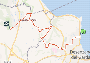
Tour Zu Fuß von 8,2 km verfügbar auf Lombardei, Brescia, Desenzano del Garda. Diese Tour wird von SityTrail - itinéraires balisés pédestres vorgeschlagen.
Beschreibung
Trail created by Club Alpino Italiano - Sezione di Desenzano del Garda.
Website: http://www.cai-desenzano.it/joomla/index.php?option=com_content&view=article&id=29&Itemid=96&lang=it
Ort
Land:
Italy
Region :
Lombardei
Abteilung/Provinz :
Brescia
Kommune :
Desenzano del Garda
Standort:
Unknown
Gehen Sie:(Dec)
Gehen Sie:(UTM)
620223 ; 5037177 (32T) N.
Kommentare
Touren in der Umgebung
![Tour Zu Fuß Lonato del Garda - Drugolo – Padenghe Lido - Photo](https://media.geolcdn.com/t/375/260/4380db2d-1594-4bb0-b2d1-3f80aae08c67.jpeg&format=jpg&maxdim=2)
![Zu Fuß Zu Fuß](https://static1.geolcdn.com/sitytour/trail-icons/100.png)
Drugolo – Padenghe Lido
Zu Fuß
Einfach
Lonato del Garda,
Lombardei,
Brescia,
Italy
![](/images/other/stat-length.png)
5,2 km | 6,6 km-effort
1h 30min
![](https://static1.geolcdn.com/siteimages/upload/files/16400158638029165_repeat_loop_refresh_sync_direction_icon.png)
Nein
![Tour Fahrrad Desenzano del Garda - Venetië dag 24 - Photo](https://media.geolcdn.com/t/375/260/ext.jpg?maxdim=2&url=https%3A%2F%2Fservices.sitytrail.com%2FGeolivesWS%2FDownloadMedia.ashx%3FTrailID%3D776906%26Media%3Dfix__20170621142453.jpg)
![Fahrrad Fahrrad](https://static1.geolcdn.com/sitytour/trail-icons/200.png)
Venetië dag 24
Fahrrad
Einfach
Desenzano del Garda,
Lombardei,
Brescia,
Italy
![](/images/other/stat-length.png)
33 km | 37 km-effort
2h 17min
![](https://static1.geolcdn.com/siteimages/upload/files/16400158638029165_repeat_loop_refresh_sync_direction_icon.png)
Nein