![](/images/other/stat-length.png)
![Tour Zu Fuß Casciago - Sentiero 21 - Photo](https://media.geolcdn.com/t/1900/400/e7bd35b1-5129-4683-95e7-9cc5063e6f6d.jpeg&format=pjpeg&maxdim=2)
Sentiero 21
SityTrail - itinéraires balisés pédestres
Tous les sentiers balisés d’Europe GUIDE+
![Länge](/images/other/stat-length.png)
Länge
9,8 km
![Maximale Höhe](https://static1.geolcdn.com/siteimages/upload/files/1508320355ic_sort_altitude_max_24dp.png)
Maximale Höhe
504 m
![Positive Höhendifferenz](https://static1.geolcdn.com/siteimages/upload/files/1508320355ic_sort_den_pos_24dp.png)
Positive Höhendifferenz
275 m
![Km-Effort](/images/other/stat-length.png)
Km-Effort
13,1 km
![Min. Höhe](https://static1.geolcdn.com/siteimages/upload/files/1508320355ic_sort_altitude_min_24dp.png)
Min. Höhe
295 m
![Negative Höhendifferenz](https://static1.geolcdn.com/siteimages/upload/files/1508320355ic_sort_den_neg_24dp.png)
Negative Höhendifferenz
144 m
![Boucle](https://static1.geolcdn.com/siteimages/upload/files/16400158638029165_repeat_loop_refresh_sync_direction_icon.png)
Boucle
Nein
Kennzeichnung
Erstellungsdatum :
2022-02-15 13:18:31.539
Letzte Änderung :
2022-03-01 11:32:35.825
![Zu Fuß](https://static1.geolcdn.com/sitytour/trail-icons/100.png)
2h57
Schwierigkeit : Einfach
![Scannen Sie diesen QR-Code, um die Tour in der SityTrail-Anwendung zu öffnen](https://capi.geolives.com/qq0zvz2zws4bq2lad0pu/sitytour/trails/3119008/qr.png?size=200)
Kostenlosegpshiking-Anwendung
Über SityTrail
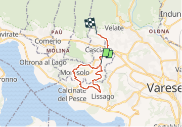
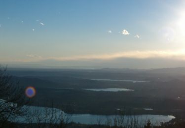
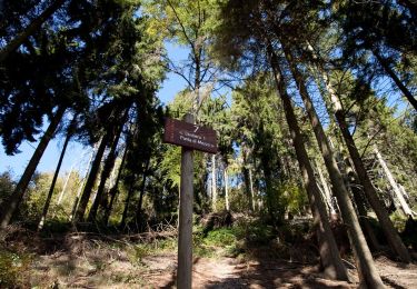
Tour Zu Fuß von 9,8 km verfügbar auf Lombardei, Varese, Casciago. Diese Tour wird von SityTrail - itinéraires balisés pédestres vorgeschlagen.
Beschreibung
Campo dei Fiori 360: Panorami, arte e natura a 360° nel Parco Regionale Campo dei Fiori.
Website: http://www.parcocampodeifiori360.it/
Ort
Land:
Italy
Region :
Lombardei
Abteilung/Provinz :
Varese
Kommune :
Casciago
Standort:
Unknown
Gehen Sie:(Dec)
Gehen Sie:(UTM)
483097 ; 5074998 (32T) N.
Kommentare
Touren in der Umgebung
![Tour Zu Fuß Väris - Via Verde Varesina Tappa 3 - Photo](https://media.geolcdn.com/t/375/260/f7bf4573-73bb-47c7-a9d0-7b51faf56d18.jpeg&format=jpg&maxdim=2)
![Zu Fuß Zu Fuß](https://static1.geolcdn.com/sitytour/trail-icons/100.png)
Via Verde Varesina Tappa 3
Zu Fuß
Medium
Väris,
Lombardei,
Varese,
Italy
![](/images/other/stat-length.png)
14,9 km | 23 km-effort
5h 16min
![](https://static1.geolcdn.com/siteimages/upload/files/16400158638029165_repeat_loop_refresh_sync_direction_icon.png)
Nein
![Tour Zu Fuß Väris - Via Verde Varesina tappa 2 - Photo](https://media.geolcdn.com/t/375/260/e34df6ca-a9ba-41d0-aeaf-7afb84970c00.jpeg&format=jpg&maxdim=2)
![Zu Fuß Zu Fuß](https://static1.geolcdn.com/sitytour/trail-icons/100.png)
Via Verde Varesina tappa 2
Zu Fuß
Einfach
Väris,
Lombardei,
Varese,
Italy
![](/images/other/stat-length.png)
7,8 km | 13,7 km-effort
3h 7min
![](https://static1.geolcdn.com/siteimages/upload/files/16400158638029165_repeat_loop_refresh_sync_direction_icon.png)
Nein
![Tour Zu Fuß Väris - Sentiero 9: Velate - Monte San Francesco - Velate - Photo](https://media.geolcdn.com/t/375/260/cd406513-d539-4b4b-8e7b-b1f452d808cd.jpeg&format=jpg&maxdim=2)
![Zu Fuß Zu Fuß](https://static1.geolcdn.com/sitytour/trail-icons/100.png)
Sentiero 9: Velate - Monte San Francesco - Velate
Zu Fuß
Einfach
Väris,
Lombardei,
Varese,
Italy
![](/images/other/stat-length.png)
3,1 km | 6,7 km-effort
1h 31min
![](https://static1.geolcdn.com/siteimages/upload/files/16400158638029165_repeat_loop_refresh_sync_direction_icon.png)
Nein
![Tour Zu Fuß Väris - Sentiero 7/307: Campo dei Fiori - Punta di Mezzo - Photo](https://media.geolcdn.com/t/375/260/47580b03-b971-4e46-bc27-efa59938cf61.jpeg&format=jpg&maxdim=2)
![Zu Fuß Zu Fuß](https://static1.geolcdn.com/sitytour/trail-icons/100.png)
Sentiero 7/307: Campo dei Fiori - Punta di Mezzo
Zu Fuß
Einfach
Väris,
Lombardei,
Varese,
Italy
![](/images/other/stat-length.png)
3,7 km | 6,2 km-effort
1h 24min
![](https://static1.geolcdn.com/siteimages/upload/files/16400158638029165_repeat_loop_refresh_sync_direction_icon.png)
Nein
![Tour Zu Fuß Väris - Bregazzana - Monte Martica - Photo](https://media.geolcdn.com/t/375/260/e3376ccf-947c-4b7c-8e13-0ea7bd5702cc.jpeg&format=jpg&maxdim=2)
![Zu Fuß Zu Fuß](https://static1.geolcdn.com/sitytour/trail-icons/100.png)
Bregazzana - Monte Martica
Zu Fuß
Einfach
Väris,
Lombardei,
Varese,
Italy
![](/images/other/stat-length.png)
7 km | 12,4 km-effort
2h 49min
![](https://static1.geolcdn.com/siteimages/upload/files/16400158638029165_repeat_loop_refresh_sync_direction_icon.png)
Nein
![Tour Zu Fuß Luvinate - Sentiero Nildo dal Zotto - Photo](https://media.geolcdn.com/t/375/260/4b225d2f-4e5f-4532-8bb6-f718af3feda4.jpeg&format=jpg&maxdim=2)
![Zu Fuß Zu Fuß](https://static1.geolcdn.com/sitytour/trail-icons/100.png)
Sentiero Nildo dal Zotto
Zu Fuß
Einfach
Luvinate,
Lombardei,
Varese,
Italy
![](/images/other/stat-length.png)
4,5 km | 11,9 km-effort
2h 41min
![](https://static1.geolcdn.com/siteimages/upload/files/16400158638029165_repeat_loop_refresh_sync_direction_icon.png)
Nein
![Tour Zu Fuß Comerio - Sentiero 12/312: Comerio - Forte di Orino - Photo](https://media.geolcdn.com/t/375/260/0752d1b2-cab7-49f6-8653-f584bc2a00f9.jpeg&format=jpg&maxdim=2)
![Zu Fuß Zu Fuß](https://static1.geolcdn.com/sitytour/trail-icons/100.png)
Sentiero 12/312: Comerio - Forte di Orino
Zu Fuß
Einfach
Comerio,
Lombardei,
Varese,
Italy
![](/images/other/stat-length.png)
5,4 km | 12,9 km-effort
2h 56min
![](https://static1.geolcdn.com/siteimages/upload/files/16400158638029165_repeat_loop_refresh_sync_direction_icon.png)
Nein
![Tour Zu Fuß Comerio - Sentiero 11/311: Comerio - Forte di Orino - Photo](https://media.geolcdn.com/t/375/260/0752d1b2-cab7-49f6-8653-f584bc2a00f9.jpeg&format=jpg&maxdim=2)
![Zu Fuß Zu Fuß](https://static1.geolcdn.com/sitytour/trail-icons/100.png)
Sentiero 11/311: Comerio - Forte di Orino
Zu Fuß
Einfach
Comerio,
Lombardei,
Varese,
Italy
![](/images/other/stat-length.png)
5,3 km | 12,6 km-effort
2h 52min
![](https://static1.geolcdn.com/siteimages/upload/files/16400158638029165_repeat_loop_refresh_sync_direction_icon.png)
Nein
![Tour Zu Fuß Väris - Sentiero 1/301: Prima Cappella - Forte di Orino - Photo](https://media.geolcdn.com/t/375/260/10bb3b07-8766-4bae-9302-82db2f4e875b.jpeg&format=jpg&maxdim=2)
![Zu Fuß Zu Fuß](https://static1.geolcdn.com/sitytour/trail-icons/100.png)
Sentiero 1/301: Prima Cappella - Forte di Orino
Zu Fuß
Einfach
Väris,
Lombardei,
Varese,
Italy
![](/images/other/stat-length.png)
9,5 km | 16,7 km-effort
3h 47min
![](https://static1.geolcdn.com/siteimages/upload/files/16400158638029165_repeat_loop_refresh_sync_direction_icon.png)
Nein