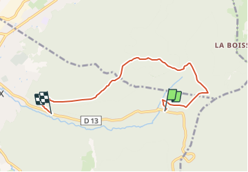
![](/images/other/stat-length.png)
![Tour Zu Fuß Oyonnax - Les Grottes de Lordon - Photo](https://media.geolcdn.com/t/1900/400/ext.pjpeg?maxdim=2&url=https%3A%2F%2Fmedia.geolcdn.com%2Ff%2Fa930d274-da1d-498b-a450-e47786a4355a.jpeg)
Les Grottes de Lordon
SityTrail - itinéraires balisés pédestres
Tous les sentiers balisés d’Europe PRO
![Länge](/images/other/stat-length.png)
Länge
5,9 km
![Maximale Höhe](https://static1.geolcdn.com/siteimages/upload/files/1508320355ic_sort_altitude_max_24dp.png)
Maximale Höhe
1103 m
![Positive Höhendifferenz](https://static1.geolcdn.com/siteimages/upload/files/1508320355ic_sort_den_pos_24dp.png)
Positive Höhendifferenz
328 m
![Km-Effort](/images/other/stat-length.png)
Km-Effort
10,8 km
![Min. Höhe](https://static1.geolcdn.com/siteimages/upload/files/1508320355ic_sort_altitude_min_24dp.png)
Min. Höhe
645 m
![Negative Höhendifferenz](https://static1.geolcdn.com/siteimages/upload/files/1508320355ic_sort_den_neg_24dp.png)
Negative Höhendifferenz
498 m
![Boucle](https://static1.geolcdn.com/siteimages/upload/files/16400158638029165_repeat_loop_refresh_sync_direction_icon.png)
Boucle
Nein
Kennzeichnung
Erstellungsdatum :
2022-02-15 12:06:21.301
Letzte Änderung :
2022-03-02 15:31:16.073
![Zu Fuß](https://static1.geolcdn.com/sitytour/trail-icons/100.png)
2h27
Schwierigkeit : Einfach
![Scannen Sie diesen QR-Code, um die Tour in der SityTrail-Anwendung zu öffnen](https://capi.geolives.com/qq0zvz2zws4bq2lad0pu/sitytour/trails/3118320/qr.png?size=200)
Kostenlosegpshiking-Anwendung
Über SityTrail
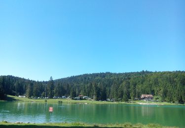
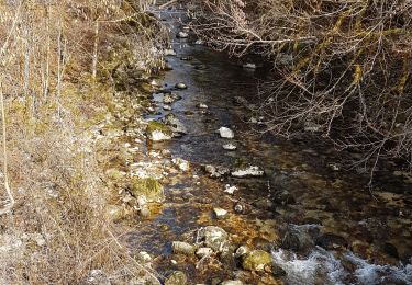
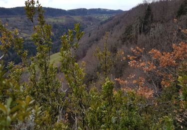
Tour Zu Fuß von 5,9 km verfügbar auf Auvergne-Rhone-Alpen, Ain, Oyonnax. Diese Tour wird von SityTrail - itinéraires balisés pédestres vorgeschlagen.
Beschreibung
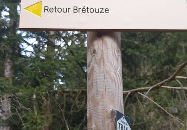
Symbol: Gelber Strich als Wanderzeichen.
Ort
Land:
France
Region :
Auvergne-Rhone-Alpen
Abteilung/Provinz :
Ain
Kommune :
Oyonnax
Standort:
Unknown
Gehen Sie:(Dec)
Gehen Sie:(UTM)
708258 ; 5125850 (31T) N.
Kommentare
Touren in der Umgebung
![Tour Motor Charix - Tour de l'ain moto 2/4 - Photo](https://media.geolcdn.com/t/375/260/ext.jpg?maxdim=2&url=https%3A%2F%2Fstatic1.geolcdn.com%2Fsiteimages%2Fupload%2Ffiles%2F15247431544x4.jpg)
![Motor Motor](https://static1.geolcdn.com/sitytour/trail-icons/400.png)
Tour de l'ain moto 2/4
Motor
Schwierig
(1)
Charix,
Auvergne-Rhone-Alpen,
Ain,
France
![](/images/other/stat-length.png)
93 km | 152 km-effort
Unbekannt
![](https://static1.geolcdn.com/siteimages/upload/files/16400158638029165_repeat_loop_refresh_sync_direction_icon.png)
Nein
![Tour Wandern Échallon - prairie d'échallon belleydoux la borne aux lion des cernoises - Photo](https://media.geolcdn.com/t/375/260/ext.jpg?maxdim=2&url=https%3A%2F%2Fmedia.geolcdn.com%2Ff%2Fda7a05d9-867e-415c-90dc-474e2d70cbe0.jpg)
![Wandern Wandern](https://static1.geolcdn.com/sitytour/trail-icons/101.png)
prairie d'échallon belleydoux la borne aux lion des cernoises
Wandern
Einfach
Échallon,
Auvergne-Rhone-Alpen,
Ain,
France
![](/images/other/stat-length.png)
10,9 km | 14,5 km-effort
3h 2min
![](https://static1.geolcdn.com/siteimages/upload/files/16400158638029165_repeat_loop_refresh_sync_direction_icon.png)
Ja
![Tour Zu Fuß Apremont - Le Lac Genin - Photo](https://media.geolcdn.com/t/375/260/ext.jpg?maxdim=2&url=https%3A%2F%2Fmedia.geolcdn.com%2Ff%2F7213dd61-9d12-4547-a562-5c75c22e1ed8.jpeg)
![Zu Fuß Zu Fuß](https://static1.geolcdn.com/sitytour/trail-icons/100.png)
Le Lac Genin
Zu Fuß
Einfach
Apremont,
Auvergne-Rhone-Alpen,
Ain,
France
![](/images/other/stat-length.png)
9,3 km | 14,6 km-effort
3h 19min
![](https://static1.geolcdn.com/siteimages/upload/files/16400158638029165_repeat_loop_refresh_sync_direction_icon.png)
Ja
![Tour Wandern Charix - lac genin - Photo](https://media.geolcdn.com/t/375/260/ext.jpg?maxdim=2&url=https%3A%2F%2Fmedia.geolcdn.com%2Ff%2F9ddf338e-dc45-4fa8-b522-4c8c87276892.jpg)
![Wandern Wandern](https://static1.geolcdn.com/sitytour/trail-icons/101.png)
lac genin
Wandern
Sehr leicht
Charix,
Auvergne-Rhone-Alpen,
Ain,
France
![](/images/other/stat-length.png)
8,4 km | 11,3 km-effort
23h 34min
![](https://static1.geolcdn.com/siteimages/upload/files/16400158638029165_repeat_loop_refresh_sync_direction_icon.png)
Ja
![Tour Wandern Oyonnax - oyonnax apremont et lac genin - Photo](https://media.geolcdn.com/t/375/260/ext.jpg?maxdim=2&url=https%3A%2F%2Fmedia.geolcdn.com%2Ff%2Fa7db6af2-f685-46f8-bf85-49e70941f57e.jpg)
![Wandern Wandern](https://static1.geolcdn.com/sitytour/trail-icons/101.png)
oyonnax apremont et lac genin
Wandern
Sehr schwierig
Oyonnax,
Auvergne-Rhone-Alpen,
Ain,
France
![](/images/other/stat-length.png)
19,3 km | 28 km-effort
9h 48min
![](https://static1.geolcdn.com/siteimages/upload/files/16400158638029165_repeat_loop_refresh_sync_direction_icon.png)
Nein
![Tour Wandern Arbent - Arbent-Sieges-Rhien - Photo](https://media.geolcdn.com/t/375/260/ext.jpg?maxdim=2&url=https%3A%2F%2Fmedia.geolcdn.com%2Ff%2F2722f756-a745-41ae-a36b-9c332d997715.jpg)
![Wandern Wandern](https://static1.geolcdn.com/sitytour/trail-icons/101.png)
Arbent-Sieges-Rhien
Wandern
Medium
Arbent,
Auvergne-Rhone-Alpen,
Ain,
France
![](/images/other/stat-length.png)
12,3 km | 17,8 km-effort
3h 25min
![](https://static1.geolcdn.com/siteimages/upload/files/16400158638029165_repeat_loop_refresh_sync_direction_icon.png)
Ja
![Tour Wandern Échallon - Echallon: moyenne Semine - Photo](https://media.geolcdn.com/t/375/260/ext.jpg?maxdim=2&url=https%3A%2F%2Fmedia.geolcdn.com%2Ff%2Ffaf68926-9cf8-4b3a-af75-0d8aa555f58d.jpg)
![Wandern Wandern](https://static1.geolcdn.com/sitytour/trail-icons/101.png)
Echallon: moyenne Semine
Wandern
Einfach
Échallon,
Auvergne-Rhone-Alpen,
Ain,
France
![](/images/other/stat-length.png)
10,5 km | 16,2 km-effort
2h 52min
![](https://static1.geolcdn.com/siteimages/upload/files/16400158638029165_repeat_loop_refresh_sync_direction_icon.png)
Ja
![Tour Wandern Bellignat - Nierme: Belvedere du Haut Cret - Photo](https://media.geolcdn.com/t/375/260/ext.jpg?maxdim=2&url=https%3A%2F%2Fmedia.geolcdn.com%2Ff%2F561c1f01-ec4d-4f72-be81-da8937e4f9de.jpg)
![Wandern Wandern](https://static1.geolcdn.com/sitytour/trail-icons/101.png)
Nierme: Belvedere du Haut Cret
Wandern
Medium
Bellignat,
Auvergne-Rhone-Alpen,
Ain,
France
![](/images/other/stat-length.png)
9 km | 14,8 km-effort
3h 24min
![](https://static1.geolcdn.com/siteimages/upload/files/16400158638029165_repeat_loop_refresh_sync_direction_icon.png)
Ja
![Tour Wandern Arbent - Arbent Bois du Roy - Photo](https://media.geolcdn.com/t/375/260/ext.jpg?maxdim=2&url=https%3A%2F%2Fmedia.geolcdn.com%2Ff%2Fe481b381-889c-41ae-927f-5fff1f352a67.jpg)
![Wandern Wandern](https://static1.geolcdn.com/sitytour/trail-icons/101.png)
Arbent Bois du Roy
Wandern
Medium
Arbent,
Auvergne-Rhone-Alpen,
Ain,
France
![](/images/other/stat-length.png)
13 km | 18,9 km-effort
3h 40min
![](https://static1.geolcdn.com/siteimages/upload/files/16400158638029165_repeat_loop_refresh_sync_direction_icon.png)
Ja