![](/images/other/stat-length.png)
![Tour Zu Fuß Fénis - Veulla - Colle Medzove - Photo](https://media.geolcdn.com/t/1900/400/0fe8d71b-c839-4ccc-a2c2-a4c9589efaf9.jpeg&format=pjpeg&maxdim=2)
Veulla - Colle Medzove
SityTrail - itinéraires balisés pédestres
Tous les sentiers balisés d’Europe GUIDE+
![Länge](/images/other/stat-length.png)
Länge
12,5 km
![Maximale Höhe](https://static1.geolcdn.com/siteimages/upload/files/1508320355ic_sort_altitude_max_24dp.png)
Maximale Höhe
2616 m
![Positive Höhendifferenz](https://static1.geolcdn.com/siteimages/upload/files/1508320355ic_sort_den_pos_24dp.png)
Positive Höhendifferenz
69 m
![Km-Effort](/images/other/stat-length.png)
Km-Effort
17,8 km
![Min. Höhe](https://static1.geolcdn.com/siteimages/upload/files/1508320355ic_sort_altitude_min_24dp.png)
Min. Höhe
1292 m
![Negative Höhendifferenz](https://static1.geolcdn.com/siteimages/upload/files/1508320355ic_sort_den_neg_24dp.png)
Negative Höhendifferenz
1390 m
![Boucle](https://static1.geolcdn.com/siteimages/upload/files/16400158638029165_repeat_loop_refresh_sync_direction_icon.png)
Boucle
Nein
Kennzeichnung
Erstellungsdatum :
2022-02-15 09:44:17.525
Letzte Änderung :
2022-03-01 07:13:15.008
![Zu Fuß](https://static1.geolcdn.com/sitytour/trail-icons/100.png)
4h03
Schwierigkeit : Einfach
![Scannen Sie diesen QR-Code, um die Tour in der SityTrail-Anwendung zu öffnen](https://capi.geolives.com/qq0zvz2zws4bq2lad0pu/sitytour/trails/3117413/qr.png?size=200)
Kostenlosegpshiking-Anwendung
Über SityTrail
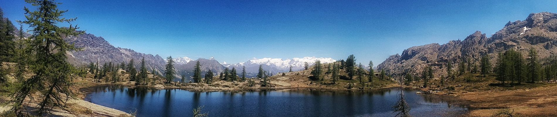
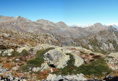
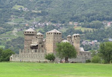
Tour Zu Fuß von 12,5 km verfügbar auf Aostatal, Unbekannt, Fénis. Diese Tour wird von SityTrail - itinéraires balisés pédestres vorgeschlagen.
Beschreibung
Symbol: 5C on yellow dot in black circle, or yellow line
Ort
Land:
Italy
Region :
Aostatal
Abteilung/Provinz :
Unbekannt
Kommune :
Fénis
Standort:
Unknown
Gehen Sie:(Dec)
Gehen Sie:(UTM)
386448 ; 5055181 (32T) N.
Kommentare
Touren in der Umgebung
![Tour Zu Fuß Champorcher - Alta Via n. 2 della Valle d'Aosta - Tappa 12 - Photo](https://media.geolcdn.com/t/375/260/69a2f729-076d-4f56-aeb2-68e9040ba56b.jpeg&format=jpg&maxdim=2)
![Zu Fuß Zu Fuß](https://static1.geolcdn.com/sitytour/trail-icons/100.png)
Alta Via n. 2 della Valle d'Aosta - Tappa 12
Zu Fuß
Einfach
Champorcher,
Aostatal,
Unbekannt,
Italy
![](/images/other/stat-length.png)
8,8 km | 11,9 km-effort
2h 42min
![](https://static1.geolcdn.com/siteimages/upload/files/16400158638029165_repeat_loop_refresh_sync_direction_icon.png)
Nein
![Tour Zu Fuß Fénis - Itinerario 4 Clavalité Col de Mezove - Photo](https://media.geolcdn.com/t/375/260/52df5386-0d6a-4af2-9011-105bc871ff22.jpeg&format=jpg&maxdim=2)
![Zu Fuß Zu Fuß](https://static1.geolcdn.com/sitytour/trail-icons/100.png)
Itinerario 4 Clavalité Col de Mezove
Zu Fuß
Einfach
Fénis,
Aostatal,
Unbekannt,
Italy
![](/images/other/stat-length.png)
4,8 km | 7,4 km-effort
1h 41min
![](https://static1.geolcdn.com/siteimages/upload/files/16400158638029165_repeat_loop_refresh_sync_direction_icon.png)
Nein
![Tour Zu Fuß Cogne - Alta Via n. 2 della Valle d'Aosta - Tappa 11 - Photo](https://media.geolcdn.com/t/375/260/ext.jpg?maxdim=2&url=https%3A%2F%2Fstatic1.geolcdn.com%2Fsiteimages%2Fupload%2Ffiles%2F1545311037marcheuse_200dpi.jpg)
![Zu Fuß Zu Fuß](https://static1.geolcdn.com/sitytour/trail-icons/100.png)
Alta Via n. 2 della Valle d'Aosta - Tappa 11
Zu Fuß
Einfach
Cogne,
Aostatal,
Unbekannt,
Italy
![](/images/other/stat-length.png)
7,5 km | 12,5 km-effort
2h 50min
![](https://static1.geolcdn.com/siteimages/upload/files/16400158638029165_repeat_loop_refresh_sync_direction_icon.png)
Nein
![Tour Zu Fuß Champorcher - Sentiero 5C - Cuneu-Col Fussy - Photo](https://media.geolcdn.com/t/375/260/e59eec27-d654-4d69-986e-2d8d0facddd9.jpeg&format=jpg&maxdim=2)
![Zu Fuß Zu Fuß](https://static1.geolcdn.com/sitytour/trail-icons/100.png)
Sentiero 5C - Cuneu-Col Fussy
Zu Fuß
Einfach
Champorcher,
Aostatal,
Unbekannt,
Italy
![](/images/other/stat-length.png)
3,2 km | 5,7 km-effort
1h 18min
![](https://static1.geolcdn.com/siteimages/upload/files/16400158638029165_repeat_loop_refresh_sync_direction_icon.png)
Nein
![Tour Zu Fuß Champdepraz - Sentiero Ru de Chevrère et Montjovet - Photo](https://media.geolcdn.com/t/375/260/ext.jpg?maxdim=2&url=https%3A%2F%2Fstatic1.geolcdn.com%2Fsiteimages%2Fupload%2Ffiles%2F1545311037marcheuse_200dpi.jpg)
![Zu Fuß Zu Fuß](https://static1.geolcdn.com/sitytour/trail-icons/100.png)
Sentiero Ru de Chevrère et Montjovet
Zu Fuß
Einfach
(1)
Champdepraz,
Aostatal,
Unbekannt,
Italy
![](/images/other/stat-length.png)
5,6 km | 7,3 km-effort
1h 40min
![](https://static1.geolcdn.com/siteimages/upload/files/16400158638029165_repeat_loop_refresh_sync_direction_icon.png)
Nein
![Tour Zu Fuß Fénis - Sentiero 6 - GrandAlpe-Col Fenis - Photo](https://media.geolcdn.com/t/375/260/ext.jpg?maxdim=2&url=https%3A%2F%2Fstatic1.geolcdn.com%2Fsiteimages%2Fupload%2Ffiles%2F1545311037marcheuse_200dpi.jpg)
![Zu Fuß Zu Fuß](https://static1.geolcdn.com/sitytour/trail-icons/100.png)
Sentiero 6 - GrandAlpe-Col Fenis
Zu Fuß
Einfach
Fénis,
Aostatal,
Unbekannt,
Italy
![](/images/other/stat-length.png)
3,5 km | 10,6 km-effort
2h 24min
![](https://static1.geolcdn.com/siteimages/upload/files/16400158638029165_repeat_loop_refresh_sync_direction_icon.png)
Nein
![Tour Zu Fuß Fénis - Sentiero 5 - Etzely-Col de LìEtzely - Photo](https://media.geolcdn.com/t/375/260/ext.jpg?maxdim=2&url=https%3A%2F%2Fstatic1.geolcdn.com%2Fsiteimages%2Fupload%2Ffiles%2F1545311037marcheuse_200dpi.jpg)
![Zu Fuß Zu Fuß](https://static1.geolcdn.com/sitytour/trail-icons/100.png)
Sentiero 5 - Etzely-Col de LìEtzely
Zu Fuß
Medium
Fénis,
Aostatal,
Unbekannt,
Italy
![](/images/other/stat-length.png)
9,5 km | 22 km-effort
4h 53min
![](https://static1.geolcdn.com/siteimages/upload/files/16400158638029165_repeat_loop_refresh_sync_direction_icon.png)
Nein
![Tour Zu Fuß Fénis - Sentiero 8 - Maisonasse(1.545)-Chardonney-Praz Premier(2.036) - EE - 3h00' - disl. 865 - Photo](https://media.geolcdn.com/t/375/260/ext.jpg?maxdim=2&url=https%3A%2F%2Fstatic1.geolcdn.com%2Fsiteimages%2Fupload%2Ffiles%2F1545311037marcheuse_200dpi.jpg)
![Zu Fuß Zu Fuß](https://static1.geolcdn.com/sitytour/trail-icons/100.png)
Sentiero 8 - Maisonasse(1.545)-Chardonney-Praz Premier(2.036) - EE - 3h00' - ...
Zu Fuß
Einfach
Fénis,
Aostatal,
Unbekannt,
Italy
![](/images/other/stat-length.png)
4,8 km | 13,4 km-effort
3h 2min
![](https://static1.geolcdn.com/siteimages/upload/files/16400158638029165_repeat_loop_refresh_sync_direction_icon.png)
Nein
![Tour Wandern Champorcher - Alta via val d’Aoste2 etape8 (Champorcher-Crest) - Photo](https://media.geolcdn.com/t/375/260/ext.jpg?maxdim=2&url=https%3A%2F%2Fstatic1.geolcdn.com%2Fsiteimages%2Fupload%2Ffiles%2F1553511878bg_sport_marche.png)
![Wandern Wandern](https://static1.geolcdn.com/sitytour/trail-icons/101.png)
Alta via val d’Aoste2 etape8 (Champorcher-Crest)
Wandern
Sehr schwierig
Champorcher,
Aostatal,
Unbekannt,
Italy
![](/images/other/stat-length.png)
18,7 km | 39 km-effort
6h 9min
![](https://static1.geolcdn.com/siteimages/upload/files/16400158638029165_repeat_loop_refresh_sync_direction_icon.png)
Nein