![](/images/other/stat-length.png)
![Tour Zu Fuß Vialfrè - Sentiero dei massi erratici - Photo](https://media.geolcdn.com/t/1900/400/ext.pjpeg?maxdim=2&url=https%3A%2F%2Fmedia.geolcdn.com%2Ff%2Fe0da5e0e-7d06-433f-bc29-5bd71ec1ac14.jpeg)
Sentiero dei massi erratici
SityTrail - itinéraires balisés pédestres
Tous les sentiers balisés d’Europe PRO
![Länge](/images/other/stat-length.png)
Länge
7,2 km
![Maximale Höhe](https://static1.geolcdn.com/siteimages/upload/files/1508320355ic_sort_altitude_max_24dp.png)
Maximale Höhe
485 m
![Positive Höhendifferenz](https://static1.geolcdn.com/siteimages/upload/files/1508320355ic_sort_den_pos_24dp.png)
Positive Höhendifferenz
125 m
![Km-Effort](/images/other/stat-length.png)
Km-Effort
8,8 km
![Min. Höhe](https://static1.geolcdn.com/siteimages/upload/files/1508320355ic_sort_altitude_min_24dp.png)
Min. Höhe
403 m
![Negative Höhendifferenz](https://static1.geolcdn.com/siteimages/upload/files/1508320355ic_sort_den_neg_24dp.png)
Negative Höhendifferenz
132 m
![Boucle](https://static1.geolcdn.com/siteimages/upload/files/16400158638029165_repeat_loop_refresh_sync_direction_icon.png)
Boucle
Ja
Kennzeichnung
Erstellungsdatum :
2022-02-15 06:08:48.076
Letzte Änderung :
2022-03-01 04:37:31.986
![Zu Fuß](https://static1.geolcdn.com/sitytour/trail-icons/100.png)
2h00
Schwierigkeit : Einfach
![Scannen Sie diesen QR-Code, um die Tour in der SityTrail-Anwendung zu öffnen](https://capi.geolives.com/qq0zvz2zws4bq2lad0pu/sitytour/trails/3116328/qr.png?size=200)
Kostenlosegpshiking-Anwendung
Über SityTrail
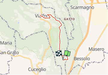
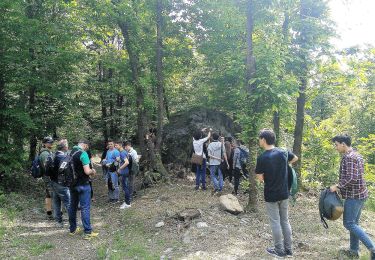
Tour Zu Fuß von 7,2 km verfügbar auf Piemont, Torino, Vialfrè. Diese Tour wird von SityTrail - itinéraires balisés pédestres vorgeschlagen.
Beschreibung
Trail created by Proloco di Vialfrè.
Website: http://collinecanavesane.it/percorso/sentiero-dei-massi-erratici/
Ort
Land:
Italy
Region :
Piemont
Abteilung/Provinz :
Torino
Kommune :
Vialfrè
Standort:
Unknown
Gehen Sie:(Dec)
Gehen Sie:(UTM)
408378 ; 5023961 (32T) N.
Kommentare
Touren in der Umgebung
![Tour Zu Fuß San Giorgio Canavese - ETOP1320000 - Photo](https://media.geolcdn.com/t/375/260/ext.jpg?maxdim=2&url=https%3A%2F%2Fmedia.geolcdn.com%2Ff%2Ffb035e0f-1086-4f18-ba97-e1d3bed2eb0f.jpeg)
![Zu Fuß Zu Fuß](https://static1.geolcdn.com/sitytour/trail-icons/100.png)
ETOP1320000
Zu Fuß
Einfach
San Giorgio Canavese,
Piemont,
Torino,
Italy
![](/images/other/stat-length.png)
13,7 km | 15,3 km-effort
3h 28min
![](https://static1.geolcdn.com/siteimages/upload/files/16400158638029165_repeat_loop_refresh_sync_direction_icon.png)
Nein
![Tour Zu Fuß Castellamonte - ETOP103000A - Photo](https://media.geolcdn.com/t/375/260/ext.jpg?maxdim=2&url=https%3A%2F%2Fmedia.geolcdn.com%2Ff%2F63015f0a-04a9-4a7e-8c85-e40af8987184.jpeg)
![Zu Fuß Zu Fuß](https://static1.geolcdn.com/sitytour/trail-icons/100.png)
ETOP103000A
Zu Fuß
Einfach
Castellamonte,
Piemont,
Torino,
Italy
![](/images/other/stat-length.png)
9,1 km | 12,7 km-effort
2h 53min
![](https://static1.geolcdn.com/siteimages/upload/files/16400158638029165_repeat_loop_refresh_sync_direction_icon.png)
Nein
![Tour Zu Fuß Candia Canavese - Barone Canavese, bivio104-TOP101 presso Torre-Mercenasco bivio costa Becchera - Photo](https://media.geolcdn.com/t/375/260/ext.jpg?maxdim=2&url=https%3A%2F%2Fmedia.geolcdn.com%2Ff%2F0be3cc00-7486-4f80-ba82-d265ce61dddc.jpeg)
![Zu Fuß Zu Fuß](https://static1.geolcdn.com/sitytour/trail-icons/100.png)
Barone Canavese, bivio104-TOP101 presso Torre-Mercenasco bivio costa Becchera
Zu Fuß
Einfach
Candia Canavese,
Piemont,
Torino,
Italy
![](/images/other/stat-length.png)
7,4 km | 9,1 km-effort
2h 4min
![](https://static1.geolcdn.com/siteimages/upload/files/16400158638029165_repeat_loop_refresh_sync_direction_icon.png)
Nein
![Tour Zu Fuß Vialfrè - Castellamonte fraz. Pricco, bivio TOP100 - Vialfre', bivio TOP100-TOP101 - Photo](https://media.geolcdn.com/t/375/260/ext.jpg?maxdim=2&url=https%3A%2F%2Fmedia.geolcdn.com%2Ff%2F9208ca07-9281-4e8f-abb2-762b7048c1d1.jpeg)
![Zu Fuß Zu Fuß](https://static1.geolcdn.com/sitytour/trail-icons/100.png)
Castellamonte fraz. Pricco, bivio TOP100 - Vialfre', bivio TOP100-TOP101
Zu Fuß
Einfach
Vialfrè,
Piemont,
Torino,
Italy
![](/images/other/stat-length.png)
6,2 km | 7,2 km-effort
1h 38min
![](https://static1.geolcdn.com/siteimages/upload/files/16400158638029165_repeat_loop_refresh_sync_direction_icon.png)
Nein
![Tour Zu Fuß Vialfrè - Strambinello -Vialfrè - Photo](https://media.geolcdn.com/t/375/260/ext.jpg?maxdim=2&url=https%3A%2F%2Fmedia.geolcdn.com%2Ff%2F430909ee-a21e-4ca5-9086-77cc105a86a8.jpeg)
![Zu Fuß Zu Fuß](https://static1.geolcdn.com/sitytour/trail-icons/100.png)
Strambinello -Vialfrè
Zu Fuß
Medium
Vialfrè,
Piemont,
Torino,
Italy
![](/images/other/stat-length.png)
16,5 km | 22 km-effort
4h 55min
![](https://static1.geolcdn.com/siteimages/upload/files/16400158638029165_repeat_loop_refresh_sync_direction_icon.png)
Nein
![Tour Zu Fuß Vialfrè - Candia Canavese, bivio102-Vialfre', bivio103 - Photo](https://media.geolcdn.com/t/375/260/ext.jpg?maxdim=2&url=https%3A%2F%2Fmedia.geolcdn.com%2Ff%2Fac389d80-78e4-4588-9c36-72769b9c2fc4.jpeg)
![Zu Fuß Zu Fuß](https://static1.geolcdn.com/sitytour/trail-icons/100.png)
Candia Canavese, bivio102-Vialfre', bivio103
Zu Fuß
Einfach
Vialfrè,
Piemont,
Torino,
Italy
![](/images/other/stat-length.png)
11,6 km | 14,3 km-effort
3h 14min
![](https://static1.geolcdn.com/siteimages/upload/files/16400158638029165_repeat_loop_refresh_sync_direction_icon.png)
Nein
![Tour Zu Fuß Agliè - Alta Via dell’Anfiteatro Morenico di Ivrea - Itinerario di Collegamento di Agliè - Photo](https://media.geolcdn.com/t/375/260/ext.jpg?maxdim=2&url=https%3A%2F%2Fmedia.geolcdn.com%2Ff%2F0ec7e7cc-74f3-4dcc-b809-34a0f0219c58.jpeg)
![Zu Fuß Zu Fuß](https://static1.geolcdn.com/sitytour/trail-icons/100.png)
Alta Via dell’Anfiteatro Morenico di Ivrea - Itinerario di Collegamento di Agliè
Zu Fuß
Einfach
Agliè,
Piemont,
Torino,
Italy
![](/images/other/stat-length.png)
4,1 km | 5,7 km-effort
1h 17min
![](https://static1.geolcdn.com/siteimages/upload/files/16400158638029165_repeat_loop_refresh_sync_direction_icon.png)
Nein
![Tour Zu Fuß Torre Canavese - Alta Via dell'Anfiteatro Morenico di Ivrea - Photo](https://media.geolcdn.com/t/375/260/ext.jpg?maxdim=2&url=https%3A%2F%2Fmedia.geolcdn.com%2Ff%2Faab52108-3181-4f7d-8729-387e20b6d5a2.jpeg)
![Zu Fuß Zu Fuß](https://static1.geolcdn.com/sitytour/trail-icons/100.png)
Alta Via dell'Anfiteatro Morenico di Ivrea
Zu Fuß
Medium
Torre Canavese,
Piemont,
Torino,
Italy
![](/images/other/stat-length.png)
17,1 km | 22 km-effort
5h 0min
![](https://static1.geolcdn.com/siteimages/upload/files/16400158638029165_repeat_loop_refresh_sync_direction_icon.png)
Nein
![Tour Zu Fuß San Giorgio Canavese - ETOP13300A - Photo](https://media.geolcdn.com/t/375/260/ext.jpg?maxdim=2&url=https%3A%2F%2Fmedia.geolcdn.com%2Ff%2F71605cd3-1216-4ce3-b88c-6af1149dcd7b.jpeg)
![Zu Fuß Zu Fuß](https://static1.geolcdn.com/sitytour/trail-icons/100.png)
ETOP13300A
Zu Fuß
Einfach
San Giorgio Canavese,
Piemont,
Torino,
Italy
![](/images/other/stat-length.png)
6 km | 6,4 km-effort
1h 27min
![](https://static1.geolcdn.com/siteimages/upload/files/16400158638029165_repeat_loop_refresh_sync_direction_icon.png)
Nein