![](/images/other/stat-length.png)
![Tour Zu Fuß Bréxent-Énocq - Sentier de la Terre à Cloque - Photo](https://media.geolcdn.com/t/1900/400/5036ca43-45e3-4ee9-969e-77902398a6db.jpeg&format=pjpeg&maxdim=2)
Sentier de la Terre à Cloque
SityTrail - itinéraires balisés pédestres
Tous les sentiers balisés d’Europe GUIDE+
![Länge](/images/other/stat-length.png)
Länge
11,7 km
![Maximale Höhe](https://static1.geolcdn.com/siteimages/upload/files/1508320355ic_sort_altitude_max_24dp.png)
Maximale Höhe
94 m
![Positive Höhendifferenz](https://static1.geolcdn.com/siteimages/upload/files/1508320355ic_sort_den_pos_24dp.png)
Positive Höhendifferenz
187 m
![Km-Effort](/images/other/stat-length.png)
Km-Effort
14,2 km
![Min. Höhe](https://static1.geolcdn.com/siteimages/upload/files/1508320355ic_sort_altitude_min_24dp.png)
Min. Höhe
9 m
![Negative Höhendifferenz](https://static1.geolcdn.com/siteimages/upload/files/1508320355ic_sort_den_neg_24dp.png)
Negative Höhendifferenz
187 m
![Boucle](https://static1.geolcdn.com/siteimages/upload/files/16400158638029165_repeat_loop_refresh_sync_direction_icon.png)
Boucle
Ja
Kennzeichnung
Erstellungsdatum :
2022-02-15 04:31:54.988
Letzte Änderung :
2022-03-02 12:45:06.901
![Zu Fuß](https://static1.geolcdn.com/sitytour/trail-icons/100.png)
3h14
Schwierigkeit : Einfach
![Scannen Sie diesen QR-Code, um die Tour in der SityTrail-Anwendung zu öffnen](https://capi.geolives.com/qq0zvz2zws4bq2lad0pu/sitytour/trails/3115041/qr.png?size=200)
Kostenlosegpshiking-Anwendung
Über SityTrail
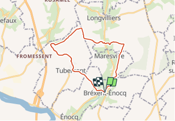
Tour Zu Fuß von 11,7 km verfügbar auf Nordfrankreich, Pas-de-Calais, Bréxent-Énocq. Diese Tour wird von SityTrail - itinéraires balisés pédestres vorgeschlagen.
Beschreibung
By ZeHilkers
Ort
Land:
France
Region :
Nordfrankreich
Abteilung/Provinz :
Pas-de-Calais
Kommune :
Bréxent-Énocq
Standort:
Unknown
Gehen Sie:(Dec)
Gehen Sie:(UTM)
409867 ; 5596069 (31U) N.
Kommentare
Touren in der Umgebung
![Tour Wandern Montreuil - De la Course à la Canche - Photo](https://media.geolcdn.com/t/375/260/ext.jpg?maxdim=2&url=https%3A%2F%2Fservices.sitytrail.com%2FGeolivesWS%2FDownloadMedia.ashx%3FTrailID%3D108132%26Media%3D154_6.jpg)
![Wandern Wandern](https://static1.geolcdn.com/sitytour/trail-icons/101.png)
De la Course à la Canche
Wandern
Schwierig
(1)
Montreuil,
Nordfrankreich,
Pas-de-Calais,
France
![](/images/other/stat-length.png)
25 km | 30 km-effort
6h 0min
![](https://static1.geolcdn.com/siteimages/upload/files/16400158638029165_repeat_loop_refresh_sync_direction_icon.png)
Ja
![Tour Wandern Montreuil - Circuit Montreuil sur Mer - Photo](https://media.geolcdn.com/t/375/260/d84a4202-d638-48ac-a095-c0eef2a63e95.jpg&format=jpg&maxdim=2)
![Wandern Wandern](https://static1.geolcdn.com/sitytour/trail-icons/101.png)
Circuit Montreuil sur Mer
Wandern
Medium
Montreuil,
Nordfrankreich,
Pas-de-Calais,
France
![](/images/other/stat-length.png)
7,6 km | 8,8 km-effort
1h 55min
![](https://static1.geolcdn.com/siteimages/upload/files/16400158638029165_repeat_loop_refresh_sync_direction_icon.png)
Ja
![Tour Wandern Saint-Josse - Sentier des Briqueteries - Saint Josse - Photo](https://media.geolcdn.com/t/375/260/ext.jpg?maxdim=2&url=https%3A%2F%2Fservices.sitytrail.com%2FGeolivesWS%2FDownloadMedia.ashx%3FTrailID%3D465741%26Media%3D6b303fc8-d5e9-41fa-9b96-d8c29ab481f7.jpg)
![Wandern Wandern](https://static1.geolcdn.com/sitytour/trail-icons/101.png)
Sentier des Briqueteries - Saint Josse
Wandern
Einfach
(1)
Saint-Josse,
Nordfrankreich,
Pas-de-Calais,
France
![](/images/other/stat-length.png)
7,4 km | 8,7 km-effort
2h 0min
![](https://static1.geolcdn.com/siteimages/upload/files/16400158638029165_repeat_loop_refresh_sync_direction_icon.png)
Ja
![Tour Mountainbike Longvilliers - Le bois de Longvilliers - Photo](https://media.geolcdn.com/t/375/260/ext.jpg?maxdim=2&url=https%3A%2F%2Fservices.sitytrail.com%2FGeolivesWS%2FDownloadMedia.ashx%3FTrailID%3D110036%26Media%3D5138_5.jpg)
![Mountainbike Mountainbike](https://static1.geolcdn.com/sitytour/trail-icons/202.png)
Le bois de Longvilliers
Mountainbike
Medium
Longvilliers,
Nordfrankreich,
Pas-de-Calais,
France
![](/images/other/stat-length.png)
11,2 km | 13,5 km-effort
1h 19min
![](https://static1.geolcdn.com/siteimages/upload/files/16400158638029165_repeat_loop_refresh_sync_direction_icon.png)
Ja
![Tour Wandern Longvilliers - Le bois de Longvilliers - Photo](https://media.geolcdn.com/t/375/260/ext.jpg?maxdim=2&url=https%3A%2F%2Fservices.sitytrail.com%2FGeolivesWS%2FDownloadMedia.ashx%3FTrailID%3D110035%26Media%3D5138_5.jpg)
![Wandern Wandern](https://static1.geolcdn.com/sitytour/trail-icons/101.png)
Le bois de Longvilliers
Wandern
Medium
Longvilliers,
Nordfrankreich,
Pas-de-Calais,
France
![](/images/other/stat-length.png)
11,2 km | 13,5 km-effort
2h 49min
![](https://static1.geolcdn.com/siteimages/upload/files/16400158638029165_repeat_loop_refresh_sync_direction_icon.png)
Ja
![Tour Mountainbike Tubersent - Les Hauts de Tubersent - Photo](https://media.geolcdn.com/t/375/260/ext.jpg?maxdim=2&url=https%3A%2F%2Fservices.sitytrail.com%2FGeolivesWS%2FDownloadMedia.ashx%3FTrailID%3D110032%26Media%3D5136_5.jpg)
![Mountainbike Mountainbike](https://static1.geolcdn.com/sitytour/trail-icons/202.png)
Les Hauts de Tubersent
Mountainbike
Einfach
Tubersent,
Nordfrankreich,
Pas-de-Calais,
France
![](/images/other/stat-length.png)
8,6 km | 10,1 km-effort
1h 0min
![](https://static1.geolcdn.com/siteimages/upload/files/16400158638029165_repeat_loop_refresh_sync_direction_icon.png)
Ja
![Tour Wandern Tubersent - Les Hauts de Tubersent - Photo](https://media.geolcdn.com/t/375/260/ext.jpg?maxdim=2&url=https%3A%2F%2Fservices.sitytrail.com%2FGeolivesWS%2FDownloadMedia.ashx%3FTrailID%3D110031%26Media%3D5136_5.jpg)
![Wandern Wandern](https://static1.geolcdn.com/sitytour/trail-icons/101.png)
Les Hauts de Tubersent
Wandern
Medium
Tubersent,
Nordfrankreich,
Pas-de-Calais,
France
![](/images/other/stat-length.png)
8,6 km | 10,1 km-effort
2h 4min
![](https://static1.geolcdn.com/siteimages/upload/files/16400158638029165_repeat_loop_refresh_sync_direction_icon.png)
Ja
![Tour Mountainbike Bréxent-Énocq - Sentier de la terre à Cloque - Bréxent-Enocq - Photo](https://media.geolcdn.com/t/375/260/ext.jpg?maxdim=2&url=https%3A%2F%2Fservices.sitytrail.com%2FGeolivesWS%2FDownloadMedia.ashx%3FTrailID%3D110029%26Media%3D5134_4.jpg)
![Mountainbike Mountainbike](https://static1.geolcdn.com/sitytour/trail-icons/202.png)
Sentier de la terre à Cloque - Bréxent-Enocq
Mountainbike
Medium
Bréxent-Énocq,
Nordfrankreich,
Pas-de-Calais,
France
![](/images/other/stat-length.png)
11,7 km | 14,2 km-effort
1h 30min
![](https://static1.geolcdn.com/siteimages/upload/files/16400158638029165_repeat_loop_refresh_sync_direction_icon.png)
Ja
![Tour Wandern Bréxent-Énocq - Sentier de la terre à Cloque - Bréxent-Enocq - Photo](https://media.geolcdn.com/t/375/260/ext.jpg?maxdim=2&url=https%3A%2F%2Fservices.sitytrail.com%2FGeolivesWS%2FDownloadMedia.ashx%3FTrailID%3D110028%26Media%3D5134_3.jpg)
![Wandern Wandern](https://static1.geolcdn.com/sitytour/trail-icons/101.png)
Sentier de la terre à Cloque - Bréxent-Enocq
Wandern
Medium
(1)
Bréxent-Énocq,
Nordfrankreich,
Pas-de-Calais,
France
![](/images/other/stat-length.png)
11,7 km | 14,2 km-effort
2h 55min
![](https://static1.geolcdn.com/siteimages/upload/files/16400158638029165_repeat_loop_refresh_sync_direction_icon.png)
Ja