![](/images/other/stat-length.png)
![Tour Zu Fuß Premilcuore - IT-R2 - Photo](https://media.geolcdn.com/t/1900/400/ext.pjpeg?maxdim=2&url=https%3A%2F%2Fstatic1.geolcdn.com%2Fsiteimages%2Fupload%2Ffiles%2F1545311037marcheuse_200dpi.jpg)
IT-R2
SityTrail - itinéraires balisés pédestres
Tous les sentiers balisés d’Europe GUIDE+
![Länge](/images/other/stat-length.png)
Länge
3,3 km
![Maximale Höhe](https://static1.geolcdn.com/siteimages/upload/files/1508320355ic_sort_altitude_max_24dp.png)
Maximale Höhe
724 m
![Positive Höhendifferenz](https://static1.geolcdn.com/siteimages/upload/files/1508320355ic_sort_den_pos_24dp.png)
Positive Höhendifferenz
330 m
![Km-Effort](/images/other/stat-length.png)
Km-Effort
6,6 km
![Min. Höhe](https://static1.geolcdn.com/siteimages/upload/files/1508320355ic_sort_altitude_min_24dp.png)
Min. Höhe
391 m
![Negative Höhendifferenz](https://static1.geolcdn.com/siteimages/upload/files/1508320355ic_sort_den_neg_24dp.png)
Negative Höhendifferenz
1 m
![Boucle](https://static1.geolcdn.com/siteimages/upload/files/16400158638029165_repeat_loop_refresh_sync_direction_icon.png)
Boucle
Nein
Kennzeichnung
Erstellungsdatum :
2022-02-15 04:25:10.572
Letzte Änderung :
2022-03-01 01:28:24.005
![Zu Fuß](https://static1.geolcdn.com/sitytour/trail-icons/100.png)
1h30
Schwierigkeit : Einfach
![Scannen Sie diesen QR-Code, um die Tour in der SityTrail-Anwendung zu öffnen](https://capi.geolives.com/qq0zvz2zws4bq2lad0pu/sitytour/trails/3114953/qr.png?size=200)
Kostenlosegpshiking-Anwendung
Über SityTrail
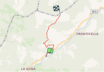
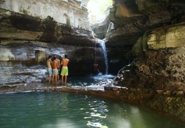
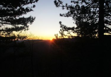
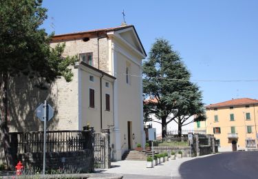
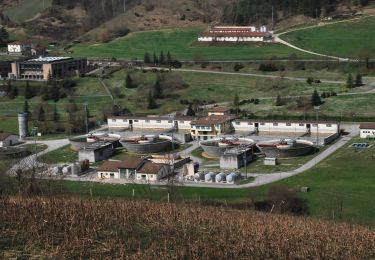
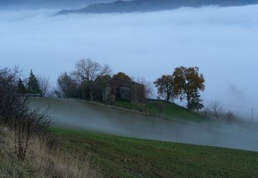
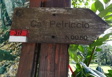
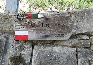
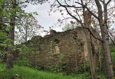
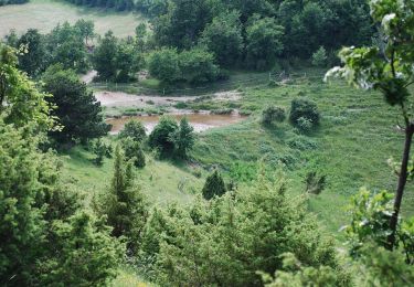
Tour Zu Fuß von 3,3 km verfügbar auf Emilia-Romagna, Forlì-Cesena, Premilcuore. Diese Tour wird von SityTrail - itinéraires balisés pédestres vorgeschlagen.
Beschreibung
Trail created by Unione di Comuni della Romagna Forlivese.
Ort
Land:
Italy
Region :
Emilia-Romagna
Abteilung/Provinz :
Forlì-Cesena
Kommune :
Premilcuore
Standort:
Unknown
Gehen Sie:(Dec)
Gehen Sie:(UTM)
724794 ; 4875190 (32T) N.
Kommentare
Touren in der Umgebung
![Tour Zu Fuß Premilcuore - I Monti Gemelli - Photo](https://media.geolcdn.com/t/375/260/e35ec321-e18a-4c29-ab8e-f5ba2d44aa2f.jpeg&format=jpg&maxdim=2)
![Zu Fuß Zu Fuß](https://static1.geolcdn.com/sitytour/trail-icons/100.png)
I Monti Gemelli
Zu Fuß
Medium
Premilcuore,
Emilia-Romagna,
Forlì-Cesena,
Italy
![](/images/other/stat-length.png)
16,9 km | 30 km-effort
6h 42min
![](https://static1.geolcdn.com/siteimages/upload/files/16400158638029165_repeat_loop_refresh_sync_direction_icon.png)
Ja
![Tour Zu Fuß Portico e San Benedetto - Da Bocconi verso i Monti Gemelli - Photo](https://media.geolcdn.com/t/375/260/c40944b8-5279-493d-97d9-4cd00eba42c5.jpeg&format=jpg&maxdim=2)
![Zu Fuß Zu Fuß](https://static1.geolcdn.com/sitytour/trail-icons/100.png)
Da Bocconi verso i Monti Gemelli
Zu Fuß
Medium
Portico e San Benedetto,
Emilia-Romagna,
Forlì-Cesena,
Italy
![](/images/other/stat-length.png)
11,2 km | 22 km-effort
4h 54min
![](https://static1.geolcdn.com/siteimages/upload/files/16400158638029165_repeat_loop_refresh_sync_direction_icon.png)
Nein
![Tour Zu Fuß Portico e San Benedetto - Valli selvagge tra Rabbi e Montone - Photo](https://media.geolcdn.com/t/375/260/53c89d03-85e0-435e-890b-ef4151cd30e6.jpeg&format=jpg&maxdim=2)
![Zu Fuß Zu Fuß](https://static1.geolcdn.com/sitytour/trail-icons/100.png)
Valli selvagge tra Rabbi e Montone
Zu Fuß
Medium
Portico e San Benedetto,
Emilia-Romagna,
Forlì-Cesena,
Italy
![](/images/other/stat-length.png)
15,6 km | 31 km-effort
7h 1min
![](https://static1.geolcdn.com/siteimages/upload/files/16400158638029165_repeat_loop_refresh_sync_direction_icon.png)
Nein
![Tour Zu Fuß Santa Sofia - IT-B4 - Photo](https://media.geolcdn.com/t/375/260/3603a1f7-12a6-43dc-9a52-23ac5480ff96.jpeg&format=jpg&maxdim=2)
![Zu Fuß Zu Fuß](https://static1.geolcdn.com/sitytour/trail-icons/100.png)
IT-B4
Zu Fuß
Einfach
Santa Sofia,
Emilia-Romagna,
Forlì-Cesena,
Italy
![](/images/other/stat-length.png)
5,4 km | 7,1 km-effort
1h 37min
![](https://static1.geolcdn.com/siteimages/upload/files/16400158638029165_repeat_loop_refresh_sync_direction_icon.png)
Nein
![Tour Zu Fuß Santa Sofia - IT-275 - Photo](https://media.geolcdn.com/t/375/260/d8424018-fbb1-49f3-b123-d1f903c6116c.jpeg&format=jpg&maxdim=2)
![Zu Fuß Zu Fuß](https://static1.geolcdn.com/sitytour/trail-icons/100.png)
IT-275
Zu Fuß
Einfach
Santa Sofia,
Emilia-Romagna,
Forlì-Cesena,
Italy
![](/images/other/stat-length.png)
4,8 km | 6,6 km-effort
1h 30min
![](https://static1.geolcdn.com/siteimages/upload/files/16400158638029165_repeat_loop_refresh_sync_direction_icon.png)
Nein
![Tour Zu Fuß Premilcuore - IT-317 - Photo](https://media.geolcdn.com/t/375/260/2009dfb3-7c53-4f62-be12-4d1352e393ee.jpeg&format=jpg&maxdim=2)
![Zu Fuß Zu Fuß](https://static1.geolcdn.com/sitytour/trail-icons/100.png)
IT-317
Zu Fuß
Einfach
Premilcuore,
Emilia-Romagna,
Forlì-Cesena,
Italy
![](/images/other/stat-length.png)
3,4 km | 4,9 km-effort
1h 6min
![](https://static1.geolcdn.com/siteimages/upload/files/16400158638029165_repeat_loop_refresh_sync_direction_icon.png)
Nein
![Tour Zu Fuß Premilcuore - IT-R6 - Photo](https://media.geolcdn.com/t/375/260/62f931be-a896-4a66-9160-1a37f988e90b.jpeg&format=jpg&maxdim=2)
![Zu Fuß Zu Fuß](https://static1.geolcdn.com/sitytour/trail-icons/100.png)
IT-R6
Zu Fuß
Einfach
Premilcuore,
Emilia-Romagna,
Forlì-Cesena,
Italy
![](/images/other/stat-length.png)
3,6 km | 8,5 km-effort
1h 56min
![](https://static1.geolcdn.com/siteimages/upload/files/16400158638029165_repeat_loop_refresh_sync_direction_icon.png)
Nein
![Tour Zu Fuß Santa Sofia - Il selvaggio Poggio Montironi - Photo](https://media.geolcdn.com/t/375/260/3f2209d1-7bc9-45b4-b30f-7c83e123323a.jpeg&format=jpg&maxdim=2)
![Zu Fuß Zu Fuß](https://static1.geolcdn.com/sitytour/trail-icons/100.png)
Il selvaggio Poggio Montironi
Zu Fuß
Einfach
Santa Sofia,
Emilia-Romagna,
Forlì-Cesena,
Italy
![](/images/other/stat-length.png)
11,2 km | 19,5 km-effort
4h 25min
![](https://static1.geolcdn.com/siteimages/upload/files/16400158638029165_repeat_loop_refresh_sync_direction_icon.png)
Ja
![Tour Zu Fuß Premilcuore - IT-R4I - Photo](https://media.geolcdn.com/t/375/260/a3334170-a6ea-4612-aee4-22fa9cdca395.jpeg&format=jpg&maxdim=2)
![Zu Fuß Zu Fuß](https://static1.geolcdn.com/sitytour/trail-icons/100.png)
IT-R4I
Zu Fuß
Einfach
Premilcuore,
Emilia-Romagna,
Forlì-Cesena,
Italy
![](/images/other/stat-length.png)
6,3 km | 11,9 km-effort
2h 42min
![](https://static1.geolcdn.com/siteimages/upload/files/16400158638029165_repeat_loop_refresh_sync_direction_icon.png)
Nein