![](/images/other/stat-length.png)
![Tour Zu Fuß Barbâtre - Les portes de l'île - Photo](https://media.geolcdn.com/t/1900/400/ext.pjpeg?maxdim=2&url=https%3A%2F%2Fmedia.geolcdn.com%2Ff%2F82a1d405-bb0f-46bc-9ffd-a50bc0af4a29.jpeg)
Les portes de l'île
SityTrail - itinéraires balisés pédestres
Tous les sentiers balisés d’Europe PRO
![Länge](/images/other/stat-length.png)
Länge
13,3 km
![Maximale Höhe](https://static1.geolcdn.com/siteimages/upload/files/1508320355ic_sort_altitude_max_24dp.png)
Maximale Höhe
13 m
![Positive Höhendifferenz](https://static1.geolcdn.com/siteimages/upload/files/1508320355ic_sort_den_pos_24dp.png)
Positive Höhendifferenz
53 m
![Km-Effort](/images/other/stat-length.png)
Km-Effort
14 km
![Min. Höhe](https://static1.geolcdn.com/siteimages/upload/files/1508320355ic_sort_altitude_min_24dp.png)
Min. Höhe
-2 m
![Negative Höhendifferenz](https://static1.geolcdn.com/siteimages/upload/files/1508320355ic_sort_den_neg_24dp.png)
Negative Höhendifferenz
50 m
![Boucle](https://static1.geolcdn.com/siteimages/upload/files/16400158638029165_repeat_loop_refresh_sync_direction_icon.png)
Boucle
Ja
Kennzeichnung
Erstellungsdatum :
2022-02-15 02:59:51.754
Letzte Änderung :
2022-03-02 11:59:48.681
![Zu Fuß](https://static1.geolcdn.com/sitytour/trail-icons/100.png)
3h11
Schwierigkeit : Einfach
![Scannen Sie diesen QR-Code, um die Tour in der SityTrail-Anwendung zu öffnen](https://capi.geolives.com/qq0zvz2zws4bq2lad0pu/sitytour/trails/3114373/qr.png?size=200)
Kostenlosegpshiking-Anwendung
Über SityTrail
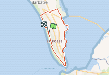
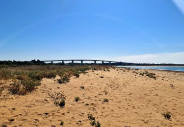
Tour Zu Fuß von 13,3 km verfügbar auf Pays de la Loire, Vendée, Barbâtre. Diese Tour wird von SityTrail - itinéraires balisés pédestres vorgeschlagen.
Beschreibung
Symbol: balisage jaune
Ort
Land:
France
Region :
Pays de la Loire
Abteilung/Provinz :
Vendée
Kommune :
Barbâtre
Standort:
Unknown
Gehen Sie:(Dec)
Gehen Sie:(UTM)
563305 ; 5196697 (30T) N.
Kommentare
Touren in der Umgebung
![Tour Mountainbike Barbâtre - Ile de Noirmoutier - Photo](https://media.geolcdn.com/t/375/260/ext.jpg?maxdim=2&url=https%3A%2F%2Fservices.sitytrail.com%2FGeolivesWS%2FDownloadMedia.ashx%3FTrailID%3D100765%26Media%3D275_6.jpg)
![Mountainbike Mountainbike](https://static1.geolcdn.com/sitytour/trail-icons/202.png)
Ile de Noirmoutier
Mountainbike
Medium
(3)
Barbâtre,
Pays de la Loire,
Vendée,
France
![](/images/other/stat-length.png)
31 km | 32 km-effort
2h 0min
![](https://static1.geolcdn.com/siteimages/upload/files/16400158638029165_repeat_loop_refresh_sync_direction_icon.png)
Nein
![Tour Wandern Barbâtre - Jeun et Rando J5 - Passage du gois et réserve naturelle - Photo](https://media.geolcdn.com/t/375/260/ext.jpg?maxdim=2&url=https%3A%2F%2Fmedia.geolcdn.com%2Ff%2F63982714-02ad-4988-81a1-3136e11c938c.jpg)
![Wandern Wandern](https://static1.geolcdn.com/sitytour/trail-icons/101.png)
Jeun et Rando J5 - Passage du gois et réserve naturelle
Wandern
Sehr leicht
Barbâtre,
Pays de la Loire,
Vendée,
France
![](/images/other/stat-length.png)
10,1 km | 10,5 km-effort
2h 4min
![](https://static1.geolcdn.com/siteimages/upload/files/16400158638029165_repeat_loop_refresh_sync_direction_icon.png)
Ja
![Tour Hybrid-Bike La Barre-de-Monts - La Barre-de-Monts-Boucle du Daviaud - Photo](https://media.geolcdn.com/t/375/260/ext.jpg?maxdim=2&url=https%3A%2F%2Fmedia.geolcdn.com%2Ff%2Ff7185e7c-5ab5-482f-bfdb-40b3b1459f78.jpg)
![Hybrid-Bike Hybrid-Bike](https://static1.geolcdn.com/sitytour/trail-icons/203.png)
La Barre-de-Monts-Boucle du Daviaud
Hybrid-Bike
Einfach
La Barre-de-Monts,
Pays de la Loire,
Vendée,
France
![](/images/other/stat-length.png)
13,2 km | 13,6 km-effort
1h 28min
![](https://static1.geolcdn.com/siteimages/upload/files/16400158638029165_repeat_loop_refresh_sync_direction_icon.png)
Ja
![Tour Wandern La Barre-de-Monts - ostréiculteurs - Photo](https://media.geolcdn.com/t/375/260/ext.jpg?maxdim=2&url=https%3A%2F%2Fmedia.geolcdn.com%2Ff%2F072a44b0-c952-4e8b-9f56-93c4ce319af4.jpg)
![Wandern Wandern](https://static1.geolcdn.com/sitytour/trail-icons/101.png)
ostréiculteurs
Wandern
Medium
La Barre-de-Monts,
Pays de la Loire,
Vendée,
France
![](/images/other/stat-length.png)
6 km | 6,5 km-effort
1h 46min
![](https://static1.geolcdn.com/siteimages/upload/files/16400158638029165_repeat_loop_refresh_sync_direction_icon.png)
Nein
![Tour Wandern Barbâtre - le pont, moulin des yuccas, le gois, le pont de Noirmoutier - Photo](https://media.geolcdn.com/t/375/260/ext.jpg?maxdim=2&url=https%3A%2F%2Fservices.sitytrail.com%2FGeolivesWS%2FDownloadMedia.ashx%3FTrailID%3D153890%26Media%3D20120916132328.jpg)
![Wandern Wandern](https://static1.geolcdn.com/sitytour/trail-icons/101.png)
le pont, moulin des yuccas, le gois, le pont de Noirmoutier
Wandern
Einfach
Barbâtre,
Pays de la Loire,
Vendée,
France
![](/images/other/stat-length.png)
16,9 km | 17,7 km-effort
3h 57min
![](https://static1.geolcdn.com/siteimages/upload/files/16400158638029165_repeat_loop_refresh_sync_direction_icon.png)
Ja
![Tour Rollerblading Barbâtre - Ile de Noirmoutier - Photo](https://media.geolcdn.com/t/375/260/ext.jpg?maxdim=2&url=https%3A%2F%2Fservices.sitytrail.com%2FGeolivesWS%2FDownloadMedia.ashx%3FTrailID%3D100766%26Media%3D275_3.jpg)
![Rollerblading Rollerblading](https://static1.geolcdn.com/sitytour/trail-icons/901.png)
Ile de Noirmoutier
Rollerblading
Medium
Barbâtre,
Pays de la Loire,
Vendée,
France
![](/images/other/stat-length.png)
31 km | 32 km-effort
3h 0min
![](https://static1.geolcdn.com/siteimages/upload/files/16400158638029165_repeat_loop_refresh_sync_direction_icon.png)
Nein
![Tour Radtourismus La Guérinière - Tour de l’île de Noirmoutier sud - Photo](https://media.geolcdn.com/t/375/260/ext.jpg?maxdim=2&url=https%3A%2F%2Fmedia.geolcdn.com%2Ff%2F7a53a226-ce11-404c-b206-aaf601aeca67.jpg)
![Radtourismus Radtourismus](https://static1.geolcdn.com/sitytour/trail-icons/204.png)
Tour de l’île de Noirmoutier sud
Radtourismus
Medium
La Guérinière,
Pays de la Loire,
Vendée,
France
![](/images/other/stat-length.png)
23 km | 24 km-effort
1h 47min
![](https://static1.geolcdn.com/siteimages/upload/files/16400158638029165_repeat_loop_refresh_sync_direction_icon.png)
Ja
![Tour Wandern La Barre-de-Monts - Fromentine - Photo](https://media.geolcdn.com/t/375/260/ext.jpg?maxdim=2&url=https%3A%2F%2Fmedia.geolcdn.com%2Ff%2F8e53e7f5-6db2-45d9-8c0c-82e686135ce0.jpg)
![Wandern Wandern](https://static1.geolcdn.com/sitytour/trail-icons/101.png)
Fromentine
Wandern
Medium
La Barre-de-Monts,
Pays de la Loire,
Vendée,
France
![](/images/other/stat-length.png)
17,1 km | 18,1 km-effort
5h 1min
![](https://static1.geolcdn.com/siteimages/upload/files/16400158638029165_repeat_loop_refresh_sync_direction_icon.png)
Ja
![Tour Wandern La Barre-de-Monts - Le phare - Photo](https://media.geolcdn.com/t/375/260/ext.jpg?maxdim=2&url=https%3A%2F%2Fmedia.geolcdn.com%2Ff%2F7a62d1a4-1739-4153-ae0a-3f1795228efe.jpg)
![Wandern Wandern](https://static1.geolcdn.com/sitytour/trail-icons/101.png)
Le phare
Wandern
Medium
La Barre-de-Monts,
Pays de la Loire,
Vendée,
France
![](/images/other/stat-length.png)
7,8 km | 8,6 km-effort
2h 29min
![](https://static1.geolcdn.com/siteimages/upload/files/16400158638029165_repeat_loop_refresh_sync_direction_icon.png)
Ja