![](/images/other/stat-length.png)
![Tour Zu Fuß Saint-Rivoal - Landes et Tourbières - Photo](https://media.geolcdn.com/t/1900/400/c5b98d78-e599-4d6a-ae17-467d21882015.jpeg&format=pjpeg&maxdim=2)
Landes et Tourbières
SityTrail - itinéraires balisés pédestres
Tous les sentiers balisés d’Europe GUIDE+
![Länge](/images/other/stat-length.png)
Länge
11,8 km
![Maximale Höhe](https://static1.geolcdn.com/siteimages/upload/files/1508320355ic_sort_altitude_max_24dp.png)
Maximale Höhe
380 m
![Positive Höhendifferenz](https://static1.geolcdn.com/siteimages/upload/files/1508320355ic_sort_den_pos_24dp.png)
Positive Höhendifferenz
161 m
![Km-Effort](/images/other/stat-length.png)
Km-Effort
14,1 km
![Min. Höhe](https://static1.geolcdn.com/siteimages/upload/files/1508320355ic_sort_altitude_min_24dp.png)
Min. Höhe
225 m
![Negative Höhendifferenz](https://static1.geolcdn.com/siteimages/upload/files/1508320355ic_sort_den_neg_24dp.png)
Negative Höhendifferenz
197 m
![Boucle](https://static1.geolcdn.com/siteimages/upload/files/16400158638029165_repeat_loop_refresh_sync_direction_icon.png)
Boucle
Nein
Kennzeichnung
Erstellungsdatum :
2022-02-15 02:49:58.656
Letzte Änderung :
2022-03-02 11:40:41.202
![Zu Fuß](https://static1.geolcdn.com/sitytour/trail-icons/100.png)
3h12
Schwierigkeit : Einfach
![Scannen Sie diesen QR-Code, um die Tour in der SityTrail-Anwendung zu öffnen](https://capi.geolives.com/qq0zvz2zws4bq2lad0pu/sitytour/trails/3114281/qr.png?size=200)
Kostenlosegpshiking-Anwendung
Über SityTrail
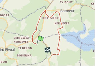
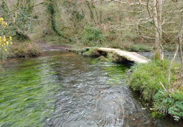
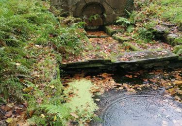
Tour Zu Fuß von 11,8 km verfügbar auf Bretagne, Finistère, Saint-Rivoal. Diese Tour wird von SityTrail - itinéraires balisés pédestres vorgeschlagen.
Beschreibung
Encore marquée que le terrain en 2019
Ort
Land:
France
Region :
Bretagne
Abteilung/Provinz :
Finistère
Kommune :
Saint-Rivoal
Standort:
Unknown
Gehen Sie:(Dec)
Gehen Sie:(UTM)
429258 ; 5356036 (30U) N.
Kommentare
Touren in der Umgebung
![Tour Zu Fuß Commana - Tour du Lac du Drennec - Photo](https://media.geolcdn.com/t/375/260/217e9b5b-dfd1-47dd-bef6-7dae7db515fe.jpeg&format=jpg&maxdim=2)
![Zu Fuß Zu Fuß](https://static1.geolcdn.com/sitytour/trail-icons/100.png)
Tour du Lac du Drennec
Zu Fuß
Einfach
Commana,
Bretagne,
Finistère,
France
![](/images/other/stat-length.png)
6,5 km | 7,5 km-effort
1h 42min
![](https://static1.geolcdn.com/siteimages/upload/files/16400158638029165_repeat_loop_refresh_sync_direction_icon.png)
Ja
![Tour Zu Fuß Botmeur - Brasparts Circuit des landes et tourbières - Photo](https://media.geolcdn.com/t/375/260/98159458-f3c1-4612-bed6-39d858fe0671.jpeg&format=jpg&maxdim=2)
![Zu Fuß Zu Fuß](https://static1.geolcdn.com/sitytour/trail-icons/100.png)
Brasparts Circuit des landes et tourbières
Zu Fuß
Einfach
Botmeur,
Bretagne,
Finistère,
France
![](/images/other/stat-length.png)
3,7 km | 4,2 km-effort
57min
![](https://static1.geolcdn.com/siteimages/upload/files/16400158638029165_repeat_loop_refresh_sync_direction_icon.png)
Nein
![Tour Wandern Saint-Rivoal - GR_37_FA_12_St-Rivoal_Loperec_20200811 - Photo](https://media.geolcdn.com/t/375/260/f5ace299-8c7f-44c6-82e9-6da866129eef.jpg&format=jpg&maxdim=2)
![Wandern Wandern](https://static1.geolcdn.com/sitytour/trail-icons/101.png)
GR_37_FA_12_St-Rivoal_Loperec_20200811
Wandern
Medium
Saint-Rivoal,
Bretagne,
Finistère,
France
![](/images/other/stat-length.png)
15,3 km | 20 km-effort
4h 17min
![](https://static1.geolcdn.com/siteimages/upload/files/16400158638029165_repeat_loop_refresh_sync_direction_icon.png)
Nein
![Tour Wandern Sizun - Tour du lac du Drennec - Photo](https://media.geolcdn.com/t/375/260/ext.jpg?maxdim=2&url=https%3A%2F%2Fservices.sitytrail.com%2FGeolivesWS%2FDownloadMedia.ashx%3FTrailID%3D656775%26Media%3Dfix__20161106144537.jpg)
![Wandern Wandern](https://static1.geolcdn.com/sitytour/trail-icons/101.png)
Tour du lac du Drennec
Wandern
Sehr leicht
Sizun,
Bretagne,
Finistère,
France
![](/images/other/stat-length.png)
6,6 km | 7,6 km-effort
1h 42min
![](https://static1.geolcdn.com/siteimages/upload/files/16400158638029165_repeat_loop_refresh_sync_direction_icon.png)
Ja
![Tour Pferd Saint-Rivoal - Autour de St Rivoal par le lac du Drennec - Photo](https://media.geolcdn.com/t/375/260/ext.jpg?maxdim=2&url=https%3A%2F%2Fservices.sitytrail.com%2FGeolivesWS%2FDownloadMedia.ashx%3FTrailID%3D317263%26Media%3D16448_6.jpg)
![Pferd Pferd](https://static1.geolcdn.com/sitytour/trail-icons/300.png)
Autour de St Rivoal par le lac du Drennec
Pferd
Schwierig
Saint-Rivoal,
Bretagne,
Finistère,
France
![](/images/other/stat-length.png)
30 km | 38 km-effort
5h 0min
![](https://static1.geolcdn.com/siteimages/upload/files/16400158638029165_repeat_loop_refresh_sync_direction_icon.png)
Ja
![Tour Wandern Botmeur - Roc'h Bichourel - Botmeur - Photo](https://media.geolcdn.com/t/375/260/ext.jpg?maxdim=2&url=https%3A%2F%2Fservices.sitytrail.com%2FGeolivesWS%2FDownloadMedia.ashx%3FTrailID%3D191436%26Media%3D15024_3.jpg)
![Wandern Wandern](https://static1.geolcdn.com/sitytour/trail-icons/101.png)
Roc'h Bichourel - Botmeur
Wandern
Medium
Botmeur,
Bretagne,
Finistère,
France
![](/images/other/stat-length.png)
8,3 km | 10,2 km-effort
2h 30min
![](https://static1.geolcdn.com/siteimages/upload/files/16400158638029165_repeat_loop_refresh_sync_direction_icon.png)
Ja
![Tour Wandern Sizun - St Cadou et le Lac du Drennec - Sizun - Photo](https://media.geolcdn.com/t/375/260/ext.jpg?maxdim=2&url=https%3A%2F%2Fservices.sitytrail.com%2FGeolivesWS%2FDownloadMedia.ashx%3FTrailID%3D173020%26Media%3D14524_5.jpg)
![Wandern Wandern](https://static1.geolcdn.com/sitytour/trail-icons/101.png)
St Cadou et le Lac du Drennec - Sizun
Wandern
Schwierig
(1)
Sizun,
Bretagne,
Finistère,
France
![](/images/other/stat-length.png)
16,6 km | 21 km-effort
4h 10min
![](https://static1.geolcdn.com/siteimages/upload/files/16400158638029165_repeat_loop_refresh_sync_direction_icon.png)
Ja
![Tour Wandern Sizun - SAINT CADOU - Photo](https://media.geolcdn.com/t/375/260/fef4f49b-990f-4a0a-b8a9-f239bc0349c0.jpg&format=jpg&maxdim=2)
![Wandern Wandern](https://static1.geolcdn.com/sitytour/trail-icons/101.png)
![Tour Wandern Sizun - st cadou les carrieres - Photo](https://media.geolcdn.com/t/375/260/5d7228d4-6a1f-4a10-b8d6-e1a199ab0f3f.jpg&format=jpg&maxdim=2)
![Wandern Wandern](https://static1.geolcdn.com/sitytour/trail-icons/101.png)
st cadou les carrieres
Wandern
Schwierig
Sizun,
Bretagne,
Finistère,
France
![](/images/other/stat-length.png)
12,9 km | 16,4 km-effort
3h 16min
![](https://static1.geolcdn.com/siteimages/upload/files/16400158638029165_repeat_loop_refresh_sync_direction_icon.png)
Ja