![](/images/other/stat-length.png)
![Tour Zu Fuß Beaumont - Sentier botanique de Beaumont - Photo](https://media.geolcdn.com/t/1900/400/ext.pjpeg?maxdim=2&url=https%3A%2F%2Fstatic1.geolcdn.com%2Fsiteimages%2Fupload%2Ffiles%2F1545311037marcheuse_200dpi.jpg)
Sentier botanique de Beaumont
SityTrail - itinéraires balisés pédestres
Tous les sentiers balisés d’Europe GUIDE+
![Länge](/images/other/stat-length.png)
Länge
5,4 km
![Maximale Höhe](https://static1.geolcdn.com/siteimages/upload/files/1508320355ic_sort_altitude_max_24dp.png)
Maximale Höhe
502 m
![Positive Höhendifferenz](https://static1.geolcdn.com/siteimages/upload/files/1508320355ic_sort_den_pos_24dp.png)
Positive Höhendifferenz
302 m
![Km-Effort](/images/other/stat-length.png)
Km-Effort
9,5 km
![Min. Höhe](https://static1.geolcdn.com/siteimages/upload/files/1508320355ic_sort_altitude_min_24dp.png)
Min. Höhe
263 m
![Negative Höhendifferenz](https://static1.geolcdn.com/siteimages/upload/files/1508320355ic_sort_den_neg_24dp.png)
Negative Höhendifferenz
310 m
![Boucle](https://static1.geolcdn.com/siteimages/upload/files/16400158638029165_repeat_loop_refresh_sync_direction_icon.png)
Boucle
Ja
Kennzeichnung
Erstellungsdatum :
2022-02-15 02:32:36.432
Letzte Änderung :
2022-03-02 11:19:03.503
![Zu Fuß](https://static1.geolcdn.com/sitytour/trail-icons/100.png)
2h09
Schwierigkeit : Einfach
![Scannen Sie diesen QR-Code, um die Tour in der SityTrail-Anwendung zu öffnen](https://capi.geolives.com/qq0zvz2zws4bq2lad0pu/sitytour/trails/3114019/qr.png?size=200)
Kostenlosegpshiking-Anwendung
Über SityTrail
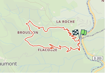
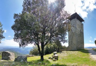
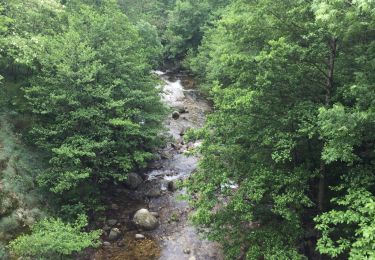
Tour Zu Fuß von 5,4 km verfügbar auf Auvergne-Rhone-Alpen, Ardèche, Beaumont. Diese Tour wird von SityTrail - itinéraires balisés pédestres vorgeschlagen.
Beschreibung
Trail created by Association Vie et Tourisme.
Ort
Land:
France
Region :
Auvergne-Rhone-Alpen
Abteilung/Provinz :
Ardèche
Kommune :
Beaumont
Standort:
Unknown
Gehen Sie:(Dec)
Gehen Sie:(UTM)
594543 ; 4932783 (31T) N.
Kommentare
Touren in der Umgebung
![Tour Mountainbike Joannas - roubreau col de bauzon - Photo](https://media.geolcdn.com/t/375/260/ext.jpg?maxdim=2&url=https%3A%2F%2Fservices.sitytrail.com%2FGeolivesWS%2FDownloadMedia.ashx%3FTrailID%3D207936%26Media%3Dfix__20130726114045.jpg)
![Mountainbike Mountainbike](https://static1.geolcdn.com/sitytour/trail-icons/202.png)
roubreau col de bauzon
Mountainbike
Sehr schwierig
(1)
Joannas,
Auvergne-Rhone-Alpen,
Ardèche,
France
![](/images/other/stat-length.png)
65 km | 93 km-effort
6h 20min
![](https://static1.geolcdn.com/siteimages/upload/files/16400158638029165_repeat_loop_refresh_sync_direction_icon.png)
Ja
![Tour Wandern Saint-André-Lachamp - le pont de la brousse - Photo](https://media.geolcdn.com/t/375/260/ext.jpg?maxdim=2&url=https%3A%2F%2Fservices.sitytrail.com%2FGeolivesWS%2FDownloadMedia.ashx%3FTrailID%3D264953%26Media%3Dfix__20140408144329.jpg)
![Wandern Wandern](https://static1.geolcdn.com/sitytour/trail-icons/101.png)
le pont de la brousse
Wandern
Schwierig
(2)
Saint-André-Lachamp,
Auvergne-Rhone-Alpen,
Ardèche,
France
![](/images/other/stat-length.png)
21 km | 34 km-effort
8h 2min
![](https://static1.geolcdn.com/siteimages/upload/files/16400158638029165_repeat_loop_refresh_sync_direction_icon.png)
Ja
![Tour Wandern Rocles - 07 pissas bouteillac - Photo](https://media.geolcdn.com/t/375/260/0353abc6-656e-4020-b88a-baa112666994.jpg&format=jpg&maxdim=2)
![Wandern Wandern](https://static1.geolcdn.com/sitytour/trail-icons/101.png)
07 pissas bouteillac
Wandern
Medium
Rocles,
Auvergne-Rhone-Alpen,
Ardèche,
France
![](/images/other/stat-length.png)
11,8 km | 23 km-effort
7h 12min
![](https://static1.geolcdn.com/siteimages/upload/files/16400158638029165_repeat_loop_refresh_sync_direction_icon.png)
Ja
![Tour Wandern Vernon - Vernon Tour de Brison 20km - Photo](https://media.geolcdn.com/t/375/260/1d443c17-2f68-4a33-bd33-d422959f5b68.jpg&format=jpg&maxdim=2)
![Wandern Wandern](https://static1.geolcdn.com/sitytour/trail-icons/101.png)
Vernon Tour de Brison 20km
Wandern
Schwierig
Vernon,
Auvergne-Rhone-Alpen,
Ardèche,
France
![](/images/other/stat-length.png)
19,9 km | 29 km-effort
6h 0min
![](https://static1.geolcdn.com/siteimages/upload/files/16400158638029165_repeat_loop_refresh_sync_direction_icon.png)
Ja
![Tour Wandern Vernon - 07 Vernon 25 02 2021 - Photo](https://media.geolcdn.com/t/375/260/bf74ca26-a5ee-4a75-afb9-c1a8b51eb415.jpg&format=jpg&maxdim=2)
![Wandern Wandern](https://static1.geolcdn.com/sitytour/trail-icons/101.png)
07 Vernon 25 02 2021
Wandern
Medium
Vernon,
Auvergne-Rhone-Alpen,
Ardèche,
France
![](/images/other/stat-length.png)
16,7 km | 25 km-effort
4h 10min
![](https://static1.geolcdn.com/siteimages/upload/files/16400158638029165_repeat_loop_refresh_sync_direction_icon.png)
Ja
![Tour Wandern Sanilhac - 07 la tour de Brison 27/11/24 - Photo](https://media.geolcdn.com/t/375/260/f46c7656-7f7e-42ee-ae50-cea3d164b83d.jpg&format=jpg&maxdim=2)
![Wandern Wandern](https://static1.geolcdn.com/sitytour/trail-icons/101.png)
07 la tour de Brison 27/11/24
Wandern
Sehr schwierig
Sanilhac,
Auvergne-Rhone-Alpen,
Ardèche,
France
![](/images/other/stat-length.png)
14,8 km | 21 km-effort
6h 23min
![](https://static1.geolcdn.com/siteimages/upload/files/16400158638029165_repeat_loop_refresh_sync_direction_icon.png)
Ja
![Tour Wandern Sanilhac - ARDECHE . SANILLAC.LA TOUR DE BRISON O N - Photo](https://media.geolcdn.com/t/375/260/475c36dd-0da5-4970-a540-5a2ff04c11f8.jpg&format=jpg&maxdim=2)
![Wandern Wandern](https://static1.geolcdn.com/sitytour/trail-icons/101.png)
ARDECHE . SANILLAC.LA TOUR DE BRISON O N
Wandern
Schwierig
Sanilhac,
Auvergne-Rhone-Alpen,
Ardèche,
France
![](/images/other/stat-length.png)
14,6 km | 21 km-effort
4h 37min
![](https://static1.geolcdn.com/siteimages/upload/files/16400158638029165_repeat_loop_refresh_sync_direction_icon.png)
Ja
![Tour Zu Fuß Vernon - Vernon: La Tour de Brison. 20km - Photo](https://media.geolcdn.com/t/375/260/a0f7fd93-7ab0-4ce0-97c8-d7d4367da763.jpg&format=jpg&maxdim=2)
![Zu Fuß Zu Fuß](https://static1.geolcdn.com/sitytour/trail-icons/100.png)
Vernon: La Tour de Brison. 20km
Zu Fuß
Schwierig
Vernon,
Auvergne-Rhone-Alpen,
Ardèche,
France
![](/images/other/stat-length.png)
19,7 km | 29 km-effort
6h 28min
![](https://static1.geolcdn.com/siteimages/upload/files/16400158638029165_repeat_loop_refresh_sync_direction_icon.png)
Ja
![Tour Wandern Valgorge - Chastanet le tour...allongé - Photo](https://media.geolcdn.com/t/375/260/4e04f859-dfe3-49c8-95a9-a1e41dd5f53c.jpg&format=jpg&maxdim=2)
![Wandern Wandern](https://static1.geolcdn.com/sitytour/trail-icons/101.png)
Chastanet le tour...allongé
Wandern
Medium
Valgorge,
Auvergne-Rhone-Alpen,
Ardèche,
France
![](/images/other/stat-length.png)
8,3 km | 11,2 km-effort
3h 7min
![](https://static1.geolcdn.com/siteimages/upload/files/16400158638029165_repeat_loop_refresh_sync_direction_icon.png)
Nein