![](/images/other/stat-length.png)
![Tour Zu Fuß Ville-Saint-Jacques - Basse vallée de l'Orvanne - Photo](https://media.geolcdn.com/t/1900/400/82137b8f-59f6-42a4-8e1b-17c82b952e9a.jpeg&format=pjpeg&maxdim=2)
Basse vallée de l'Orvanne
SityTrail - itinéraires balisés pédestres
Tous les sentiers balisés d’Europe GUIDE+
![Länge](/images/other/stat-length.png)
Länge
16 km
![Maximale Höhe](https://static1.geolcdn.com/siteimages/upload/files/1508320355ic_sort_altitude_max_24dp.png)
Maximale Höhe
139 m
![Positive Höhendifferenz](https://static1.geolcdn.com/siteimages/upload/files/1508320355ic_sort_den_pos_24dp.png)
Positive Höhendifferenz
229 m
![Km-Effort](/images/other/stat-length.png)
Km-Effort
19,1 km
![Min. Höhe](https://static1.geolcdn.com/siteimages/upload/files/1508320355ic_sort_altitude_min_24dp.png)
Min. Höhe
65 m
![Negative Höhendifferenz](https://static1.geolcdn.com/siteimages/upload/files/1508320355ic_sort_den_neg_24dp.png)
Negative Höhendifferenz
229 m
![Boucle](https://static1.geolcdn.com/siteimages/upload/files/16400158638029165_repeat_loop_refresh_sync_direction_icon.png)
Boucle
Ja
Kennzeichnung
Erstellungsdatum :
2022-02-15 01:30:13.99
Letzte Änderung :
2022-03-02 10:05:37.891
![Zu Fuß](https://static1.geolcdn.com/sitytour/trail-icons/100.png)
4h20
Schwierigkeit : Einfach
![Scannen Sie diesen QR-Code, um die Tour in der SityTrail-Anwendung zu öffnen](https://capi.geolives.com/qq0zvz2zws4bq2lad0pu/sitytour/trails/3113311/qr.png?size=200)
Kostenlosegpshiking-Anwendung
Über SityTrail
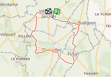
Tour Zu Fuß von 16 km verfügbar auf Île-de-France, Seine-et-Marne, Ville-Saint-Jacques. Diese Tour wird von SityTrail - itinéraires balisés pédestres vorgeschlagen.
Beschreibung
Trail created by Moret Seine & Loing.
Ort
Land:
France
Region :
Île-de-France
Abteilung/Provinz :
Seine-et-Marne
Kommune :
Ville-Saint-Jacques
Standort:
Unknown
Gehen Sie:(Dec)
Gehen Sie:(UTM)
492549 ; 5354028 (31U) N.
Kommentare
Touren in der Umgebung
![Tour Wandern Montereau-Fault-Yonne - Linéaire Montereau Moret via Flagy Villecerf Dormelles - Photo](https://media.geolcdn.com/t/375/260/fe0572c3-7eaf-4b6b-831c-73b9c6172b2e.jpg&format=jpg&maxdim=2)
![Wandern Wandern](https://static1.geolcdn.com/sitytour/trail-icons/101.png)
Linéaire Montereau Moret via Flagy Villecerf Dormelles
Wandern
Sehr schwierig
Montereau-Fault-Yonne,
Île-de-France,
Seine-et-Marne,
France
![](/images/other/stat-length.png)
34 km | 39 km-effort
6h 48min
![](https://static1.geolcdn.com/siteimages/upload/files/16400158638029165_repeat_loop_refresh_sync_direction_icon.png)
Nein
![Tour Zu Fuß Villemer - Maquis de Roys - Photo](https://media.geolcdn.com/t/375/260/70e58ce3-920c-43a7-ba54-1d0a3c2796ae.jpeg&format=jpg&maxdim=2)
![Zu Fuß Zu Fuß](https://static1.geolcdn.com/sitytour/trail-icons/100.png)
Maquis de Roys
Zu Fuß
Einfach
Villemer,
Île-de-France,
Seine-et-Marne,
France
![](/images/other/stat-length.png)
11,1 km | 13 km-effort
2h 56min
![](https://static1.geolcdn.com/siteimages/upload/files/16400158638029165_repeat_loop_refresh_sync_direction_icon.png)
Ja
![Tour Zu Fuß Moret-Loing-et-Orvanne - Entre Loing et Orvanne - Photo](https://media.geolcdn.com/t/375/260/03f6f91d-f2c6-4c29-98db-41cd58cd4804.jpeg&format=jpg&maxdim=2)
![Zu Fuß Zu Fuß](https://static1.geolcdn.com/sitytour/trail-icons/100.png)
Entre Loing et Orvanne
Zu Fuß
Einfach
Moret-Loing-et-Orvanne,
Île-de-France,
Seine-et-Marne,
France
![](/images/other/stat-length.png)
12,8 km | 15,1 km-effort
3h 26min
![](https://static1.geolcdn.com/siteimages/upload/files/16400158638029165_repeat_loop_refresh_sync_direction_icon.png)
Nein
![Tour Nordic Walking Villecerf - Autour de villecerf - Photo](https://media.geolcdn.com/t/375/260/ext.jpg?maxdim=2&url=https%3A%2F%2Fstatic1.geolcdn.com%2Fsiteimages%2Fupload%2Ffiles%2F1545311037marcheuse_200dpi.jpg)
![Nordic Walking Nordic Walking](https://static1.geolcdn.com/sitytour/trail-icons/102.png)
Autour de villecerf
Nordic Walking
(1)
Villecerf,
Île-de-France,
Seine-et-Marne,
France
![](/images/other/stat-length.png)
19,9 km | 23 km-effort
5h 12min
![](https://static1.geolcdn.com/siteimages/upload/files/16400158638029165_repeat_loop_refresh_sync_direction_icon.png)
Ja
![Tour Wandern Thoury-Férottes - 180111 EnCours - Photo](https://media.geolcdn.com/t/375/260/ext.jpg?maxdim=2&url=https%3A%2F%2Fservices.sitytrail.com%2FGeolivesWS%2FDownloadMedia.ashx%3FTrailID%3D886916%26Media%3Dfix__20180111125543.jpg)
![Wandern Wandern](https://static1.geolcdn.com/sitytour/trail-icons/101.png)
180111 EnCours
Wandern
Sehr leicht
Thoury-Férottes,
Île-de-France,
Seine-et-Marne,
France
![](/images/other/stat-length.png)
16,7 km | 19,7 km-effort
5h 20min
![](https://static1.geolcdn.com/siteimages/upload/files/16400158638029165_repeat_loop_refresh_sync_direction_icon.png)
Ja
![Tour Wandern Thoury-Férottes - Manu-170218 - Thoury-Dormelles - Photo](https://media.geolcdn.com/t/375/260/ext.jpg?maxdim=2&url=https%3A%2F%2Fservices.sitytrail.com%2FGeolivesWS%2FDownloadMedia.ashx%3FTrailID%3D700727%26Media%3D9d381017-48c9-49db-92ae-a1297989025d.jpg)
![Wandern Wandern](https://static1.geolcdn.com/sitytour/trail-icons/101.png)
Manu-170218 - Thoury-Dormelles
Wandern
Einfach
Thoury-Férottes,
Île-de-France,
Seine-et-Marne,
France
![](/images/other/stat-length.png)
15,8 km | 18,8 km-effort
4h 45min
![](https://static1.geolcdn.com/siteimages/upload/files/16400158638029165_repeat_loop_refresh_sync_direction_icon.png)
Ja
![Tour Wandern Dormelles - M&R-141219 - Dormelles - Photo](https://media.geolcdn.com/t/375/260/ext.jpg?maxdim=2&url=https%3A%2F%2Fservices.sitytrail.com%2FGeolivesWS%2FDownloadMedia.ashx%3FTrailID%3D371467%26Media%3D19e6ba95-3c6b-4ae7-8dc3-f0bbed2e93e0.jpg)
![Wandern Wandern](https://static1.geolcdn.com/sitytour/trail-icons/101.png)
M&R-141219 - Dormelles
Wandern
Einfach
Dormelles,
Île-de-France,
Seine-et-Marne,
France
![](/images/other/stat-length.png)
10,9 km | 12,7 km-effort
3h 0min
![](https://static1.geolcdn.com/siteimages/upload/files/16400158638029165_repeat_loop_refresh_sync_direction_icon.png)
Ja
![Tour Wandern Dormelles - M&R-131210 - Dormelles - Photo](https://media.geolcdn.com/t/375/260/ext.jpg?maxdim=2&url=https%3A%2F%2Fservices.sitytrail.com%2FGeolivesWS%2FDownloadMedia.ashx%3FTrailID%3D237422%26Media%3Dfix__20131210110652.jpg)
![Wandern Wandern](https://static1.geolcdn.com/sitytour/trail-icons/101.png)
M&R-131210 - Dormelles
Wandern
Sehr leicht
Dormelles,
Île-de-France,
Seine-et-Marne,
France
![](/images/other/stat-length.png)
16,1 km | 19,3 km-effort
4h 9min
![](https://static1.geolcdn.com/siteimages/upload/files/16400158638029165_repeat_loop_refresh_sync_direction_icon.png)
Ja
![Tour Wandern Montereau-Fault-Yonne - Seine et Yonne - Photo](https://media.geolcdn.com/t/375/260/ext.jpg?maxdim=2&url=https%3A%2F%2Fstatic1.geolcdn.com%2Fsiteimages%2Fupload%2Ffiles%2F1553511878bg_sport_marche.png)
![Wandern Wandern](https://static1.geolcdn.com/sitytour/trail-icons/101.png)
Seine et Yonne
Wandern
Medium
(3)
Montereau-Fault-Yonne,
Île-de-France,
Seine-et-Marne,
France
![](/images/other/stat-length.png)
22 km | 24 km-effort
Unbekannt
![](https://static1.geolcdn.com/siteimages/upload/files/16400158638029165_repeat_loop_refresh_sync_direction_icon.png)
Ja