![](/images/other/stat-length.png)
![Tour Zu Fuß Berkelland - Ommetje Haarlose Veld - Photo](https://media.geolcdn.com/t/1900/400/f31bd006-06fc-4bf7-a284-1202c5a24a09.jpeg&format=pjpeg&maxdim=2)
Ommetje Haarlose Veld
SityTrail - itinéraires balisés pédestres
Tous les sentiers balisés d’Europe GUIDE+
![Länge](/images/other/stat-length.png)
Länge
7,7 km
![Maximale Höhe](https://static1.geolcdn.com/siteimages/upload/files/1508320355ic_sort_altitude_max_24dp.png)
Maximale Höhe
28 m
![Positive Höhendifferenz](https://static1.geolcdn.com/siteimages/upload/files/1508320355ic_sort_den_pos_24dp.png)
Positive Höhendifferenz
45 m
![Km-Effort](/images/other/stat-length.png)
Km-Effort
8,3 km
![Min. Höhe](https://static1.geolcdn.com/siteimages/upload/files/1508320355ic_sort_altitude_min_24dp.png)
Min. Höhe
15 m
![Negative Höhendifferenz](https://static1.geolcdn.com/siteimages/upload/files/1508320355ic_sort_den_neg_24dp.png)
Negative Höhendifferenz
45 m
![Boucle](https://static1.geolcdn.com/siteimages/upload/files/16400158638029165_repeat_loop_refresh_sync_direction_icon.png)
Boucle
Ja
Kennzeichnung
Erstellungsdatum :
2022-02-14 15:54:14.754
Letzte Änderung :
2022-02-14 15:54:14.754
![Zu Fuß](https://static1.geolcdn.com/sitytour/trail-icons/100.png)
1h53
Schwierigkeit : Einfach
![Scannen Sie diesen QR-Code, um die Tour in der SityTrail-Anwendung zu öffnen](https://capi.geolives.com/qq0zvz2zws4bq2lad0pu/sitytour/trails/3110925/qr.png?size=200)
Kostenlosegpshiking-Anwendung
Über SityTrail
Tour Zu Fuß von 7,7 km verfügbar auf Geldern, Unbekannt, Berkelland. Diese Tour wird von SityTrail - itinéraires balisés pédestres vorgeschlagen.
Beschreibung
Trail created by Landschapsbeheer Gelderland.
Website: https://landschapsbeheergelderland.nl/wp-content/uploads/haarfolder-dv.pdf
Ort
Land:
Netherlands
Region :
Geldern
Abteilung/Provinz :
Unbekannt
Kommune :
Berkelland
Standort:
Unknown
Gehen Sie:(Dec)
Gehen Sie:(UTM)
334346 ; 5776323 (32U) N.
Kommentare
Touren in der Umgebung
![Tour Zu Fuß Berkelland - Drielindenkamproute - Photo](https://media.geolcdn.com/t/375/260/8a310e53-14c7-4dda-b0c7-5e4de058b4c6.jpeg&format=jpg&maxdim=2)
![Zu Fuß Zu Fuß](https://static1.geolcdn.com/sitytour/trail-icons/100.png)
Drielindenkamproute
Zu Fuß
Einfach
Berkelland,
Geldern,
Unbekannt,
Netherlands
![](/images/other/stat-length.png)
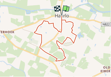
4,2 km | 4,4 km-effort
1h 0min
![](https://static1.geolcdn.com/siteimages/upload/files/16400158638029165_repeat_loop_refresh_sync_direction_icon.png)
Ja
![Tour Zu Fuß Berkelland - Needse Achterveld en 't Vleer - Photo](https://media.geolcdn.com/t/375/260/dev_226d566f-69b2-4b99-99ca-a8aa6e524cf4.jpeg&format=jpg&maxdim=2)
![Zu Fuß Zu Fuß](https://static1.geolcdn.com/sitytour/trail-icons/100.png)
Needse Achterveld en 't Vleer
Zu Fuß
Einfach
Berkelland,
Geldern,
Unbekannt,
Netherlands
![](/images/other/stat-length.png)
8,9 km | 9,7 km-effort
2h 12min
![](https://static1.geolcdn.com/siteimages/upload/files/16400158638029165_repeat_loop_refresh_sync_direction_icon.png)
Ja
![Tour Motor Berkelland - a-gelderland-5-biker-treffs - Photo](https://media.geolcdn.com/t/375/260/ext.jpg?maxdim=2&url=https%3A%2F%2Fstatic1.geolcdn.com%2Fsiteimages%2Fupload%2Ffiles%2F15247431544x4.jpg)
![Motor Motor](https://static1.geolcdn.com/sitytour/trail-icons/400.png)
a-gelderland-5-biker-treffs
Motor
Sehr leicht
Berkelland,
Geldern,
Unbekannt,
Netherlands
![](/images/other/stat-length.png)
176 km | 194 km-effort
Unbekannt
![](https://static1.geolcdn.com/siteimages/upload/files/16400158638029165_repeat_loop_refresh_sync_direction_icon.png)
Ja
![Tour Fahrrad Berkelland - Gelderland - Berkelland 5 - Photo](https://media.geolcdn.com/t/375/260/ext.jpg?maxdim=2&url=https%3A%2F%2Fstatic1.geolcdn.com%2Fsiteimages%2Fupload%2Ffiles%2F1524743154velo.jpg)
![Fahrrad Fahrrad](https://static1.geolcdn.com/sitytour/trail-icons/200.png)
Gelderland - Berkelland 5
Fahrrad
Sehr leicht
Berkelland,
Geldern,
Unbekannt,
Netherlands
![](/images/other/stat-length.png)
32 km | 34 km-effort
Unbekannt
![](https://static1.geolcdn.com/siteimages/upload/files/16400158638029165_repeat_loop_refresh_sync_direction_icon.png)
Ja
![Tour Fahrrad Berkelland - f-gelderland-borculo-en-buurtschappen - Photo](https://media.geolcdn.com/t/375/260/ext.jpg?maxdim=2&url=https%3A%2F%2Fstatic1.geolcdn.com%2Fsiteimages%2Fupload%2Ffiles%2F1524743154velo.jpg)
![Fahrrad Fahrrad](https://static1.geolcdn.com/sitytour/trail-icons/200.png)
f-gelderland-borculo-en-buurtschappen
Fahrrad
Sehr leicht
Berkelland,
Geldern,
Unbekannt,
Netherlands
![](/images/other/stat-length.png)
30 km | 32 km-effort
Unbekannt
![](https://static1.geolcdn.com/siteimages/upload/files/16400158638029165_repeat_loop_refresh_sync_direction_icon.png)
Ja
![Tour Fahrrad Berkelland - f-gelderland-anwb-veldenroute - Photo](https://media.geolcdn.com/t/375/260/ext.jpg?maxdim=2&url=https%3A%2F%2Fstatic1.geolcdn.com%2Fsiteimages%2Fupload%2Ffiles%2F1524743154velo.jpg)
![Fahrrad Fahrrad](https://static1.geolcdn.com/sitytour/trail-icons/200.png)
f-gelderland-anwb-veldenroute
Fahrrad
Sehr leicht
Berkelland,
Geldern,
Unbekannt,
Netherlands
![](/images/other/stat-length.png)
63 km | 67 km-effort
Unbekannt
![](https://static1.geolcdn.com/siteimages/upload/files/16400158638029165_repeat_loop_refresh_sync_direction_icon.png)
Ja
![Tour Wandern Berkelland - Gelderland - Rond Eibergen - Photo](https://media.geolcdn.com/t/375/260/ext.jpg?maxdim=2&url=https%3A%2F%2Fstatic1.geolcdn.com%2Fsiteimages%2Fupload%2Ffiles%2F1553511878bg_sport_marche.png)
![Wandern Wandern](https://static1.geolcdn.com/sitytour/trail-icons/101.png)
Gelderland - Rond Eibergen
Wandern
Sehr leicht
Berkelland,
Geldern,
Unbekannt,
Netherlands
![](/images/other/stat-length.png)
18,9 km | 20 km-effort
Unbekannt
![](https://static1.geolcdn.com/siteimages/upload/files/16400158638029165_repeat_loop_refresh_sync_direction_icon.png)
Ja