![](/images/other/stat-length.png)
![Tour Zu Fuß Renkum - Hartensepad - Photo](https://media.geolcdn.com/t/1900/400/f9f23e43-b1f3-43b2-9f81-0268301ab451.jpeg&format=pjpeg&maxdim=2)
Hartensepad
SityTrail - itinéraires balisés pédestres
Tous les sentiers balisés d’Europe GUIDE+
![Länge](/images/other/stat-length.png)
Länge
14,3 km
![Maximale Höhe](https://static1.geolcdn.com/siteimages/upload/files/1508320355ic_sort_altitude_max_24dp.png)
Maximale Höhe
38 m
![Positive Höhendifferenz](https://static1.geolcdn.com/siteimages/upload/files/1508320355ic_sort_den_pos_24dp.png)
Positive Höhendifferenz
142 m
![Km-Effort](/images/other/stat-length.png)
Km-Effort
16,2 km
![Min. Höhe](https://static1.geolcdn.com/siteimages/upload/files/1508320355ic_sort_altitude_min_24dp.png)
Min. Höhe
6 m
![Negative Höhendifferenz](https://static1.geolcdn.com/siteimages/upload/files/1508320355ic_sort_den_neg_24dp.png)
Negative Höhendifferenz
141 m
![Boucle](https://static1.geolcdn.com/siteimages/upload/files/16400158638029165_repeat_loop_refresh_sync_direction_icon.png)
Boucle
Ja
Kennzeichnung
Erstellungsdatum :
2022-02-14 15:53:05.351
Letzte Änderung :
2022-02-14 15:53:05.351
![Zu Fuß](https://static1.geolcdn.com/sitytour/trail-icons/100.png)
3h40
Schwierigkeit : Einfach
![Scannen Sie diesen QR-Code, um die Tour in der SityTrail-Anwendung zu öffnen](https://capi.geolives.com/qq0zvz2zws4bq2lad0pu/sitytour/trails/3110880/qr.png?size=200)
Kostenlosegpshiking-Anwendung
Über SityTrail
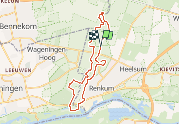
Tour Zu Fuß von 14,3 km verfügbar auf Geldern, Unbekannt, Renkum. Diese Tour wird von SityTrail - itinéraires balisés pédestres vorgeschlagen.
Beschreibung
Trail created by https://klompenpaden.nl/.
Ort
Land:
Netherlands
Region :
Geldern
Abteilung/Provinz :
Unbekannt
Kommune :
Renkum
Standort:
Unknown
Gehen Sie:(Dec)
Gehen Sie:(UTM)
687651 ; 5763783 (31U) N.
Kommentare
Touren in der Umgebung
![Tour Zu Fuß Renkum - Rondje Beekdal - Photo](https://media.geolcdn.com/t/375/260/7f45de1d-bdc1-4def-be6b-ac60cd7374f4.jpeg&format=jpg&maxdim=2)
![Zu Fuß Zu Fuß](https://static1.geolcdn.com/sitytour/trail-icons/100.png)
Rondje Beekdal
Zu Fuß
Einfach
Renkum,
Geldern,
Unbekannt,
Netherlands
![](/images/other/stat-length.png)
4,7 km | 5,6 km-effort
1h 16min
![](https://static1.geolcdn.com/siteimages/upload/files/16400158638029165_repeat_loop_refresh_sync_direction_icon.png)
Ja
![Tour Zu Fuß Ede - Buunderkamp - Rode pijl - Photo](https://media.geolcdn.com/t/375/260/968a0081-d191-41d7-a424-5be7a0106691.jpeg&format=jpg&maxdim=2)
![Zu Fuß Zu Fuß](https://static1.geolcdn.com/sitytour/trail-icons/100.png)
Buunderkamp - Rode pijl
Zu Fuß
Einfach
Ede,
Geldern,
Unbekannt,
Netherlands
![](/images/other/stat-length.png)
4,7 km | 5 km-effort
1h 8min
![](https://static1.geolcdn.com/siteimages/upload/files/16400158638029165_repeat_loop_refresh_sync_direction_icon.png)
Ja
![Tour Zu Fuß Wageningen - Wageningse Engpad - Photo](https://media.geolcdn.com/t/375/260/05e42583-2751-467e-af20-187bb32912a3.jpeg&format=jpg&maxdim=2)
![Zu Fuß Zu Fuß](https://static1.geolcdn.com/sitytour/trail-icons/100.png)
Wageningse Engpad
Zu Fuß
Einfach
Wageningen,
Geldern,
Unbekannt,
Netherlands
![](/images/other/stat-length.png)
12,5 km | 14,4 km-effort
3h 16min
![](https://static1.geolcdn.com/siteimages/upload/files/16400158638029165_repeat_loop_refresh_sync_direction_icon.png)
Ja
![Tour Zu Fuß Renkum - Molenbeeksepad - Photo](https://media.geolcdn.com/t/375/260/be8ca94d-f66a-461e-9184-fada35dc0854.jpeg&format=jpg&maxdim=2)
![Zu Fuß Zu Fuß](https://static1.geolcdn.com/sitytour/trail-icons/100.png)
Molenbeeksepad
Zu Fuß
Einfach
Renkum,
Geldern,
Unbekannt,
Netherlands
![](/images/other/stat-length.png)
16,4 km | 18,3 km-effort
4h 10min
![](https://static1.geolcdn.com/siteimages/upload/files/16400158638029165_repeat_loop_refresh_sync_direction_icon.png)
Ja
![Tour Zu Fuß Renkum - Nederrijnsepad - Photo](https://media.geolcdn.com/t/375/260/a4953e17-1ca9-4629-bde4-56e0bcb9361f.jpeg&format=jpg&maxdim=2)
![Zu Fuß Zu Fuß](https://static1.geolcdn.com/sitytour/trail-icons/100.png)
Nederrijnsepad
Zu Fuß
Einfach
Renkum,
Geldern,
Unbekannt,
Netherlands
![](/images/other/stat-length.png)
10,5 km | 11,7 km-effort
2h 39min
![](https://static1.geolcdn.com/siteimages/upload/files/16400158638029165_repeat_loop_refresh_sync_direction_icon.png)
Nein
![Tour Zu Fuß Ede - Oud Reemst - Geel - Photo](https://media.geolcdn.com/t/375/260/25466423-843d-4903-a4c1-99a07e86a578.jpeg&format=jpg&maxdim=2)
![Zu Fuß Zu Fuß](https://static1.geolcdn.com/sitytour/trail-icons/100.png)
Oud Reemst - Geel
Zu Fuß
Einfach
Ede,
Geldern,
Unbekannt,
Netherlands
![](/images/other/stat-length.png)
7,3 km | 8,1 km-effort
1h 50min
![](https://static1.geolcdn.com/siteimages/upload/files/16400158638029165_repeat_loop_refresh_sync_direction_icon.png)
Ja
![Tour Zu Fuß Ede - Welkom op de Sysselt! - Photo](https://media.geolcdn.com/t/375/260/cc4b5a33-943d-4108-95f6-d1e8f71175a8.jpeg&format=jpg&maxdim=2)
![Zu Fuß Zu Fuß](https://static1.geolcdn.com/sitytour/trail-icons/100.png)
Welkom op de Sysselt!
Zu Fuß
Einfach
Ede,
Geldern,
Unbekannt,
Netherlands
![](/images/other/stat-length.png)
4,5 km | 5,1 km-effort
1h 9min
![](https://static1.geolcdn.com/siteimages/upload/files/16400158638029165_repeat_loop_refresh_sync_direction_icon.png)
Ja
![Tour Zu Fuß Ede - Welkom op Hoekelum! - Photo](https://media.geolcdn.com/t/375/260/672e2f7a-b825-4566-8c62-177cc00a7bd5.jpeg&format=jpg&maxdim=2)
![Zu Fuß Zu Fuß](https://static1.geolcdn.com/sitytour/trail-icons/100.png)
Welkom op Hoekelum!
Zu Fuß
Einfach
Ede,
Geldern,
Unbekannt,
Netherlands
![](/images/other/stat-length.png)
3,7 km | 4,2 km-effort
57min
![](https://static1.geolcdn.com/siteimages/upload/files/16400158638029165_repeat_loop_refresh_sync_direction_icon.png)
Ja
![Tour Zu Fuß Renkum - Dunoroute - Photo](https://media.geolcdn.com/t/375/260/f687c97d-82cc-4f04-8a4a-6c6a3ea9dd10.jpeg&format=jpg&maxdim=2)
![Zu Fuß Zu Fuß](https://static1.geolcdn.com/sitytour/trail-icons/100.png)