![](/images/other/stat-length.png)
![Tour Zu Fuß Canencia - Senda del Arroyo del Sestil del Maíllo y de la Ladera de Mojonavalle - Photo](https://media.geolcdn.com/t/1900/400/f22f805a-f104-4f57-ac21-062d0d0b219f.jpeg&format=pjpeg&maxdim=2)
Senda del Arroyo del Sestil del Maíllo y de la Ladera de Mojonavalle
SityTrail - itinéraires balisés pédestres
Tous les sentiers balisés d’Europe GUIDE+
![Länge](/images/other/stat-length.png)
Länge
7,5 km
![Maximale Höhe](https://static1.geolcdn.com/siteimages/upload/files/1508320355ic_sort_altitude_max_24dp.png)
Maximale Höhe
1596 m
![Positive Höhendifferenz](https://static1.geolcdn.com/siteimages/upload/files/1508320355ic_sort_den_pos_24dp.png)
Positive Höhendifferenz
255 m
![Km-Effort](/images/other/stat-length.png)
Km-Effort
10,9 km
![Min. Höhe](https://static1.geolcdn.com/siteimages/upload/files/1508320355ic_sort_altitude_min_24dp.png)
Min. Höhe
1421 m
![Negative Höhendifferenz](https://static1.geolcdn.com/siteimages/upload/files/1508320355ic_sort_den_neg_24dp.png)
Negative Höhendifferenz
258 m
![Boucle](https://static1.geolcdn.com/siteimages/upload/files/16400158638029165_repeat_loop_refresh_sync_direction_icon.png)
Boucle
Ja
Kennzeichnung
Erstellungsdatum :
2022-02-14 15:53:03.481
Letzte Änderung :
2022-02-14 15:53:03.481
![Zu Fuß](https://static1.geolcdn.com/sitytour/trail-icons/100.png)
2h28
Schwierigkeit : Einfach
![Scannen Sie diesen QR-Code, um die Tour in der SityTrail-Anwendung zu öffnen](https://capi.geolives.com/qq0zvz2zws4bq2lad0pu/sitytour/trails/3110878/qr.png?size=200)
Kostenlosegpshiking-Anwendung
Über SityTrail
Tour Zu Fuß von 7,5 km verfügbar auf Autonome Gemeinschaft Madrid, Unbekannt, Canencia. Diese Tour wird von SityTrail - itinéraires balisés pédestres vorgeschlagen.
Beschreibung
Ort
Land:
Spain
Region :
Autonome Gemeinschaft Madrid
Abteilung/Provinz :
Unbekannt
Kommune :
Canencia
Standort:
Unknown
Gehen Sie:(Dec)
Gehen Sie:(UTM)
434889 ; 4524887 (30T) N.
Kommentare
Touren in der Umgebung
![Tour Zu Fuß Manzanares el Real - [RV 22] Garganta de la Camorza - Photo](https://media.geolcdn.com/t/375/260/90bbe6fd-f585-4379-a530-b8909ea4cd65.jpeg&format=jpg&maxdim=2)
![Zu Fuß Zu Fuß](https://static1.geolcdn.com/sitytour/trail-icons/100.png)
[RV 22] Garganta de la Camorza
Zu Fuß
Einfach
Manzanares el Real,
Autonome Gemeinschaft Madrid,
Unbekannt,
Spain
![](/images/other/stat-length.png)
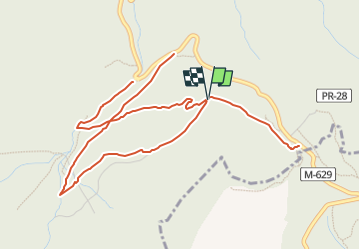
5,5 km | 7 km-effort
1h 35min
![](https://static1.geolcdn.com/siteimages/upload/files/16400158638029165_repeat_loop_refresh_sync_direction_icon.png)
Nein
![Tour Zu Fuß Manzanares el Real - [RV 20] Collado de la Dehesilla - Photo](https://media.geolcdn.com/t/375/260/14f6a6c8-b3ec-4ba1-b1d6-fe22cff41c84.jpeg&format=jpg&maxdim=2)
![Zu Fuß Zu Fuß](https://static1.geolcdn.com/sitytour/trail-icons/100.png)
[RV 20] Collado de la Dehesilla
Zu Fuß
Einfach
Manzanares el Real,
Autonome Gemeinschaft Madrid,
Unbekannt,
Spain
![](/images/other/stat-length.png)
3,9 km | 8 km-effort
1h 48min
![](https://static1.geolcdn.com/siteimages/upload/files/16400158638029165_repeat_loop_refresh_sync_direction_icon.png)
Nein
![Tour Zu Fuß Manzanares el Real - [RV 21] Circular Collado Cabrón - Photo](https://media.geolcdn.com/t/375/260/08dd2715-3a1e-44a0-9842-91629ab6f415.jpeg&format=jpg&maxdim=2)
![Zu Fuß Zu Fuß](https://static1.geolcdn.com/sitytour/trail-icons/100.png)
[RV 21] Circular Collado Cabrón
Zu Fuß
Einfach
Manzanares el Real,
Autonome Gemeinschaft Madrid,
Unbekannt,
Spain
![](/images/other/stat-length.png)
5,4 km | 8,9 km-effort
2h 1min
![](https://static1.geolcdn.com/siteimages/upload/files/16400158638029165_repeat_loop_refresh_sync_direction_icon.png)
Ja
![Tour Zu Fuß Garganta de los Montes - ES-PR-29 - Photo](https://media.geolcdn.com/t/375/260/d05d637c-a197-48c4-9a9c-3f28707573a8.jpeg&format=jpg&maxdim=2)
![Zu Fuß Zu Fuß](https://static1.geolcdn.com/sitytour/trail-icons/100.png)
ES-PR-29
Zu Fuß
Medium
Garganta de los Montes,
Autonome Gemeinschaft Madrid,
Unbekannt,
Spain
![](/images/other/stat-length.png)
21 km | 27 km-effort
6h 12min
![](https://static1.geolcdn.com/siteimages/upload/files/16400158638029165_repeat_loop_refresh_sync_direction_icon.png)
Ja
![Tour Zu Fuß Manzanares el Real - [RV 23] Collado Quebrantahuesos - Photo](https://media.geolcdn.com/t/375/260/52736da5-4c36-4bd1-8ff5-641fc5706541.jpeg&format=jpg&maxdim=2)
![Zu Fuß Zu Fuß](https://static1.geolcdn.com/sitytour/trail-icons/100.png)
[RV 23] Collado Quebrantahuesos
Zu Fuß
Einfach
Manzanares el Real,
Autonome Gemeinschaft Madrid,
Unbekannt,
Spain
![](/images/other/stat-length.png)
3,9 km | 6,1 km-effort
1h 22min
![](https://static1.geolcdn.com/siteimages/upload/files/16400158638029165_repeat_loop_refresh_sync_direction_icon.png)
Nein
![Tour Zu Fuß Rascafría - [RV 5.2] Mirador de los Robledos - Photo](https://media.geolcdn.com/t/375/260/832bcf1e-0c3e-4069-9b8e-00ba1134c549.jpeg&format=jpg&maxdim=2)
![Zu Fuß Zu Fuß](https://static1.geolcdn.com/sitytour/trail-icons/100.png)
[RV 5.2] Mirador de los Robledos
Zu Fuß
Einfach
Rascafría,
Autonome Gemeinschaft Madrid,
Unbekannt,
Spain
![](/images/other/stat-length.png)
6,6 km | 8,9 km-effort
2h 1min
![](https://static1.geolcdn.com/siteimages/upload/files/16400158638029165_repeat_loop_refresh_sync_direction_icon.png)
Nein
![Tour Zu Fuß Rascafría - [RV 1.1] Camino del Ejido - Photo](https://media.geolcdn.com/t/375/260/f9f079e9-0b81-4f1d-9a2e-9296fff2ffa1.jpeg&format=jpg&maxdim=2)
![Zu Fuß Zu Fuß](https://static1.geolcdn.com/sitytour/trail-icons/100.png)
[RV 1.1] Camino del Ejido
Zu Fuß
Einfach
Rascafría,
Autonome Gemeinschaft Madrid,
Unbekannt,
Spain
![](/images/other/stat-length.png)
4,8 km | 5,2 km-effort
1h 10min
![](https://static1.geolcdn.com/siteimages/upload/files/16400158638029165_repeat_loop_refresh_sync_direction_icon.png)
Nein
![Tour Zu Fuß Rascafría - [RV 4] Puerto del Reventón - Photo](https://media.geolcdn.com/t/375/260/f9f079e9-0b81-4f1d-9a2e-9296fff2ffa1.jpeg&format=jpg&maxdim=2)
![Zu Fuß Zu Fuß](https://static1.geolcdn.com/sitytour/trail-icons/100.png)
[RV 4] Puerto del Reventón
Zu Fuß
Medium
Rascafría,
Autonome Gemeinschaft Madrid,
Unbekannt,
Spain
![](/images/other/stat-length.png)
11,8 km | 21 km-effort
4h 44min
![](https://static1.geolcdn.com/siteimages/upload/files/16400158638029165_repeat_loop_refresh_sync_direction_icon.png)
Nein
![Tour Zu Fuß Rascafría - [RV 1] Presa del Pradillo - Photo](https://media.geolcdn.com/t/375/260/cfb42bfb-3ed6-497a-a24b-dc87b1356993.jpeg&format=jpg&maxdim=2)
![Zu Fuß Zu Fuß](https://static1.geolcdn.com/sitytour/trail-icons/100.png)
[RV 1] Presa del Pradillo
Zu Fuß
Medium
Rascafría,
Autonome Gemeinschaft Madrid,
Unbekannt,
Spain
![](/images/other/stat-length.png)
16,4 km | 24 km-effort
5h 33min
![](https://static1.geolcdn.com/siteimages/upload/files/16400158638029165_repeat_loop_refresh_sync_direction_icon.png)
Nein