


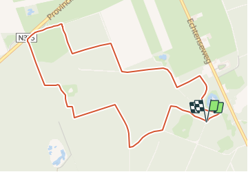

4,2 km | 4,4 km-effort

Tous les sentiers balisés d’Europe GUIDE+


Kostenlosegpshiking-Anwendung
 SityTrail
IGN / Geografische Institute
SityTrail World
Die Welt öffnet sich für Sie
Tour Zu Fuß von 5 km verfügbar auf Drente, Unbekannt, De Wolden. Diese Tour wird von SityTrail - itinéraires balisés pédestres vorgeschlagen.
Symbol: Hiker on a blue square


Zu Fuß
Zu Fuß
Zu Fuß
Zu Fuß

Fahrrad
Mountainbike
Mountainbike

Wandern
Wandern