![](/images/other/stat-length.png)
![Tour Zu Fuß Burgos - Paseos por el Cinturón Verde: El Patillo - Photo](https://media.geolcdn.com/t/1900/400/ext.pjpeg?maxdim=2&url=https%3A%2F%2Fstatic1.geolcdn.com%2Fsiteimages%2Fupload%2Ffiles%2F1545311037marcheuse_200dpi.jpg)
Paseos por el Cinturón Verde: El Patillo
SityTrail - itinéraires balisés pédestres
Tous les sentiers balisés d’Europe GUIDE+
![Länge](/images/other/stat-length.png)
Länge
3,6 km
![Maximale Höhe](https://static1.geolcdn.com/siteimages/upload/files/1508320355ic_sort_altitude_max_24dp.png)
Maximale Höhe
932 m
![Positive Höhendifferenz](https://static1.geolcdn.com/siteimages/upload/files/1508320355ic_sort_den_pos_24dp.png)
Positive Höhendifferenz
104 m
![Km-Effort](/images/other/stat-length.png)
Km-Effort
4,9 km
![Min. Höhe](https://static1.geolcdn.com/siteimages/upload/files/1508320355ic_sort_altitude_min_24dp.png)
Min. Höhe
828 m
![Negative Höhendifferenz](https://static1.geolcdn.com/siteimages/upload/files/1508320355ic_sort_den_neg_24dp.png)
Negative Höhendifferenz
62 m
![Boucle](https://static1.geolcdn.com/siteimages/upload/files/16400158638029165_repeat_loop_refresh_sync_direction_icon.png)
Boucle
Nein
Kennzeichnung
Erstellungsdatum :
2022-02-14 15:35:32.955
Letzte Änderung :
2022-02-14 15:35:32.955
![Zu Fuß](https://static1.geolcdn.com/sitytour/trail-icons/100.png)
1h06
Schwierigkeit : Einfach
![Scannen Sie diesen QR-Code, um die Tour in der SityTrail-Anwendung zu öffnen](https://capi.geolives.com/qq0zvz2zws4bq2lad0pu/sitytour/trails/3110373/qr.png?size=200)
Kostenlosegpshiking-Anwendung
Über SityTrail
Tour Zu Fuß von 3,6 km verfügbar auf Kastilien und León, Burgos, Burgos. Diese Tour wird von SityTrail - itinéraires balisés pédestres vorgeschlagen.
Beschreibung
Trail created by Ayuntamiento de Burgos.
Website: http://www.aytoburgos.es/medio-ambiente/cinturon-verde-de-burgos/senderos/guia-de-paseos-por-el-cinturon-verde
Ort
Land:
Spain
Region :
Kastilien und León
Abteilung/Provinz :
Burgos
Kommune :
Burgos
Standort:
Unknown
Gehen Sie:(Dec)
Gehen Sie:(UTM)
436218 ; 4690182 (30T) N.
Kommentare
Touren in der Umgebung
![Tour Zu Fuß Burgos - Paseos por el Cinturón Verde: La Lora - Cerro de la Galga - Photo](https://media.geolcdn.com/t/375/260/92fe05fc-7cca-45d8-b5d9-2b8e6f7fa533.jpeg&format=jpg&maxdim=2)
![Zu Fuß Zu Fuß](https://static1.geolcdn.com/sitytour/trail-icons/100.png)
Paseos por el Cinturón Verde: La Lora - Cerro de la Galga
Zu Fuß
Einfach
Burgos,
Kastilien und León,
Burgos,
Spain
![](/images/other/stat-length.png)
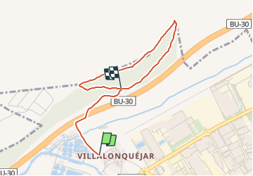
4,9 km | 6,3 km-effort
1h 25min
![](https://static1.geolcdn.com/siteimages/upload/files/16400158638029165_repeat_loop_refresh_sync_direction_icon.png)
Nein
![Tour Zu Fuß Burgos - Paseos por el Cinturón Verde: Fábrica de la Moneda y Timbre - Barrio de Villalonquéjar - Photo](https://media.geolcdn.com/t/375/260/16393599-a383-4eb0-b1fc-4fb2608e1bec.jpeg&format=jpg&maxdim=2)
![Zu Fuß Zu Fuß](https://static1.geolcdn.com/sitytour/trail-icons/100.png)
Paseos por el Cinturón Verde: Fábrica de la Moneda y Timbre - Barrio de Villa...
Zu Fuß
Einfach
Burgos,
Kastilien und León,
Burgos,
Spain
![](/images/other/stat-length.png)
9,2 km | 10 km-effort
2h 15min
![](https://static1.geolcdn.com/siteimages/upload/files/16400158638029165_repeat_loop_refresh_sync_direction_icon.png)
Ja
![Tour Zu Fuß Burgos - Los caminos del agua siguiendo el Arlanzón - Photo](https://media.geolcdn.com/t/375/260/3d0b8cc9-8bb3-4b91-ba1c-09224488703a.jpeg&format=jpg&maxdim=2)
![Zu Fuß Zu Fuß](https://static1.geolcdn.com/sitytour/trail-icons/100.png)
Los caminos del agua siguiendo el Arlanzón
Zu Fuß
Einfach
Burgos,
Kastilien und León,
Burgos,
Spain
![](/images/other/stat-length.png)
5,6 km | 6,5 km-effort
1h 28min
![](https://static1.geolcdn.com/siteimages/upload/files/16400158638029165_repeat_loop_refresh_sync_direction_icon.png)
Nein
![Tour Wandern Tardajos - 2023 14 hontanas - Photo](https://media.geolcdn.com/t/375/260/fade5700-e6a2-40be-af32-ad73e261c2aa.jpg&format=jpg&maxdim=2)
![Wandern Wandern](https://static1.geolcdn.com/sitytour/trail-icons/101.png)
2023 14 hontanas
Wandern
Einfach
Tardajos,
Kastilien und León,
Unbekannt,
Spain
![](/images/other/stat-length.png)
21 km | 25 km-effort
6h 1min
![](https://static1.geolcdn.com/siteimages/upload/files/16400158638029165_repeat_loop_refresh_sync_direction_icon.png)
Nein
![Tour Wandern Tardajos - Compostelle - Camino Frances : J12 de Tardajos à Castrojeriz - Photo](https://media.geolcdn.com/t/375/260/ext.jpg?maxdim=2&url=https%3A%2F%2Fstatic1.geolcdn.com%2Fsiteimages%2Fupload%2Ffiles%2F1553511878bg_sport_marche.png)
![Wandern Wandern](https://static1.geolcdn.com/sitytour/trail-icons/101.png)
Compostelle - Camino Frances : J12 de Tardajos à Castrojeriz
Wandern
Medium
Tardajos,
Kastilien und León,
Unbekannt,
Spain
![](/images/other/stat-length.png)
29 km | 34 km-effort
9h 7min
![](https://static1.geolcdn.com/siteimages/upload/files/16400158638029165_repeat_loop_refresh_sync_direction_icon.png)
Nein
![Tour Wandern Burgos - 1 camino hornillos - Photo](https://media.geolcdn.com/t/375/260/ext.jpg?maxdim=2&url=https%3A%2F%2Fstatic1.geolcdn.com%2Fsiteimages%2Fupload%2Ffiles%2F1553511878bg_sport_marche.png)
![Wandern Wandern](https://static1.geolcdn.com/sitytour/trail-icons/101.png)
1 camino hornillos
Wandern
Sehr leicht
Burgos,
Kastilien und León,
Burgos,
Spain
![](/images/other/stat-length.png)
18,8 km | 21 km-effort
3h 30min
![](https://static1.geolcdn.com/siteimages/upload/files/16400158638029165_repeat_loop_refresh_sync_direction_icon.png)
Nein