![](/images/other/stat-length.png)
![Tour Zu Fuß Zütphen - Leestensche Broekpad (Klompenpad) - Photo](https://media.geolcdn.com/t/1900/400/44e3f8db-a211-4e70-b435-60081fcd3243.jpeg&format=pjpeg&maxdim=2)
Leestensche Broekpad (Klompenpad)
SityTrail - itinéraires balisés pédestres
Tous les sentiers balisés d’Europe GUIDE+
![Länge](/images/other/stat-length.png)
Länge
11,7 km
![Maximale Höhe](https://static1.geolcdn.com/siteimages/upload/files/1508320355ic_sort_altitude_max_24dp.png)
Maximale Höhe
23 m
![Positive Höhendifferenz](https://static1.geolcdn.com/siteimages/upload/files/1508320355ic_sort_den_pos_24dp.png)
Positive Höhendifferenz
64 m
![Km-Effort](/images/other/stat-length.png)
Km-Effort
12,6 km
![Min. Höhe](https://static1.geolcdn.com/siteimages/upload/files/1508320355ic_sort_altitude_min_24dp.png)
Min. Höhe
4 m
![Negative Höhendifferenz](https://static1.geolcdn.com/siteimages/upload/files/1508320355ic_sort_den_neg_24dp.png)
Negative Höhendifferenz
64 m
![Boucle](https://static1.geolcdn.com/siteimages/upload/files/16400158638029165_repeat_loop_refresh_sync_direction_icon.png)
Boucle
Ja
Kennzeichnung
Erstellungsdatum :
2022-02-14 15:01:42.919
Letzte Änderung :
2022-02-14 15:01:42.919
![Zu Fuß](https://static1.geolcdn.com/sitytour/trail-icons/100.png)
2h51
Schwierigkeit : Einfach
![Scannen Sie diesen QR-Code, um die Tour in der SityTrail-Anwendung zu öffnen](https://capi.geolives.com/qq0zvz2zws4bq2lad0pu/sitytour/trails/3109484/qr.png?size=200)
Kostenlosegpshiking-Anwendung
Über SityTrail
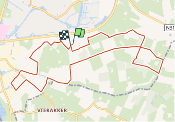
Tour Zu Fuß von 11,7 km verfügbar auf Geldern, Unbekannt, Zütphen. Diese Tour wird von SityTrail - itinéraires balisés pédestres vorgeschlagen.
Beschreibung
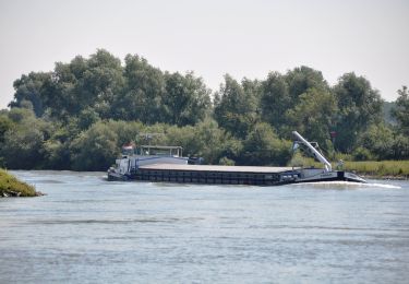
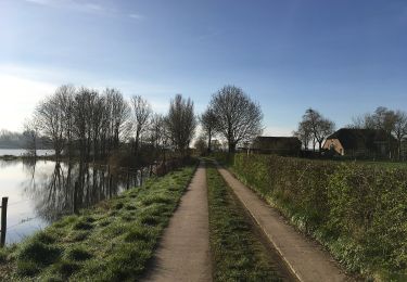
Wandelen langs laken, over boerenland en langs de rivier in het mooie buitengebied van Zutphen.
Website: http://klompenpaden.nl/klompenpad/leestensche-broekpad/
Ort
Land:
Netherlands
Region :
Geldern
Abteilung/Provinz :
Unbekannt
Kommune :
Zütphen
Standort:
Unknown
Gehen Sie:(Dec)
Gehen Sie:(UTM)
311264 ; 5778139 (32U) N.
Kommentare
Touren in der Umgebung
![Tour Zu Fuß Bronckhorst - Hackfortse Enkroute - Photo](https://media.geolcdn.com/t/375/260/40f9f402-e097-413d-87d3-c98c81a339fc.jpeg&format=jpg&maxdim=2)
![Zu Fuß Zu Fuß](https://static1.geolcdn.com/sitytour/trail-icons/100.png)
Hackfortse Enkroute
Zu Fuß
Einfach
Bronckhorst,
Geldern,
Unbekannt,
Netherlands
![](/images/other/stat-length.png)
16,5 km | 18 km-effort
4h 5min
![](https://static1.geolcdn.com/siteimages/upload/files/16400158638029165_repeat_loop_refresh_sync_direction_icon.png)
Ja
![Tour Zu Fuß Lochem - Rondje Almen - Photo](https://media.geolcdn.com/t/375/260/9448f3cc-3218-4985-8aea-1eaf9a59cd1e.jpeg&format=jpg&maxdim=2)
![Zu Fuß Zu Fuß](https://static1.geolcdn.com/sitytour/trail-icons/100.png)
Rondje Almen
Zu Fuß
Einfach
Lochem,
Geldern,
Unbekannt,
Netherlands
![](/images/other/stat-length.png)
4,6 km | 4,8 km-effort
1h 5min
![](https://static1.geolcdn.com/siteimages/upload/files/16400158638029165_repeat_loop_refresh_sync_direction_icon.png)
Ja
![Tour Zu Fuß Lochem - Rondje Twentekanaal - Photo](https://media.geolcdn.com/t/375/260/9ce72cfc-4f01-405e-8354-54a0e629964d.jpeg&format=jpg&maxdim=2)
![Zu Fuß Zu Fuß](https://static1.geolcdn.com/sitytour/trail-icons/100.png)
Rondje Twentekanaal
Zu Fuß
Einfach
Lochem,
Geldern,
Unbekannt,
Netherlands
![](/images/other/stat-length.png)
11,8 km | 13,1 km-effort
2h 59min
![](https://static1.geolcdn.com/siteimages/upload/files/16400158638029165_repeat_loop_refresh_sync_direction_icon.png)
Ja
![Tour Zu Fuß Brummen - NL-Extension of NS-Wandeltocht Uiterwaarden van Cortenoever - Photo](https://media.geolcdn.com/t/375/260/93a9c4c6-7c78-4551-a6c2-3d1579e46df8.jpeg&format=jpg&maxdim=2)
![Zu Fuß Zu Fuß](https://static1.geolcdn.com/sitytour/trail-icons/100.png)
NL-Extension of NS-Wandeltocht Uiterwaarden van Cortenoever
Zu Fuß
Einfach
Brummen,
Geldern,
Unbekannt,
Netherlands
![](/images/other/stat-length.png)
3,1 km | 3,2 km-effort
44min
![](https://static1.geolcdn.com/siteimages/upload/files/16400158638029165_repeat_loop_refresh_sync_direction_icon.png)
Nein
![Tour Zu Fuß Lochem - Onderlaatsche Laakroute - Photo](https://media.geolcdn.com/t/375/260/0c1a3f46-6d65-476b-aa36-984711d78f86.jpeg&format=jpg&maxdim=2)
![Zu Fuß Zu Fuß](https://static1.geolcdn.com/sitytour/trail-icons/100.png)
Onderlaatsche Laakroute
Zu Fuß
Einfach
Lochem,
Geldern,
Unbekannt,
Netherlands
![](/images/other/stat-length.png)
5,9 km | 6,5 km-effort
1h 28min
![](https://static1.geolcdn.com/siteimages/upload/files/16400158638029165_repeat_loop_refresh_sync_direction_icon.png)
Ja
![Tour Zu Fuß Zütphen - NS-Wandeling IJsselvallei - Photo](https://media.geolcdn.com/t/375/260/dda9cbdd-77d1-4a70-b18d-18aec91275a3.jpeg&format=jpg&maxdim=2)
![Zu Fuß Zu Fuß](https://static1.geolcdn.com/sitytour/trail-icons/100.png)
NS-Wandeling IJsselvallei
Zu Fuß
Schwierig
Zütphen,
Geldern,
Unbekannt,
Netherlands
![](/images/other/stat-length.png)
32 km | 35 km-effort
7h 59min
![](https://static1.geolcdn.com/siteimages/upload/files/16400158638029165_repeat_loop_refresh_sync_direction_icon.png)
Nein
![Tour Zu Fuß Bronckhorst - Ockhorstroute - Photo](https://media.geolcdn.com/t/375/260/6cd8504f-9b6a-4dbb-968b-06c70e52fa7b.jpeg&format=jpg&maxdim=2)
![Zu Fuß Zu Fuß](https://static1.geolcdn.com/sitytour/trail-icons/100.png)
Ockhorstroute
Zu Fuß
Einfach
Bronckhorst,
Geldern,
Unbekannt,
Netherlands
![](/images/other/stat-length.png)
7,7 km | 8,4 km-effort
1h 54min
![](https://static1.geolcdn.com/siteimages/upload/files/16400158638029165_repeat_loop_refresh_sync_direction_icon.png)
Ja
![Tour Zu Fuß Lochem - Berkelvalleiroute - Photo](https://media.geolcdn.com/t/375/260/9ce72cfc-4f01-405e-8354-54a0e629964d.jpeg&format=jpg&maxdim=2)
![Zu Fuß Zu Fuß](https://static1.geolcdn.com/sitytour/trail-icons/100.png)
Berkelvalleiroute
Zu Fuß
Medium
Lochem,
Geldern,
Unbekannt,
Netherlands
![](/images/other/stat-length.png)
18,1 km | 20 km-effort
4h 33min
![](https://static1.geolcdn.com/siteimages/upload/files/16400158638029165_repeat_loop_refresh_sync_direction_icon.png)
Ja
![Tour Zu Fuß Lochem - Berkel route - Photo](https://media.geolcdn.com/t/375/260/9ce72cfc-4f01-405e-8354-54a0e629964d.jpeg&format=jpg&maxdim=2)
![Zu Fuß Zu Fuß](https://static1.geolcdn.com/sitytour/trail-icons/100.png)
Berkel route
Zu Fuß
Einfach
Lochem,
Geldern,
Unbekannt,
Netherlands
![](/images/other/stat-length.png)
7,2 km | 7,8 km-effort
1h 46min
![](https://static1.geolcdn.com/siteimages/upload/files/16400158638029165_repeat_loop_refresh_sync_direction_icon.png)
Ja