![](/images/other/stat-length.png)
![Tour Zu Fuß Antas - Casa Azenha Branca Trilho das Azenhas das Antas - Photo](https://media.geolcdn.com/t/1900/400/ext.pjpeg?maxdim=2&url=https%3A%2F%2Fmedia.geolcdn.com%2Ff%2Fdca20f23-8fe5-4cf1-a2cd-c4136ea4587c.jpeg)
Casa Azenha Branca Trilho das Azenhas das Antas
SityTrail - itinéraires balisés pédestres
Tous les sentiers balisés d’Europe PRO
![Länge](/images/other/stat-length.png)
Länge
11,4 km
![Maximale Höhe](https://static1.geolcdn.com/siteimages/upload/files/1508320355ic_sort_altitude_max_24dp.png)
Maximale Höhe
115 m
![Positive Höhendifferenz](https://static1.geolcdn.com/siteimages/upload/files/1508320355ic_sort_den_pos_24dp.png)
Positive Höhendifferenz
217 m
![Km-Effort](/images/other/stat-length.png)
Km-Effort
14,3 km
![Min. Höhe](https://static1.geolcdn.com/siteimages/upload/files/1508320355ic_sort_altitude_min_24dp.png)
Min. Höhe
5 m
![Negative Höhendifferenz](https://static1.geolcdn.com/siteimages/upload/files/1508320355ic_sort_den_neg_24dp.png)
Negative Höhendifferenz
212 m
![Boucle](https://static1.geolcdn.com/siteimages/upload/files/16400158638029165_repeat_loop_refresh_sync_direction_icon.png)
Boucle
Ja
Kennzeichnung
Erstellungsdatum :
2022-02-14 14:53:18.219
Letzte Änderung :
2022-02-14 14:53:18.219
![Zu Fuß](https://static1.geolcdn.com/sitytour/trail-icons/100.png)
3h15
Schwierigkeit : Einfach
![Scannen Sie diesen QR-Code, um die Tour in der SityTrail-Anwendung zu öffnen](https://capi.geolives.com/qq0zvz2zws4bq2lad0pu/sitytour/trails/3109369/qr.png?size=200)
Kostenlosegpshiking-Anwendung
Über SityTrail
Tour Zu Fuß von 11,4 km verfügbar auf Nord, Braga, Antas. Diese Tour wird von SityTrail - itinéraires balisés pédestres vorgeschlagen.
Beschreibung
Website: https://www.visitesposende.com/pt/fazer/percursos/pr4-trilho-das-azenhas-das-antas
Ort
Land:
Portugal
Region :
Nord
Abteilung/Provinz :
Braga
Kommune :
Antas
Standort:
Unknown
Gehen Sie:(Dec)
Gehen Sie:(UTM)
518586 ; 4606885 (29T) N.
Kommentare
Touren in der Umgebung
![Tour Zu Fuß Antas - Caminhos da Fé - Belinho - Photo](https://media.geolcdn.com/t/375/260/ext.jpg?maxdim=2&url=https%3A%2F%2Fmedia.geolcdn.com%2Ff%2Fe975be8a-06a3-4a04-a541-6c786e95c32d.jpeg)
![Zu Fuß Zu Fuß](https://static1.geolcdn.com/sitytour/trail-icons/100.png)
Caminhos da Fé - Belinho
Zu Fuß
Einfach
Antas,
Nord,
Braga,
Portugal
![](/images/other/stat-length.png)
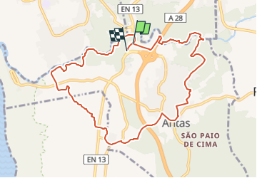
4,1 km | 5,4 km-effort
1h 14min
![](https://static1.geolcdn.com/siteimages/upload/files/16400158638029165_repeat_loop_refresh_sync_direction_icon.png)
Nein
![Tour Zu Fuß Antas - Trilho das Cangostas - Photo](https://media.geolcdn.com/t/375/260/ext.jpg?maxdim=2&url=https%3A%2F%2Fmedia.geolcdn.com%2Ff%2Fa14ed07d-95eb-4fdc-8b2b-a09d89b9c85b.jpeg)
![Zu Fuß Zu Fuß](https://static1.geolcdn.com/sitytour/trail-icons/100.png)
Trilho das Cangostas
Zu Fuß
Einfach
Antas,
Nord,
Braga,
Portugal
![](/images/other/stat-length.png)
9 km | 12,2 km-effort
2h 46min
![](https://static1.geolcdn.com/siteimages/upload/files/16400158638029165_repeat_loop_refresh_sync_direction_icon.png)
Nein
![Tour Zu Fuß Antas - Entre o Neiva e o Atlântico - Photo](https://media.geolcdn.com/t/375/260/ext.jpg?maxdim=2&url=https%3A%2F%2Fmedia.geolcdn.com%2Ff%2Fb69d3f32-6740-433b-9f17-d978825cbaa4.jpeg)
![Zu Fuß Zu Fuß](https://static1.geolcdn.com/sitytour/trail-icons/100.png)
Entre o Neiva e o Atlântico
Zu Fuß
Einfach
Antas,
Nord,
Braga,
Portugal
![](/images/other/stat-length.png)
8,7 km | 9,5 km-effort
2h 9min
![](https://static1.geolcdn.com/siteimages/upload/files/16400158638029165_repeat_loop_refresh_sync_direction_icon.png)
Ja
![Tour Zu Fuß Forjães - Margens do Neiva - Photo](https://media.geolcdn.com/t/375/260/ext.jpg?maxdim=2&url=https%3A%2F%2Fstatic1.geolcdn.com%2Fsiteimages%2Fupload%2Ffiles%2F1545311037marcheuse_200dpi.jpg)
![Zu Fuß Zu Fuß](https://static1.geolcdn.com/sitytour/trail-icons/100.png)