![](/images/other/stat-length.png)
![Tour Zu Fuß Tegueste - SL-TG 03 Las Canteras-Las Toscas - Photo](https://media.geolcdn.com/t/1900/400/9b02a4e1-6549-4943-9eb8-9ef13f2363ff.jpeg&format=pjpeg&maxdim=2)
SL-TG 03 Las Canteras-Las Toscas
SityTrail - itinéraires balisés pédestres
Tous les sentiers balisés d’Europe GUIDE+
![Länge](/images/other/stat-length.png)
Länge
6,4 km
![Maximale Höhe](https://static1.geolcdn.com/siteimages/upload/files/1508320355ic_sort_altitude_max_24dp.png)
Maximale Höhe
601 m
![Positive Höhendifferenz](https://static1.geolcdn.com/siteimages/upload/files/1508320355ic_sort_den_pos_24dp.png)
Positive Höhendifferenz
335 m
![Km-Effort](/images/other/stat-length.png)
Km-Effort
9,8 km
![Min. Höhe](https://static1.geolcdn.com/siteimages/upload/files/1508320355ic_sort_altitude_min_24dp.png)
Min. Höhe
285 m
![Negative Höhendifferenz](https://static1.geolcdn.com/siteimages/upload/files/1508320355ic_sort_den_neg_24dp.png)
Negative Höhendifferenz
23 m
![Boucle](https://static1.geolcdn.com/siteimages/upload/files/16400158638029165_repeat_loop_refresh_sync_direction_icon.png)
Boucle
Nein
Kennzeichnung
Erstellungsdatum :
2022-02-14 14:40:32.023
Letzte Änderung :
2022-02-14 14:40:32.023
![Zu Fuß](https://static1.geolcdn.com/sitytour/trail-icons/100.png)
2h13
Schwierigkeit : Einfach
![Scannen Sie diesen QR-Code, um die Tour in der SityTrail-Anwendung zu öffnen](https://capi.geolives.com/qq0zvz2zws4bq2lad0pu/sitytour/trails/3109058/qr.png?size=200)
Kostenlosegpshiking-Anwendung
Über SityTrail
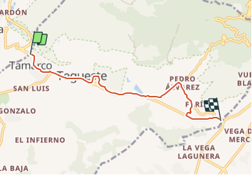
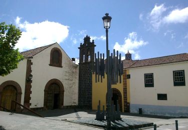
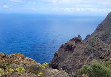
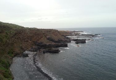
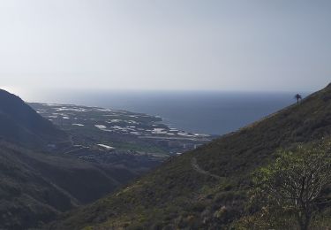
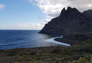
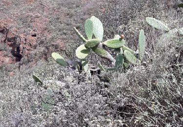
Tour Zu Fuß von 6,4 km verfügbar auf Kanarische Inseln, Santa Cruz de Tenerife, Tegueste. Diese Tour wird von SityTrail - itinéraires balisés pédestres vorgeschlagen.
Beschreibung
Trail created by Ayuntamiento de Tegueste.
Symbol: parallel horizontal bars green white
Ort
Land:
Spain
Region :
Kanarische Inseln
Abteilung/Provinz :
Santa Cruz de Tenerife
Kommune :
Tegueste
Standort:
Unknown
Gehen Sie:(Dec)
Gehen Sie:(UTM)
367586 ; 3156423 (28R) N.
Kommentare
Touren in der Umgebung
![Tour Zu Fuß San Cristóbal de La Laguna - ES-SL-TG 01 Tegueste-Bajamar - Photo](https://media.geolcdn.com/t/375/260/65f44273-f2cc-400e-98ab-6e6e24660cd8.jpeg&format=jpg&maxdim=2)
![Zu Fuß Zu Fuß](https://static1.geolcdn.com/sitytour/trail-icons/100.png)
ES-SL-TG 01 Tegueste-Bajamar
Zu Fuß
Einfach
San Cristóbal de La Laguna,
Kanarische Inseln,
Santa Cruz de Tenerife,
Spain
![](/images/other/stat-length.png)
8,9 km | 17,5 km-effort
3h 59min
![](https://static1.geolcdn.com/siteimages/upload/files/16400158638029165_repeat_loop_refresh_sync_direction_icon.png)
Nein
![Tour Zu Fuß San Cristóbal de La Laguna - SL-TG 02 El Portezuelo-El Socorro - Photo](https://media.geolcdn.com/t/375/260/439141b9-9225-42e5-aa29-a8f38c84a55c.jpeg&format=jpg&maxdim=2)
![Zu Fuß Zu Fuß](https://static1.geolcdn.com/sitytour/trail-icons/100.png)
SL-TG 02 El Portezuelo-El Socorro
Zu Fuß
Einfach
San Cristóbal de La Laguna,
Kanarische Inseln,
Santa Cruz de Tenerife,
Spain
![](/images/other/stat-length.png)
5,8 km | 7,8 km-effort
1h 46min
![](https://static1.geolcdn.com/siteimages/upload/files/16400158638029165_repeat_loop_refresh_sync_direction_icon.png)
Nein
![Tour Zu Fuß San Cristóbal de La Laguna - Camino de Candelaria de Tegueste - Photo](https://media.geolcdn.com/t/375/260/be0e3d77-69cd-4aea-addd-378ac79d031e.jpeg&format=jpg&maxdim=2)
![Zu Fuß Zu Fuß](https://static1.geolcdn.com/sitytour/trail-icons/100.png)
Camino de Candelaria de Tegueste
Zu Fuß
Einfach
San Cristóbal de La Laguna,
Kanarische Inseln,
Santa Cruz de Tenerife,
Spain
![](/images/other/stat-length.png)
5 km | 7,5 km-effort
1h 41min
![](https://static1.geolcdn.com/siteimages/upload/files/16400158638029165_repeat_loop_refresh_sync_direction_icon.png)
Nein
![Tour Zu Fuß San Cristóbal de La Laguna - Camino de Candelaria de La Laguna - Photo](https://media.geolcdn.com/t/375/260/46a6c584-6b34-413d-af5d-29678a736eb8.jpeg&format=jpg&maxdim=2)
![Zu Fuß Zu Fuß](https://static1.geolcdn.com/sitytour/trail-icons/100.png)
Camino de Candelaria de La Laguna
Zu Fuß
Medium
San Cristóbal de La Laguna,
Kanarische Inseln,
Santa Cruz de Tenerife,
Spain
![](/images/other/stat-length.png)
21 km | 27 km-effort
6h 9min
![](https://static1.geolcdn.com/siteimages/upload/files/16400158638029165_repeat_loop_refresh_sync_direction_icon.png)
Nein
![Tour Wandern San Cristóbal de La Laguna - Punta del Hidalgo - Chinamada - Photo](https://media.geolcdn.com/t/375/260/2c9fb02f-c984-4854-86fb-fc5721d63a53.jpg&format=jpg&maxdim=2)
![Wandern Wandern](https://static1.geolcdn.com/sitytour/trail-icons/101.png)
Punta del Hidalgo - Chinamada
Wandern
Medium
San Cristóbal de La Laguna,
Kanarische Inseln,
Santa Cruz de Tenerife,
Spain
![](/images/other/stat-length.png)
10,9 km | 20 km-effort
3h 30min
![](https://static1.geolcdn.com/siteimages/upload/files/16400158638029165_repeat_loop_refresh_sync_direction_icon.png)
Ja
![Tour Wandern San Cristóbal de La Laguna - Punta de Hidalgo - Batan de Abajo - Photo](https://media.geolcdn.com/t/375/260/ext.jpg?maxdim=2&url=https%3A%2F%2Fservices.sitytrail.com%2FGeolivesWS%2FDownloadMedia.ashx%3FTrailID%3D384279%26Media%3Dfix__20150101180529.jpg)
![Wandern Wandern](https://static1.geolcdn.com/sitytour/trail-icons/101.png)
Punta de Hidalgo - Batan de Abajo
Wandern
Sehr leicht
San Cristóbal de La Laguna,
Kanarische Inseln,
Santa Cruz de Tenerife,
Spain
![](/images/other/stat-length.png)
14,4 km | 26 km-effort
5h 49min
![](https://static1.geolcdn.com/siteimages/upload/files/16400158638029165_repeat_loop_refresh_sync_direction_icon.png)
Ja
![Tour Wandern Tegueste - Cruz del Carmen - Bajamar PR-TF12 - Photo](https://media.geolcdn.com/t/375/260/869fb28d-8541-4ec9-95a5-44120c6d68b4.jpg&format=jpg&maxdim=2)
![Wandern Wandern](https://static1.geolcdn.com/sitytour/trail-icons/101.png)
Cruz del Carmen - Bajamar PR-TF12
Wandern
Schwierig
Tegueste,
Kanarische Inseln,
Santa Cruz de Tenerife,
Spain
![](/images/other/stat-length.png)
9,3 km | 12,8 km-effort
4h 44min
![](https://static1.geolcdn.com/siteimages/upload/files/16400158638029165_repeat_loop_refresh_sync_direction_icon.png)
Nein
![Tour Pfad San Cristóbal de La Laguna - Punta del Hidalgo - Chinamada - Punta del Hidalgo - Photo](https://media.geolcdn.com/t/375/260/df56ef73-344d-41d5-ab0c-5df3b70d2416.jpg&format=jpg&maxdim=2)
![Pfad Pfad](https://static1.geolcdn.com/sitytour/trail-icons/104.png)
Punta del Hidalgo - Chinamada - Punta del Hidalgo
Pfad
Schwierig
San Cristóbal de La Laguna,
Kanarische Inseln,
Santa Cruz de Tenerife,
Spain
![](/images/other/stat-length.png)
10,8 km | 20 km-effort
4h 11min
![](https://static1.geolcdn.com/siteimages/upload/files/16400158638029165_repeat_loop_refresh_sync_direction_icon.png)
Ja
![Tour Wandern San Cristóbal de La Laguna - Mirador Aguaide - Photo](https://media.geolcdn.com/t/375/260/ext.jpg?maxdim=2&url=https%3A%2F%2Fservices.sitytrail.com%2FGeolivesWS%2FDownloadMedia.ashx%3FTrailID%3D853531%26Media%3Dfix__20171024135641.jpg)
![Wandern Wandern](https://static1.geolcdn.com/sitytour/trail-icons/101.png)
Mirador Aguaide
Wandern
Schwierig
San Cristóbal de La Laguna,
Kanarische Inseln,
Santa Cruz de Tenerife,
Spain
![](/images/other/stat-length.png)
10,5 km | 20 km-effort
4h 0min
![](https://static1.geolcdn.com/siteimages/upload/files/16400158638029165_repeat_loop_refresh_sync_direction_icon.png)
Ja