


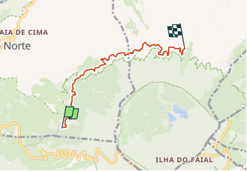

20 km | 30 km-effort


Tous les sentiers balisés d’Europe GUIDE+


Kostenlosegpshiking-Anwendung
 SityTrail
IGN / Geografische Institute
SityTrail World
Die Welt öffnet sich für Sie
Tour Zu Fuß von 5,7 km verfügbar auf Azoren, Unbekannt, Praia do Norte. Diese Tour wird von SityTrail - itinéraires balisés pédestres vorgeschlagen.
Discover the hiking route PRC2FAI Levadas - Praia do Norte. View the map and download the GPS track.
Website: http://trails.visitazores.com/en/trails-azores/faial/levada


Zu Fuß

Wandern
Wandern


sport
sport

Wandern
Wandern