![](/images/other/stat-length.png)
![Tour Zu Fuß Heerlen - Brunssummer Heide Donkergroene route - Photo](https://media.geolcdn.com/t/1900/400/ext.pjpeg?maxdim=2&url=https%3A%2F%2Fmedia.geolcdn.com%2Ff%2Fad778f8c-75f7-4599-b089-d9f2e7b1eaf0.jpeg)
Brunssummer Heide Donkergroene route
SityTrail - itinéraires balisés pédestres
Tous les sentiers balisés d’Europe PRO
![Länge](/images/other/stat-length.png)
Länge
12,6 km
![Maximale Höhe](https://static1.geolcdn.com/siteimages/upload/files/1508320355ic_sort_altitude_max_24dp.png)
Maximale Höhe
169 m
![Positive Höhendifferenz](https://static1.geolcdn.com/siteimages/upload/files/1508320355ic_sort_den_pos_24dp.png)
Positive Höhendifferenz
166 m
![Km-Effort](/images/other/stat-length.png)
Km-Effort
14,8 km
![Min. Höhe](https://static1.geolcdn.com/siteimages/upload/files/1508320355ic_sort_altitude_min_24dp.png)
Min. Höhe
76 m
![Negative Höhendifferenz](https://static1.geolcdn.com/siteimages/upload/files/1508320355ic_sort_den_neg_24dp.png)
Negative Höhendifferenz
164 m
![Boucle](https://static1.geolcdn.com/siteimages/upload/files/16400158638029165_repeat_loop_refresh_sync_direction_icon.png)
Boucle
Ja
Kennzeichnung
Erstellungsdatum :
2022-02-14 14:27:51.03
Letzte Änderung :
2022-02-14 14:27:51.03
![Zu Fuß](https://static1.geolcdn.com/sitytour/trail-icons/100.png)
3h21
Schwierigkeit : Einfach
![Scannen Sie diesen QR-Code, um die Tour in der SityTrail-Anwendung zu öffnen](https://capi.geolives.com/qq0zvz2zws4bq2lad0pu/sitytour/trails/3108659/qr.png?size=200)
Kostenlosegpshiking-Anwendung
Über SityTrail
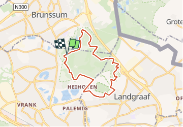
Tour Zu Fuß von 12,6 km verfügbar auf Limburg, Unbekannt, Heerlen. Diese Tour wird von SityTrail - itinéraires balisés pédestres vorgeschlagen.
Beschreibung
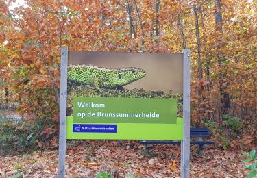
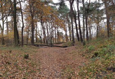
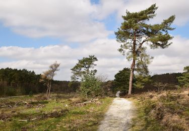
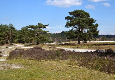
Trail created by Natuurmonumenten.
Symbol: Black pole with green bar just below top
Ort
Land:
Netherlands
Region :
Limburg
Abteilung/Provinz :
Unbekannt
Kommune :
Heerlen
Standort:
Unknown
Gehen Sie:(Dec)
Gehen Sie:(UTM)
709603 ; 5645806 (31U) N.
Kommentare
Touren in der Umgebung
![Tour Wandern Brunssum - 2023-09-02_08h52m12_1055.gpx.xml - Photo](https://media.geolcdn.com/t/375/260/ext.jpg?maxdim=2&url=https%3A%2F%2Fmedia.geolcdn.com%2Ff%2Fa9d4ae47-6d3e-4d55-a221-1cbefb6a45e5.jpg)
![Wandern Wandern](https://static1.geolcdn.com/sitytour/trail-icons/101.png)
2023-09-02_08h52m12_1055.gpx.xml
Wandern
Einfach
(1)
Brunssum,
Limburg,
Unbekannt,
Netherlands
![](/images/other/stat-length.png)
13 km | 15,3 km-effort
3h 29min
![](https://static1.geolcdn.com/siteimages/upload/files/16400158638029165_repeat_loop_refresh_sync_direction_icon.png)
Nein
![Tour Wandern Brunssum - 2021-07-01_12h19m50_1288 - Photo](https://media.geolcdn.com/t/375/260/ext.jpg?maxdim=2&url=https%3A%2F%2Fmedia.geolcdn.com%2Ff%2Fbe5d1686-e005-4060-95f9-6d7688290c56.jpg)
![Wandern Wandern](https://static1.geolcdn.com/sitytour/trail-icons/101.png)
2021-07-01_12h19m50_1288
Wandern
Einfach
(1)
Brunssum,
Limburg,
Unbekannt,
Netherlands
![](/images/other/stat-length.png)
15,1 km | 17,4 km-effort
3h 56min
![](https://static1.geolcdn.com/siteimages/upload/files/16400158638029165_repeat_loop_refresh_sync_direction_icon.png)
Ja
![Tour Wandern Voerendaal - Balade des châteaux - Photo](https://media.geolcdn.com/t/375/260/ext.jpg?maxdim=2&url=https%3A%2F%2Fmedia.geolcdn.com%2Ff%2F429ccad7-a9a0-46f3-9f3b-59ca949a9311.jpg)
![Wandern Wandern](https://static1.geolcdn.com/sitytour/trail-icons/101.png)
Balade des châteaux
Wandern
Sehr leicht
Voerendaal,
Limburg,
Unbekannt,
Netherlands
![](/images/other/stat-length.png)
15 km | 16,3 km-effort
3h 17min
![](https://static1.geolcdn.com/siteimages/upload/files/16400158638029165_repeat_loop_refresh_sync_direction_icon.png)
Ja
![Tour Zu Fuß Voerendaal - De Roode draed - Photo](https://media.geolcdn.com/t/375/260/ext.jpg?maxdim=2&url=https%3A%2F%2Fmedia.geolcdn.com%2Ff%2F929b2282-de58-4d01-9f01-6cd8ac1e114f.jpeg)
![Zu Fuß Zu Fuß](https://static1.geolcdn.com/sitytour/trail-icons/100.png)
De Roode draed
Zu Fuß
Einfach
Voerendaal,
Limburg,
Unbekannt,
Netherlands
![](/images/other/stat-length.png)
10,4 km | 11,3 km-effort
2h 33min
![](https://static1.geolcdn.com/siteimages/upload/files/16400158638029165_repeat_loop_refresh_sync_direction_icon.png)
Ja
![Tour Zu Fuß Heerlen - Terworm Gele route - Photo](https://media.geolcdn.com/t/375/260/ext.jpg?maxdim=2&url=https%3A%2F%2Fmedia.geolcdn.com%2Ff%2F9642298d-dff2-4714-89d7-d2c829819335.jpeg)
![Zu Fuß Zu Fuß](https://static1.geolcdn.com/sitytour/trail-icons/100.png)
Terworm Gele route
Zu Fuß
Einfach
Heerlen,
Limburg,
Unbekannt,
Netherlands
![](/images/other/stat-length.png)
6,3 km | 7,1 km-effort
1h 36min
![](https://static1.geolcdn.com/siteimages/upload/files/16400158638029165_repeat_loop_refresh_sync_direction_icon.png)
Ja
![Tour Zu Fuß Heerlen - Terworm Blauwe route - Photo](https://media.geolcdn.com/t/375/260/ext.jpg?maxdim=2&url=https%3A%2F%2Fmedia.geolcdn.com%2Ff%2F73263b1e-b813-4f2b-9498-f285735de09d.jpeg)
![Zu Fuß Zu Fuß](https://static1.geolcdn.com/sitytour/trail-icons/100.png)
Terworm Blauwe route
Zu Fuß
Einfach
Heerlen,
Limburg,
Unbekannt,
Netherlands
![](/images/other/stat-length.png)
4,1 km | 4,6 km-effort
1h 2min
![](https://static1.geolcdn.com/siteimages/upload/files/16400158638029165_repeat_loop_refresh_sync_direction_icon.png)
Ja
![Tour Zu Fuß Landgraaf - Brunssummer Heide Paarse route - Photo](https://media.geolcdn.com/t/375/260/ext.jpg?maxdim=2&url=https%3A%2F%2Fmedia.geolcdn.com%2Ff%2Ffc5733ac-21b1-4256-9efd-d70ddf8f828f.jpeg)
![Zu Fuß Zu Fuß](https://static1.geolcdn.com/sitytour/trail-icons/100.png)
Brunssummer Heide Paarse route
Zu Fuß
Einfach
Landgraaf,
Limburg,
Unbekannt,
Netherlands
![](/images/other/stat-length.png)
4,7 km | 5,4 km-effort
1h 13min
![](https://static1.geolcdn.com/siteimages/upload/files/16400158638029165_repeat_loop_refresh_sync_direction_icon.png)
Ja
![Tour Zu Fuß Heerlen - Brunssummer Heide Lichtgroene route - Photo](https://media.geolcdn.com/t/375/260/ext.jpg?maxdim=2&url=https%3A%2F%2Fmedia.geolcdn.com%2Ff%2F508b716c-8807-4753-8004-f75de6f128b2.jpeg)
![Zu Fuß Zu Fuß](https://static1.geolcdn.com/sitytour/trail-icons/100.png)
Brunssummer Heide Lichtgroene route
Zu Fuß
Einfach
Heerlen,
Limburg,
Unbekannt,
Netherlands
![](/images/other/stat-length.png)
4,9 km | 5,8 km-effort
1h 19min
![](https://static1.geolcdn.com/siteimages/upload/files/16400158638029165_repeat_loop_refresh_sync_direction_icon.png)
Ja
![Tour Zu Fuß Heerlen - Brunssummer Heide Lichtblauwe route - Photo](https://media.geolcdn.com/t/375/260/ext.jpg?maxdim=2&url=https%3A%2F%2Fmedia.geolcdn.com%2Ff%2F39c8b9d7-66fe-45a6-8073-0f378ccb205b.jpeg)
![Zu Fuß Zu Fuß](https://static1.geolcdn.com/sitytour/trail-icons/100.png)
Brunssummer Heide Lichtblauwe route
Zu Fuß
Einfach
Heerlen,
Limburg,
Unbekannt,
Netherlands
![](/images/other/stat-length.png)
4,5 km | 5,5 km-effort
1h 14min
![](https://static1.geolcdn.com/siteimages/upload/files/16400158638029165_repeat_loop_refresh_sync_direction_icon.png)
Ja