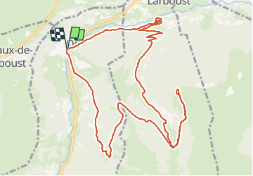
![](/images/other/stat-length.png)
![Tour Wandern Oô - Cap des Arjoulents (finalement pas fait !) & Cabane de Turon - Photo](https://media.geolcdn.com/t/1900/400/e688cf37-bab0-4dc0-a24f-2c09dabc12bc.jpg&format=pjpeg&maxdim=2)
Cap des Arjoulents (finalement pas fait !) & Cabane de Turon
chrisgps
Benutzer
![Länge](/images/other/stat-length.png)
![Maximale Höhe](https://static1.geolcdn.com/siteimages/upload/files/1508320355ic_sort_altitude_max_24dp.png)
![Positive Höhendifferenz](https://static1.geolcdn.com/siteimages/upload/files/1508320355ic_sort_den_pos_24dp.png)
![Km-Effort](/images/other/stat-length.png)
![Min. Höhe](https://static1.geolcdn.com/siteimages/upload/files/1508320355ic_sort_altitude_min_24dp.png)
![Negative Höhendifferenz](https://static1.geolcdn.com/siteimages/upload/files/1508320355ic_sort_den_neg_24dp.png)
![Boucle](https://static1.geolcdn.com/siteimages/upload/files/16400158638029165_repeat_loop_refresh_sync_direction_icon.png)
![Wandern](https://static1.geolcdn.com/sitytour/trail-icons/101.png)
7h03
Schwierigkeit : Einfach
![Scannen Sie diesen QR-Code, um die Tour in der SityTrail-Anwendung zu öffnen](https://capi.geolives.com/qq0zvz2zws4bq2lad0pu/sitytour/trails/3104809/qr.png?size=200)
Kostenlosegpshiking-Anwendung
Über SityTrail
Tour Wandern von 15,4 km verfügbar auf Okzitanien, Haute-Garonne, Oô. Diese Tour wird von chrisgps vorgeschlagen.
Beschreibung
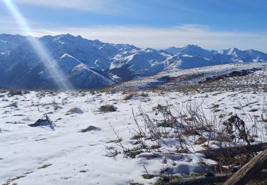
Beau point de vue au Col de la Coume mais ensuite la piste était bien verglacée sur les parties les plus à l'ombre (côté Pardiac) !!!
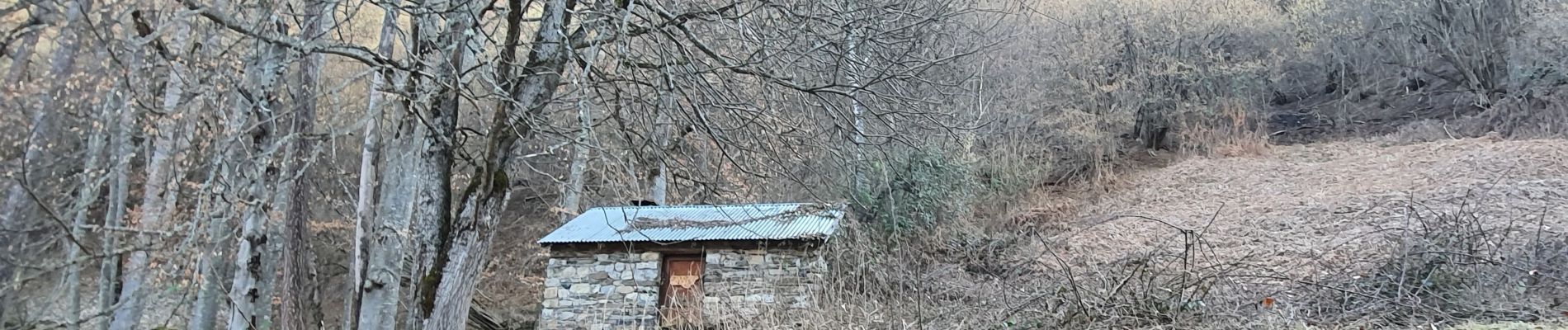
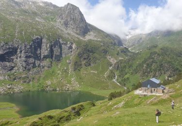
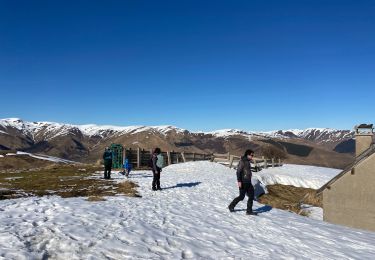
A La cabane de Turon = beau panorama également mais très ventée !!! On a fait une pause plus tranquille à la cabane d'Artigardoune, avant de traverser les jolies granges de Labach.
On a voulu voir le Moulin de Paduran.....mais rien d'exceptionnel ! et on n' pas vu le chemin qui y part en direction de Oô alors on est "remonté" sur celui qu'on voulait "éviter" ! Mais c'est peut-être pas plus mal car il est tout à l'ombre et était sûrement pas agréable à faire.
Belle boucle somme toutes !
Ort
Kommentare
Touren in der Umgebung
![Tour Wandern Portet-de-Luchon - Du Col de Peyresourde au sommet du Pouyaué - Loudervielle - Photo](https://media.geolcdn.com/t/375/260/ext.jpg?maxdim=2&url=https%3A%2F%2Fservices.sitytrail.com%2FGeolivesWS%2FDownloadMedia.ashx%3FTrailID%3D173038%26Media%3D14554_6.jpg)
![Wandern Wandern](https://static1.geolcdn.com/sitytour/trail-icons/101.png)
Wandern
![](/images/other/stat-length.png)
![](https://static1.geolcdn.com/siteimages/upload/files/16400158638029165_repeat_loop_refresh_sync_direction_icon.png)
![Tour Wandern Oô - LUCHON Lac D Oo G3](https://media.geolcdn.com/t/375/260/8f5fd43e-037c-40ed-bcb2-fcca5101f846.jpg&format=jpg&maxdim=2)
![Wandern Wandern](https://static1.geolcdn.com/sitytour/trail-icons/101.png)
Wandern
![](/images/other/stat-length.png)
![](https://static1.geolcdn.com/siteimages/upload/files/16400158638029165_repeat_loop_refresh_sync_direction_icon.png)
![Tour Wandern Saccourvielle - Cap de Salières en boucle depuis Saccourvielle - Photo](https://media.geolcdn.com/t/375/260/9067fbef-09d4-4f17-8717-9e32e9492c01.jpg&format=jpg&maxdim=2)
![Wandern Wandern](https://static1.geolcdn.com/sitytour/trail-icons/101.png)
Wandern
![](/images/other/stat-length.png)
![](https://static1.geolcdn.com/siteimages/upload/files/16400158638029165_repeat_loop_refresh_sync_direction_icon.png)
![Tour Wandern Oô - Seil de la Baque - Photo](https://media.geolcdn.com/t/375/260/ext.jpg?maxdim=2&url=https%3A%2F%2Fstatic1.geolcdn.com%2Fsiteimages%2Fupload%2Ffiles%2F1553511878bg_sport_marche.png)
![Wandern Wandern](https://static1.geolcdn.com/sitytour/trail-icons/101.png)
Wandern
![](/images/other/stat-length.png)
![](https://static1.geolcdn.com/siteimages/upload/files/16400158638029165_repeat_loop_refresh_sync_direction_icon.png)
![Tour Wandern Gouaux-de-Larboust - Boucle autour d’Oô - Photo](https://media.geolcdn.com/t/375/260/c8e9cdf8-0d07-4843-a925-3f7cf6a578dc.jpeg&format=jpg&maxdim=2)
![Wandern Wandern](https://static1.geolcdn.com/sitytour/trail-icons/101.png)
Wandern
![](/images/other/stat-length.png)
![](https://static1.geolcdn.com/siteimages/upload/files/16400158638029165_repeat_loop_refresh_sync_direction_icon.png)
![Tour Wandern Saint-Aventin - Cabane de Courreau en boucle depuis St Aventin - Photo](https://media.geolcdn.com/t/375/260/b7635b43-28f6-485c-bbc3-3b8695853635.jpg&format=jpg&maxdim=2)
![Wandern Wandern](https://static1.geolcdn.com/sitytour/trail-icons/101.png)
Wandern
![](/images/other/stat-length.png)
![](https://static1.geolcdn.com/siteimages/upload/files/16400158638029165_repeat_loop_refresh_sync_direction_icon.png)
![Tour Wandern Oô - Refuge d'Espingo par le lac d'Oô - Photo](https://media.geolcdn.com/t/375/260/e15831e5-28d6-4f8f-ae83-bfddd8590b46.jpg&format=jpg&maxdim=2)
![Wandern Wandern](https://static1.geolcdn.com/sitytour/trail-icons/101.png)
Wandern
![](/images/other/stat-length.png)
![](https://static1.geolcdn.com/siteimages/upload/files/16400158638029165_repeat_loop_refresh_sync_direction_icon.png)
![Tour Wandern Gouaux-de-Larboust - Agudes - Photo](https://media.geolcdn.com/t/375/260/5328ab97-d21f-4799-a96c-329c108ca847.jpg&format=jpg&maxdim=2)
![Wandern Wandern](https://static1.geolcdn.com/sitytour/trail-icons/101.png)
Wandern
![](/images/other/stat-length.png)
![](https://static1.geolcdn.com/siteimages/upload/files/16400158638029165_repeat_loop_refresh_sync_direction_icon.png)
![Tour Zu Fuß Oô - Lac d'Oô et refuge d'Espingo - Photo](https://media.geolcdn.com/t/375/260/ec47e00d-f069-4718-96af-c86e3f3888f1.jpeg&format=jpg&maxdim=2)
![Zu Fuß Zu Fuß](https://static1.geolcdn.com/sitytour/trail-icons/100.png)
Zu Fuß
![](/images/other/stat-length.png)
![](https://static1.geolcdn.com/siteimages/upload/files/16400158638029165_repeat_loop_refresh_sync_direction_icon.png)