![](/images/other/stat-length.png)
![Tour Wandern La Palud-sur-Verdon - Verdon - Sentier du Bastidon A/R (partiel) - Photo](https://media.geolcdn.com/t/1900/400/46507211-4b7a-4b00-96be-37a23b10c0e2.jpg&format=pjpeg&maxdim=2)
Verdon - Sentier du Bastidon A/R (partiel)
fhascoet
Benutzer
![Länge](/images/other/stat-length.png)
Länge
7,2 km
![Maximale Höhe](https://static1.geolcdn.com/siteimages/upload/files/1508320355ic_sort_altitude_max_24dp.png)
Maximale Höhe
827 m
![Positive Höhendifferenz](https://static1.geolcdn.com/siteimages/upload/files/1508320355ic_sort_den_pos_24dp.png)
Positive Höhendifferenz
384 m
![Km-Effort](/images/other/stat-length.png)
Km-Effort
12,4 km
![Min. Höhe](https://static1.geolcdn.com/siteimages/upload/files/1508320355ic_sort_altitude_min_24dp.png)
Min. Höhe
701 m
![Negative Höhendifferenz](https://static1.geolcdn.com/siteimages/upload/files/1508320355ic_sort_den_neg_24dp.png)
Negative Höhendifferenz
390 m
![Boucle](https://static1.geolcdn.com/siteimages/upload/files/16400158638029165_repeat_loop_refresh_sync_direction_icon.png)
Boucle
Ja
Erstellungsdatum :
2022-02-12 11:25:28.983
Letzte Änderung :
2022-02-14 22:06:19.461
![Wandern](https://static1.geolcdn.com/sitytour/trail-icons/101.png)
2h55
Schwierigkeit : Medium
![Scannen Sie diesen QR-Code, um die Tour in der SityTrail-Anwendung zu öffnen](https://capi.geolives.com/qq0zvz2zws4bq2lad0pu/sitytour/trails/3103339/qr.png?size=200)
Kostenlosegpshiking-Anwendung
Über SityTrail
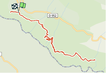
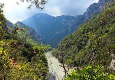
Tour Wandern von 7,2 km verfügbar auf Provence-Alpes-Côte d'Azur, Alpes-de-Haute-Provence, La Palud-sur-Verdon. Diese Tour wird von fhascoet vorgeschlagen.
Beschreibung
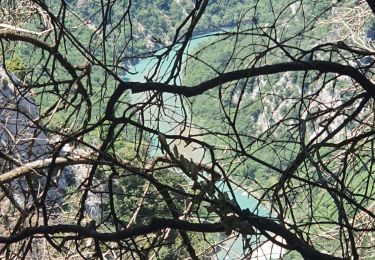
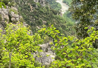
Belle promenade facile en balcon au dessus du Verdon, exposée plein sud.
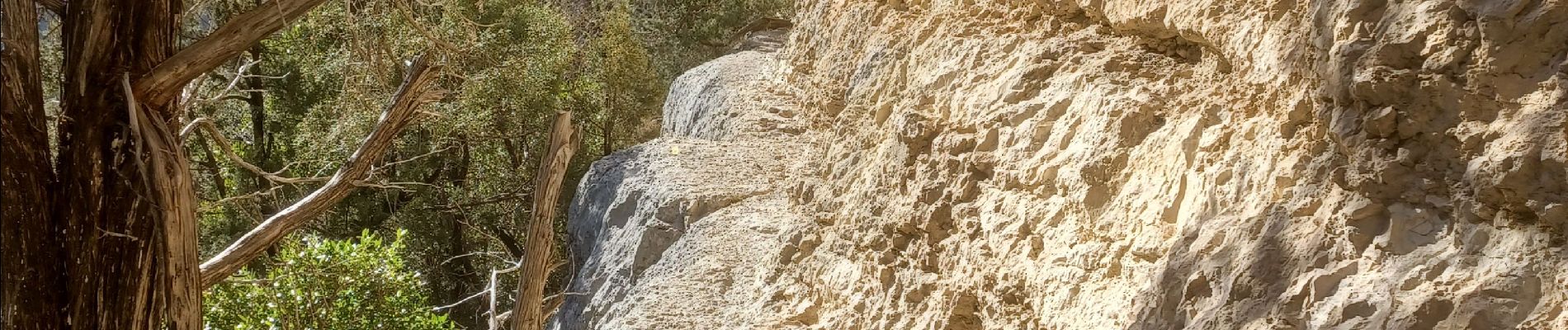
Les passages un peu aériens sont équipés d'une rampe métallique.
Ort
Land:
France
Region :
Provence-Alpes-Côte d'Azur
Abteilung/Provinz :
Alpes-de-Haute-Provence
Kommune :
La Palud-sur-Verdon
Standort:
Unknown
Gehen Sie:(Dec)
Gehen Sie:(UTM)
281281 ; 4850589 (32T) N.
Kommentare
Touren in der Umgebung
![Tour Wandern Aiguines - Verdon - Aiguines - Mont Margès - Photo](https://media.geolcdn.com/t/375/260/ext.jpg?maxdim=2&url=https%3A%2F%2Fstatic1.geolcdn.com%2Fsiteimages%2Fupload%2Ffiles%2F1553511878bg_sport_marche.png)
![Wandern Wandern](https://static1.geolcdn.com/sitytour/trail-icons/101.png)
Verdon - Aiguines - Mont Margès
Wandern
Medium
(1)
Aiguines,
Provence-Alpes-Côte d'Azur,
Var,
France
![](/images/other/stat-length.png)
16,8 km | 31 km-effort
6h 7min
![](https://static1.geolcdn.com/siteimages/upload/files/16400158638029165_repeat_loop_refresh_sync_direction_icon.png)
Ja
![Tour Wandern Aiguines - 25-07-2023 Le Grand Margès retour par le cirque de Vaumale - Photo](https://media.geolcdn.com/t/375/260/636d8cc5-7aa8-4cca-9c55-e40a8cd11367.jpg&format=jpg&maxdim=2)
![Wandern Wandern](https://static1.geolcdn.com/sitytour/trail-icons/101.png)
25-07-2023 Le Grand Margès retour par le cirque de Vaumale
Wandern
Sehr schwierig
Aiguines,
Provence-Alpes-Côte d'Azur,
Var,
France
![](/images/other/stat-length.png)
17 km | 31 km-effort
7h 5min
![](https://static1.geolcdn.com/siteimages/upload/files/16400158638029165_repeat_loop_refresh_sync_direction_icon.png)
Ja
![Tour Wandern Aiguines - Grand Marges Gorges Verdon réel - Photo](https://media.geolcdn.com/t/375/260/a9c9c5a2-d843-460d-8768-728b79cb705c.jpg&format=jpg&maxdim=2)
![Wandern Wandern](https://static1.geolcdn.com/sitytour/trail-icons/101.png)
Grand Marges Gorges Verdon réel
Wandern
Sehr schwierig
Aiguines,
Provence-Alpes-Côte d'Azur,
Var,
France
![](/images/other/stat-length.png)
18 km | 32 km-effort
5h 48min
![](https://static1.geolcdn.com/siteimages/upload/files/16400158638029165_repeat_loop_refresh_sync_direction_icon.png)
Ja
![Tour Wandern Moustiers-Sainte-Marie - 2023-02-14 Les grottes de Saint Maurin - Photo](https://media.geolcdn.com/t/375/260/ff240215-b004-40c4-b632-ab00d837cb62.jpg&format=jpg&maxdim=2)
![Wandern Wandern](https://static1.geolcdn.com/sitytour/trail-icons/101.png)
2023-02-14 Les grottes de Saint Maurin
Wandern
Einfach
Moustiers-Sainte-Marie,
Provence-Alpes-Côte d'Azur,
Alpes-de-Haute-Provence,
France
![](/images/other/stat-length.png)
7,5 km | 12,2 km-effort
4h 11min
![](https://static1.geolcdn.com/siteimages/upload/files/16400158638029165_repeat_loop_refresh_sync_direction_icon.png)
Ja
![Tour Wandern La Palud-sur-Verdon - Gorges du Verdon - La-Palud-sur-Verdon - Tour de la cime de Barbin - Photo](https://media.geolcdn.com/t/375/260/ext.jpg?maxdim=2&url=https%3A%2F%2Fservices.sitytrail.com%2FGeolivesWS%2FDownloadMedia.ashx%3FTrailID%3D347555%26Media%3Dfix__20140922141538.jpg)
![Wandern Wandern](https://static1.geolcdn.com/sitytour/trail-icons/101.png)
Gorges du Verdon - La-Palud-sur-Verdon - Tour de la cime de Barbin
Wandern
Medium
La Palud-sur-Verdon,
Provence-Alpes-Côte d'Azur,
Alpes-de-Haute-Provence,
France
![](/images/other/stat-length.png)
13 km | 20 km-effort
4h 15min
![](https://static1.geolcdn.com/siteimages/upload/files/16400158638029165_repeat_loop_refresh_sync_direction_icon.png)
Ja
![Tour Wandern La Palud-sur-Verdon - Gorges du Verdon - Sentiers des pêcheurs - Photo](https://media.geolcdn.com/t/375/260/ext.jpg?maxdim=2&url=https%3A%2F%2Fservices.sitytrail.com%2FGeolivesWS%2FDownloadMedia.ashx%3FTrailID%3D346084%26Media%3Dfix__20140916112755.jpg)
![Wandern Wandern](https://static1.geolcdn.com/sitytour/trail-icons/101.png)
Gorges du Verdon - Sentiers des pêcheurs
Wandern
Medium
La Palud-sur-Verdon,
Provence-Alpes-Côte d'Azur,
Alpes-de-Haute-Provence,
France
![](/images/other/stat-length.png)
7,5 km | 12,7 km-effort
2h 45min
![](https://static1.geolcdn.com/siteimages/upload/files/16400158638029165_repeat_loop_refresh_sync_direction_icon.png)
Ja
![Tour Wandern La Palud-sur-Verdon - bastidon - Photo](https://media.geolcdn.com/t/375/260/ext.jpg?maxdim=2&url=https%3A%2F%2Fstatic1.geolcdn.com%2Fsiteimages%2Fupload%2Ffiles%2F1553511878bg_sport_marche.png)
![Wandern Wandern](https://static1.geolcdn.com/sitytour/trail-icons/101.png)
bastidon
Wandern
Medium
(1)
La Palud-sur-Verdon,
Provence-Alpes-Côte d'Azur,
Alpes-de-Haute-Provence,
France
![](/images/other/stat-length.png)
18,4 km | 33 km-effort
Unbekannt
![](https://static1.geolcdn.com/siteimages/upload/files/16400158638029165_repeat_loop_refresh_sync_direction_icon.png)
Ja
![Tour Wandern La Palud-sur-Verdon - Sentier des Pêcheurs - Photo](https://media.geolcdn.com/t/375/260/ext.jpg?maxdim=2&url=https%3A%2F%2Fstatic1.geolcdn.com%2Fsiteimages%2Fupload%2Ffiles%2F1553511878bg_sport_marche.png)
![Wandern Wandern](https://static1.geolcdn.com/sitytour/trail-icons/101.png)
Sentier des Pêcheurs
Wandern
Einfach
(2)
La Palud-sur-Verdon,
Provence-Alpes-Côte d'Azur,
Alpes-de-Haute-Provence,
France
![](/images/other/stat-length.png)
5,8 km | 10,3 km-effort
2h 30min
![](https://static1.geolcdn.com/siteimages/upload/files/16400158638029165_repeat_loop_refresh_sync_direction_icon.png)
Ja
![Tour Wandern Aiguines - aiguines - Photo](https://media.geolcdn.com/t/375/260/ext.jpg?maxdim=2&url=https%3A%2F%2Fstatic1.geolcdn.com%2Fsiteimages%2Fupload%2Ffiles%2F1553511878bg_sport_marche.png)
![Wandern Wandern](https://static1.geolcdn.com/sitytour/trail-icons/101.png)
aiguines
Wandern
Sehr leicht
(2)
Aiguines,
Provence-Alpes-Côte d'Azur,
Var,
France
![](/images/other/stat-length.png)
6,6 km | 10,8 km-effort
2h 35min
![](https://static1.geolcdn.com/siteimages/upload/files/16400158638029165_repeat_loop_refresh_sync_direction_icon.png)
Ja