![](/images/other/stat-length.png)
![Tour Zu Fuß Winkel (Eifel) - HeimatSpur Apolloniaweg - Photo](https://media.geolcdn.com/t/1900/400/ext.pjpeg?maxdim=2&url=https%3A%2F%2Fstatic1.geolcdn.com%2Fsiteimages%2Fupload%2Ffiles%2F1545311037marcheuse_200dpi.jpg)
HeimatSpur Apolloniaweg
SityTrail - itinéraires balisés pédestres
Tous les sentiers balisés d’Europe GUIDE+
![Länge](/images/other/stat-length.png)
Länge
13,9 km
![Maximale Höhe](https://static1.geolcdn.com/siteimages/upload/files/1508320355ic_sort_altitude_max_24dp.png)
Maximale Höhe
499 m
![Positive Höhendifferenz](https://static1.geolcdn.com/siteimages/upload/files/1508320355ic_sort_den_pos_24dp.png)
Positive Höhendifferenz
335 m
![Km-Effort](/images/other/stat-length.png)
Km-Effort
18,3 km
![Min. Höhe](https://static1.geolcdn.com/siteimages/upload/files/1508320355ic_sort_altitude_min_24dp.png)
Min. Höhe
351 m
![Negative Höhendifferenz](https://static1.geolcdn.com/siteimages/upload/files/1508320355ic_sort_den_neg_24dp.png)
Negative Höhendifferenz
334 m
![Boucle](https://static1.geolcdn.com/siteimages/upload/files/16400158638029165_repeat_loop_refresh_sync_direction_icon.png)
Boucle
Ja
Kennzeichnung
Erstellungsdatum :
2022-02-11 20:53:40.731
Letzte Änderung :
2022-02-11 20:53:40.731
![Zu Fuß](https://static1.geolcdn.com/sitytour/trail-icons/100.png)
4h10
Schwierigkeit : Einfach
![Scannen Sie diesen QR-Code, um die Tour in der SityTrail-Anwendung zu öffnen](https://capi.geolives.com/qq0zvz2zws4bq2lad0pu/sitytour/trails/3102306/qr.png?size=200)
Kostenlosegpshiking-Anwendung
Über SityTrail
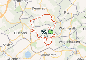
Tour Zu Fuß von 13,9 km verfügbar auf Rheinland-Pfalz, Landkreis Vulkaneifel, Winkel (Eifel). Diese Tour wird von SityTrail - itinéraires balisés pédestres vorgeschlagen.
Beschreibung
Trail created by Eifel Tourismus.
Symbol: grünes rechteck mit AP in weißer Schrift
Ort
Land:
Germany
Region :
Rheinland-Pfalz
Abteilung/Provinz :
Landkreis Vulkaneifel
Kommune :
Winkel (Eifel)
Standort:
Unknown
Gehen Sie:(Dec)
Gehen Sie:(UTM)
353798 ; 5556988 (32U) N.
Kommentare
Touren in der Umgebung
![Tour Zu Fuß Steineberg - HeimatSpur Keltenrundweg - Photo](https://media.geolcdn.com/t/375/260/4b1692aa-f11b-4d67-8202-607607da5a44.jpeg&format=jpg&maxdim=2)
![Zu Fuß Zu Fuß](https://static1.geolcdn.com/sitytour/trail-icons/100.png)
HeimatSpur Keltenrundweg
Zu Fuß
Medium
Steineberg,
Rheinland-Pfalz,
Landkreis Vulkaneifel,
Germany
![](/images/other/stat-length.png)
15,4 km | 20 km-effort
4h 36min
![](https://static1.geolcdn.com/siteimages/upload/files/16400158638029165_repeat_loop_refresh_sync_direction_icon.png)
Ja
![Tour Zu Fuß Strohn - Rundweg Strohner Schweiz - Photo](https://media.geolcdn.com/t/375/260/0d85f9aa-8c27-4f78-b3f2-bfe04930aefe.jpeg&format=jpg&maxdim=2)
![Zu Fuß Zu Fuß](https://static1.geolcdn.com/sitytour/trail-icons/100.png)
Rundweg Strohner Schweiz
Zu Fuß
Einfach
Strohn,
Rheinland-Pfalz,
Landkreis Vulkaneifel,
Germany
![](/images/other/stat-length.png)
3,8 km | 4,6 km-effort
1h 2min
![](https://static1.geolcdn.com/siteimages/upload/files/16400158638029165_repeat_loop_refresh_sync_direction_icon.png)
Ja
![Tour Zu Fuß Strohn - HeimatSpur Lavaweg Strohn - Photo](https://media.geolcdn.com/t/375/260/f09be04d-a256-4442-9159-f0968e97baeb.jpeg&format=jpg&maxdim=2)
![Zu Fuß Zu Fuß](https://static1.geolcdn.com/sitytour/trail-icons/100.png)
HeimatSpur Lavaweg Strohn
Zu Fuß
Medium
Strohn,
Rheinland-Pfalz,
Landkreis Vulkaneifel,
Germany
![](/images/other/stat-length.png)
20 km | 25 km-effort
5h 42min
![](https://static1.geolcdn.com/siteimages/upload/files/16400158638029165_repeat_loop_refresh_sync_direction_icon.png)
Ja
![Tour Zu Fuß Ellscheid - HeimatSpur Antoniusweg - Photo](https://media.geolcdn.com/t/375/260/e2ac7d32-3d28-4bd5-b014-b033b8555420.jpeg&format=jpg&maxdim=2)
![Zu Fuß Zu Fuß](https://static1.geolcdn.com/sitytour/trail-icons/100.png)
HeimatSpur Antoniusweg
Zu Fuß
Einfach
Ellscheid,
Rheinland-Pfalz,
Landkreis Vulkaneifel,
Germany
![](/images/other/stat-length.png)
12 km | 15,1 km-effort
3h 25min
![](https://static1.geolcdn.com/siteimages/upload/files/16400158638029165_repeat_loop_refresh_sync_direction_icon.png)
Ja
![Tour Zu Fuß Strohn - Määrchenweg - Photo](https://media.geolcdn.com/t/375/260/f09be04d-a256-4442-9159-f0968e97baeb.jpeg&format=jpg&maxdim=2)
![Zu Fuß Zu Fuß](https://static1.geolcdn.com/sitytour/trail-icons/100.png)
Määrchenweg
Zu Fuß
Einfach
Strohn,
Rheinland-Pfalz,
Landkreis Vulkaneifel,
Germany
![](/images/other/stat-length.png)
7,9 km | 9,5 km-effort
2h 9min
![](https://static1.geolcdn.com/siteimages/upload/files/16400158638029165_repeat_loop_refresh_sync_direction_icon.png)
Ja
![Tour Zu Fuß Alflen - Wacholder Endert Pfad - Photo](https://media.geolcdn.com/t/375/260/c360b7a4-9a5a-4588-a724-d738b0710b62.jpeg&format=jpg&maxdim=2)
![Zu Fuß Zu Fuß](https://static1.geolcdn.com/sitytour/trail-icons/100.png)
Wacholder Endert Pfad
Zu Fuß
Einfach
Alflen,
Rheinland-Pfalz,
Landkreis Cochem-Zell,
Germany
![](/images/other/stat-length.png)
10,1 km | 12,9 km-effort
2h 56min
![](https://static1.geolcdn.com/siteimages/upload/files/16400158638029165_repeat_loop_refresh_sync_direction_icon.png)
Ja
![Tour Wandern Gillenfeld - Gillenfeld - Photo](https://media.geolcdn.com/t/375/260/e6116093-965e-4e2e-be53-a362624c7b28.jpg&format=jpg&maxdim=2)
![Wandern Wandern](https://static1.geolcdn.com/sitytour/trail-icons/101.png)
Gillenfeld
Wandern
Medium
Gillenfeld,
Rheinland-Pfalz,
Landkreis Vulkaneifel,
Germany
![](/images/other/stat-length.png)
12,2 km | 15,1 km-effort
2h 33min
![](https://static1.geolcdn.com/siteimages/upload/files/16400158638029165_repeat_loop_refresh_sync_direction_icon.png)
Ja
![Tour Wandern Gillenfeld - Gillenfeld 02 - Photo](https://media.geolcdn.com/t/375/260/ext.jpg?maxdim=2&url=https%3A%2F%2Fstatic1.geolcdn.com%2Fsiteimages%2Fupload%2Ffiles%2F1553511878bg_sport_marche.png)
![Wandern Wandern](https://static1.geolcdn.com/sitytour/trail-icons/101.png)
Gillenfeld 02
Wandern
Einfach
Gillenfeld,
Rheinland-Pfalz,
Landkreis Vulkaneifel,
Germany
![](/images/other/stat-length.png)
6 km | 7,5 km-effort
1h 18min
![](https://static1.geolcdn.com/siteimages/upload/files/16400158638029165_repeat_loop_refresh_sync_direction_icon.png)
Ja
![Tour Motor Lutzerath - a-duitsland-de-eifel-1000-bochten-route - Photo](https://media.geolcdn.com/t/375/260/ext.jpg?maxdim=2&url=https%3A%2F%2Fstatic1.geolcdn.com%2Fsiteimages%2Fupload%2Ffiles%2F15247431544x4.jpg)
![Motor Motor](https://static1.geolcdn.com/sitytour/trail-icons/400.png)
a-duitsland-de-eifel-1000-bochten-route
Motor
Sehr leicht
Lutzerath,
Rheinland-Pfalz,
Landkreis Cochem-Zell,
Germany
![](/images/other/stat-length.png)
189 km | 290 km-effort
Unbekannt
![](https://static1.geolcdn.com/siteimages/upload/files/16400158638029165_repeat_loop_refresh_sync_direction_icon.png)
Ja