![](/images/other/stat-length.png)
![Tour Zu Fuß Oelde - Pflaumenwanderweg - Photo](https://media.geolcdn.com/t/1900/400/ext.pjpeg?maxdim=2&url=https%3A%2F%2Fmedia.geolcdn.com%2Ff%2F45d54f1e-a9d3-4af2-8066-e3eeb72c2dd9.jpeg)
Pflaumenwanderweg
SityTrail - itinéraires balisés pédestres
Tous les sentiers balisés d’Europe PRO
![Länge](/images/other/stat-length.png)
Länge
10,5 km
![Maximale Höhe](https://static1.geolcdn.com/siteimages/upload/files/1508320355ic_sort_altitude_max_24dp.png)
Maximale Höhe
155 m
![Positive Höhendifferenz](https://static1.geolcdn.com/siteimages/upload/files/1508320355ic_sort_den_pos_24dp.png)
Positive Höhendifferenz
141 m
![Km-Effort](/images/other/stat-length.png)
Km-Effort
12,4 km
![Min. Höhe](https://static1.geolcdn.com/siteimages/upload/files/1508320355ic_sort_altitude_min_24dp.png)
Min. Höhe
103 m
![Negative Höhendifferenz](https://static1.geolcdn.com/siteimages/upload/files/1508320355ic_sort_den_neg_24dp.png)
Negative Höhendifferenz
141 m
![Boucle](https://static1.geolcdn.com/siteimages/upload/files/16400158638029165_repeat_loop_refresh_sync_direction_icon.png)
Boucle
Ja
Kennzeichnung
Erstellungsdatum :
2022-02-11 20:28:16.401
Letzte Änderung :
2022-02-11 20:28:16.401
![Zu Fuß](https://static1.geolcdn.com/sitytour/trail-icons/100.png)
2h48
Schwierigkeit : Einfach
![Scannen Sie diesen QR-Code, um die Tour in der SityTrail-Anwendung zu öffnen](https://capi.geolives.com/qq0zvz2zws4bq2lad0pu/sitytour/trails/3101852/qr.png?size=200)
Kostenlosegpshiking-Anwendung
Über SityTrail
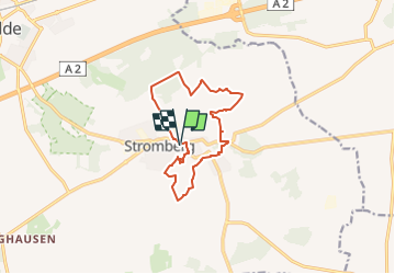
Tour Zu Fuß von 10,5 km verfügbar auf Nordrhein-Westfalen, Kreis Warendorf, Oelde. Diese Tour wird von SityTrail - itinéraires balisés pédestres vorgeschlagen.
Beschreibung
Trail created by Stromberger Pflaume g.U..
Symbol: Weiße Pflaume auf violettem Grund
Website: https://www.stromberger-pflaume.de/wanderweg/
Ort
Land:
Germany
Region :
Nordrhein-Westfalen
Abteilung/Provinz :
Kreis Warendorf
Kommune :
Oelde
Standort:
Unknown
Gehen Sie:(Dec)
Gehen Sie:(UTM)
444993 ; 5739480 (32U) N.
Kommentare
Touren in der Umgebung
![Tour Zu Fuß Verl - Verler Kirchwege - Photo](https://media.geolcdn.com/t/375/260/ext.jpg?maxdim=2&url=https%3A%2F%2Fmedia.geolcdn.com%2Ff%2F02c298a3-0840-4bbf-b00a-bca5e99cf1fb.jpeg)
![Zu Fuß Zu Fuß](https://static1.geolcdn.com/sitytour/trail-icons/100.png)
Verler Kirchwege
Zu Fuß
Einfach
Verl,
Nordrhein-Westfalen,
Kreis Gütersloh,
Germany
![](/images/other/stat-length.png)
7,1 km | 7,6 km-effort
1h 44min
![](https://static1.geolcdn.com/siteimages/upload/files/16400158638029165_repeat_loop_refresh_sync_direction_icon.png)
Nein
![Tour Zu Fuß Harsewinkel - Prälatenweg Marienfeld - Photo](https://media.geolcdn.com/t/375/260/ext.jpg?maxdim=2&url=https%3A%2F%2Fmedia.geolcdn.com%2Ff%2Fd964a764-e262-45bc-8346-81c213467cb9.jpeg)
![Zu Fuß Zu Fuß](https://static1.geolcdn.com/sitytour/trail-icons/100.png)
Prälatenweg Marienfeld
Zu Fuß
Schwierig
Harsewinkel,
Nordrhein-Westfalen,
Kreis Gütersloh,
Germany
![](/images/other/stat-length.png)
31 km | 34 km-effort
7h 43min
![](https://static1.geolcdn.com/siteimages/upload/files/16400158638029165_repeat_loop_refresh_sync_direction_icon.png)
Ja
![Tour Zu Fuß Warendorf - Blaue Runde, ca. 4,5 km - Photo](https://media.geolcdn.com/t/375/260/ext.jpg?maxdim=2&url=https%3A%2F%2Fmedia.geolcdn.com%2Ff%2Fa6a99ae4-36fb-4906-b09e-09983a1e2537.jpeg)
![Zu Fuß Zu Fuß](https://static1.geolcdn.com/sitytour/trail-icons/100.png)
Blaue Runde, ca. 4,5 km
Zu Fuß
Einfach
Warendorf,
Nordrhein-Westfalen,
Kreis Warendorf,
Germany
![](/images/other/stat-length.png)
4,4 km | 4,9 km-effort
1h 6min
![](https://static1.geolcdn.com/siteimages/upload/files/16400158638029165_repeat_loop_refresh_sync_direction_icon.png)
Ja
![Tour Zu Fuß Oelde - Großer Rundweg Geisterholz - Photo](https://media.geolcdn.com/t/375/260/ext.jpg?maxdim=2&url=https%3A%2F%2Fmedia.geolcdn.com%2Ff%2F378638ed-c635-4702-aad4-18c46603a9e6.jpeg)
![Zu Fuß Zu Fuß](https://static1.geolcdn.com/sitytour/trail-icons/100.png)
Großer Rundweg Geisterholz
Zu Fuß
Einfach
Oelde,
Nordrhein-Westfalen,
Kreis Warendorf,
Germany
![](/images/other/stat-length.png)
7,4 km | 8,4 km-effort
1h 54min
![](https://static1.geolcdn.com/siteimages/upload/files/16400158638029165_repeat_loop_refresh_sync_direction_icon.png)
Ja
![Tour Zu Fuß Oelde - Raute Kerkherrenweg - Photo](https://media.geolcdn.com/t/375/260/ext.jpg?maxdim=2&url=https%3A%2F%2Fmedia.geolcdn.com%2Ff%2Fead93180-9d0d-458a-a304-bb5450dff9c0.jpeg)
![Zu Fuß Zu Fuß](https://static1.geolcdn.com/sitytour/trail-icons/100.png)
Raute Kerkherrenweg
Zu Fuß
Einfach
Oelde,
Nordrhein-Westfalen,
Kreis Warendorf,
Germany
![](/images/other/stat-length.png)
3,5 km | 4 km-effort
53min
![](https://static1.geolcdn.com/siteimages/upload/files/16400158638029165_repeat_loop_refresh_sync_direction_icon.png)
Nein
![Tour Zu Fuß Unbekannt - A2 - Brackwede - Photo](https://media.geolcdn.com/t/375/260/ext.jpg?maxdim=2&url=https%3A%2F%2Fmedia.geolcdn.com%2Ff%2F496cfd8d-58e8-4d76-9af5-34dea688c1e8.jpeg)
![Zu Fuß Zu Fuß](https://static1.geolcdn.com/sitytour/trail-icons/100.png)
A2 - Brackwede
Zu Fuß
Einfach
Unbekannt,
Nordrhein-Westfalen,
Bielefeld,
Germany
![](/images/other/stat-length.png)
5,8 km | 6,5 km-effort
1h 28min
![](https://static1.geolcdn.com/siteimages/upload/files/16400158638029165_repeat_loop_refresh_sync_direction_icon.png)
Ja
![Tour Zu Fuß Wadersloh - Liesborn Wanderweg W1 - Photo](https://media.geolcdn.com/t/375/260/ext.jpg?maxdim=2&url=https%3A%2F%2Fstatic1.geolcdn.com%2Fsiteimages%2Fupload%2Ffiles%2F1545311037marcheuse_200dpi.jpg)
![Zu Fuß Zu Fuß](https://static1.geolcdn.com/sitytour/trail-icons/100.png)
Liesborn Wanderweg W1
Zu Fuß
Einfach
Wadersloh,
Nordrhein-Westfalen,
Kreis Warendorf,
Germany
![](/images/other/stat-length.png)
4,6 km | 4,9 km-effort
1h 7min
![](https://static1.geolcdn.com/siteimages/upload/files/16400158638029165_repeat_loop_refresh_sync_direction_icon.png)
Nein
![Tour Wandern Geseke - Geseke - Westereiden - Photo](https://media.geolcdn.com/t/375/260/ext.jpg?maxdim=2&url=https%3A%2F%2Fstatic1.geolcdn.com%2Fsiteimages%2Fupload%2Ffiles%2F1553511878bg_sport_marche.png)
![Wandern Wandern](https://static1.geolcdn.com/sitytour/trail-icons/101.png)
Geseke - Westereiden
Wandern
Medium
Geseke,
Nordrhein-Westfalen,
Kreis Soest,
Germany
![](/images/other/stat-length.png)
15,7 km | 18 km-effort
3h 59min
![](https://static1.geolcdn.com/siteimages/upload/files/16400158638029165_repeat_loop_refresh_sync_direction_icon.png)
Nein