![](/images/other/stat-length.png)
![Tour Zu Fuß Stürzelbronn - Entdeckungsroute Landschaft über Grenzen #4 - Photo](https://media.geolcdn.com/t/1900/400/b188a248-72df-4f8e-bd10-4b2aaba84331.jpeg&format=pjpeg&maxdim=2)
Entdeckungsroute Landschaft über Grenzen #4
SityTrail - itinéraires balisés pédestres
Tous les sentiers balisés d’Europe GUIDE+
![Länge](/images/other/stat-length.png)
![Maximale Höhe](https://static1.geolcdn.com/siteimages/upload/files/1508320355ic_sort_altitude_max_24dp.png)
![Positive Höhendifferenz](https://static1.geolcdn.com/siteimages/upload/files/1508320355ic_sort_den_pos_24dp.png)
![Km-Effort](/images/other/stat-length.png)
![Min. Höhe](https://static1.geolcdn.com/siteimages/upload/files/1508320355ic_sort_altitude_min_24dp.png)
![Negative Höhendifferenz](https://static1.geolcdn.com/siteimages/upload/files/1508320355ic_sort_den_neg_24dp.png)
![Boucle](https://static1.geolcdn.com/siteimages/upload/files/16400158638029165_repeat_loop_refresh_sync_direction_icon.png)
![Zu Fuß](https://static1.geolcdn.com/sitytour/trail-icons/100.png)
5h46
Schwierigkeit : Medium
![Scannen Sie diesen QR-Code, um die Tour in der SityTrail-Anwendung zu öffnen](https://capi.geolives.com/qq0zvz2zws4bq2lad0pu/sitytour/trails/3100784/qr.png?size=200)
Kostenlosegpshiking-Anwendung
Über SityTrail
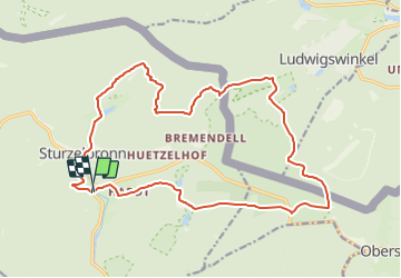
Tour Zu Fuß von 19,1 km verfügbar auf Großer Osten, Mosel, Stürzelbronn. Diese Tour wird von SityTrail - itinéraires balisés pédestres vorgeschlagen.
Beschreibung
Trail created by Club vosgien Niederbronn Reichshoffen.
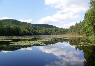
Follows the GR 532 from the Lutzelhardt Castle to the Neuweiher forester's house.
Symbol: green circle with white dot in the middle
Website: https://ignrando.fr/fr/parcours/33728-3713et-niederbronn-4-anneau-vert-sturzelbronn-muehlenbach-roesselquelle-lutzelhardt-welschkobert-obersteinbach
Ort
Kommentare
Touren in der Umgebung
![Tour Wandern Egelshardt - Notre Dame des Bois - Photo](https://media.geolcdn.com/t/375/260/3cf87b27-a59c-4ea6-a7bf-d652826f7266.jpg&format=jpg&maxdim=2)
![Wandern Wandern](https://static1.geolcdn.com/sitytour/trail-icons/101.png)
Wandern
![](/images/other/stat-length.png)
![](https://static1.geolcdn.com/siteimages/upload/files/16400158638029165_repeat_loop_refresh_sync_direction_icon.png)
![Tour Wandern Philippsburg - Les 3 châteaux : Falkenstein, Rothenbourg, Waldeck - Photo](https://media.geolcdn.com/t/375/260/ext.jpg?maxdim=2&url=https%3A%2F%2Fservices.sitytrail.com%2FGeolivesWS%2FDownloadMedia.ashx%3FTrailID%3D118668%26Media%3D12831_5.jpg)
![Wandern Wandern](https://static1.geolcdn.com/sitytour/trail-icons/101.png)
Wandern
![](/images/other/stat-length.png)
![](https://static1.geolcdn.com/siteimages/upload/files/16400158638029165_repeat_loop_refresh_sync_direction_icon.png)
![Tour Zu Fuß Stürzelbronn - Bei den Möchen von Sturzelbronn - Photo](https://media.geolcdn.com/t/375/260/caf7594f-14b2-48e2-8398-22008e31622f.jpeg&format=jpg&maxdim=2)
![Zu Fuß Zu Fuß](https://static1.geolcdn.com/sitytour/trail-icons/100.png)
Zu Fuß
![](/images/other/stat-length.png)
![](https://static1.geolcdn.com/siteimages/upload/files/16400158638029165_repeat_loop_refresh_sync_direction_icon.png)
![Tour Zu Fuß Stürzelbronn - Entdeckungsroute Landschaft über Grenzen #3 - Photo](https://media.geolcdn.com/t/375/260/9a7ba633-a867-49a1-a146-4bd2e867222a.jpeg&format=jpg&maxdim=2)
![Zu Fuß Zu Fuß](https://static1.geolcdn.com/sitytour/trail-icons/100.png)
Zu Fuß
![](/images/other/stat-length.png)
![](https://static1.geolcdn.com/siteimages/upload/files/16400158638029165_repeat_loop_refresh_sync_direction_icon.png)
![Tour Zu Fuß Philippsburg - Blauer Punkt - Photo](https://media.geolcdn.com/t/375/260/405334b8-fc9f-4697-8248-e0a1e7aa1239.jpeg&format=jpg&maxdim=2)
![Zu Fuß Zu Fuß](https://static1.geolcdn.com/sitytour/trail-icons/100.png)
Zu Fuß
![](/images/other/stat-length.png)
![](https://static1.geolcdn.com/siteimages/upload/files/16400158638029165_repeat_loop_refresh_sync_direction_icon.png)
![Tour Zu Fuß Philippsburg - Blaues Dreieck - Photo](https://media.geolcdn.com/t/375/260/7c4d1ef6-26c5-437b-8677-c479e1587290.jpeg&format=jpg&maxdim=2)
![Zu Fuß Zu Fuß](https://static1.geolcdn.com/sitytour/trail-icons/100.png)
Zu Fuß
![](/images/other/stat-length.png)
![](https://static1.geolcdn.com/siteimages/upload/files/16400158638029165_repeat_loop_refresh_sync_direction_icon.png)
![Tour Zu Fuß Philippsburg - Rundwanderweg Burg Falkenstein - Photo](https://media.geolcdn.com/t/375/260/e91548a5-e7ba-4191-adba-ea86f7308a2a.jpeg&format=jpg&maxdim=2)
![Zu Fuß Zu Fuß](https://static1.geolcdn.com/sitytour/trail-icons/100.png)
Zu Fuß
![](/images/other/stat-length.png)
![](https://static1.geolcdn.com/siteimages/upload/files/16400158638029165_repeat_loop_refresh_sync_direction_icon.png)
![Tour Zu Fuß Philippsburg - Großer Rundwanderweg Hanauer Weiher - Photo](https://media.geolcdn.com/t/375/260/d624b80a-e0db-49f0-8afa-1324dc1ccb64.jpeg&format=jpg&maxdim=2)
![Zu Fuß Zu Fuß](https://static1.geolcdn.com/sitytour/trail-icons/100.png)
Zu Fuß
![](/images/other/stat-length.png)
![](https://static1.geolcdn.com/siteimages/upload/files/16400158638029165_repeat_loop_refresh_sync_direction_icon.png)
![Tour Zu Fuß Philippsburg - Mittlerer Rundwanderweg Hanauer Weiher - Photo](https://media.geolcdn.com/t/375/260/3cabd3cc-9517-48f6-be7b-ba8b98cfdd79.jpeg&format=jpg&maxdim=2)
![Zu Fuß Zu Fuß](https://static1.geolcdn.com/sitytour/trail-icons/100.png)
Zu Fuß
![](/images/other/stat-length.png)
![](https://static1.geolcdn.com/siteimages/upload/files/16400158638029165_repeat_loop_refresh_sync_direction_icon.png)