![](/images/other/stat-length.png)
![Tour Zu Fuß Hofgeismar - Hessenweg 6, Abschnitt Hofgeismar - Sababurg - Photo](https://media.geolcdn.com/t/1900/400/ext.pjpeg?maxdim=2&url=https%3A%2F%2Fmedia.geolcdn.com%2Ff%2F83742371-d9da-4abf-a06a-ceb99285ef73.jpeg)
Hessenweg 6, Abschnitt Hofgeismar - Sababurg
SityTrail - itinéraires balisés pédestres
Tous les sentiers balisés d’Europe PRO
![Länge](/images/other/stat-length.png)
Länge
12,3 km
![Maximale Höhe](https://static1.geolcdn.com/siteimages/upload/files/1508320355ic_sort_altitude_max_24dp.png)
Maximale Höhe
329 m
![Positive Höhendifferenz](https://static1.geolcdn.com/siteimages/upload/files/1508320355ic_sort_den_pos_24dp.png)
Positive Höhendifferenz
275 m
![Km-Effort](/images/other/stat-length.png)
Km-Effort
15,6 km
![Min. Höhe](https://static1.geolcdn.com/siteimages/upload/files/1508320355ic_sort_altitude_min_24dp.png)
Min. Höhe
150 m
![Negative Höhendifferenz](https://static1.geolcdn.com/siteimages/upload/files/1508320355ic_sort_den_neg_24dp.png)
Negative Höhendifferenz
156 m
![Boucle](https://static1.geolcdn.com/siteimages/upload/files/16400158638029165_repeat_loop_refresh_sync_direction_icon.png)
Boucle
Nein
Kennzeichnung
Erstellungsdatum :
2022-02-11 19:28:12.52
Letzte Änderung :
2022-02-11 19:28:12.52
![Zu Fuß](https://static1.geolcdn.com/sitytour/trail-icons/100.png)
3h32
Schwierigkeit : Einfach
![Scannen Sie diesen QR-Code, um die Tour in der SityTrail-Anwendung zu öffnen](https://capi.geolives.com/qq0zvz2zws4bq2lad0pu/sitytour/trails/3100719/qr.png?size=200)
Kostenlosegpshiking-Anwendung
Über SityTrail
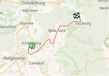
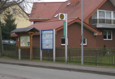
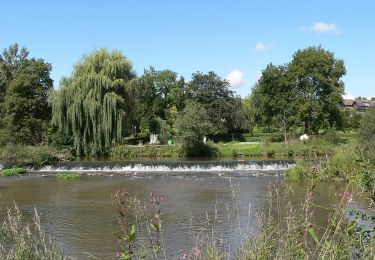
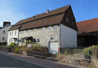
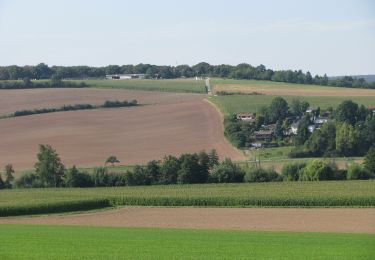
Tour Zu Fuß von 12,3 km verfügbar auf Hessen, Landkreis Kassel, Hofgeismar. Diese Tour wird von SityTrail - itinéraires balisés pédestres vorgeschlagen.
Beschreibung
Trail created by Wanderverband Hessen.
Website: http://www.wanderverband-hessen.de/hessenwege.htm
Ort
Land:
Germany
Region :
Hessen
Abteilung/Provinz :
Landkreis Kassel
Kommune :
Hofgeismar
Standort:
Unknown
Gehen Sie:(Dec)
Gehen Sie:(UTM)
528495 ; 5705848 (32U) N.
Kommentare
Touren in der Umgebung
![Tour Zu Fuß Hofgeismar - Hombressen, Rundweg 5 - Photo](https://media.geolcdn.com/t/375/260/ext.jpg?maxdim=2&url=https%3A%2F%2Fmedia.geolcdn.com%2Ff%2F1d853b7e-c1fb-45b3-94a4-b3d25b15ebf3.jpeg)
![Zu Fuß Zu Fuß](https://static1.geolcdn.com/sitytour/trail-icons/100.png)
Hombressen, Rundweg 5
Zu Fuß
Einfach
Hofgeismar,
Hessen,
Landkreis Kassel,
Germany
![](/images/other/stat-length.png)
4,6 km | 5,9 km-effort
1h 19min
![](https://static1.geolcdn.com/siteimages/upload/files/16400158638029165_repeat_loop_refresh_sync_direction_icon.png)
Ja
![Tour Zu Fuß Hofgeismar - Hombressen, Rundweg 1 - Photo](https://media.geolcdn.com/t/375/260/ext.jpg?maxdim=2&url=https%3A%2F%2Fmedia.geolcdn.com%2Ff%2F19299805-785a-403e-8d92-b33520b8a754.jpeg)
![Zu Fuß Zu Fuß](https://static1.geolcdn.com/sitytour/trail-icons/100.png)
Hombressen, Rundweg 1
Zu Fuß
Einfach
Hofgeismar,
Hessen,
Landkreis Kassel,
Germany
![](/images/other/stat-length.png)
4,2 km | 5,2 km-effort
1h 10min
![](https://static1.geolcdn.com/siteimages/upload/files/16400158638029165_repeat_loop_refresh_sync_direction_icon.png)
Ja
![Tour Zu Fuß Hofgeismar - Hombressen, Rundweg 4 - Photo](https://media.geolcdn.com/t/375/260/ext.jpg?maxdim=2&url=https%3A%2F%2Fmedia.geolcdn.com%2Ff%2F8f0078f4-4861-4b3c-bdcb-7905e5165513.jpeg)
![Zu Fuß Zu Fuß](https://static1.geolcdn.com/sitytour/trail-icons/100.png)
Hombressen, Rundweg 4
Zu Fuß
Einfach
Hofgeismar,
Hessen,
Landkreis Kassel,
Germany
![](/images/other/stat-length.png)
8,4 km | 10 km-effort
2h 15min
![](https://static1.geolcdn.com/siteimages/upload/files/16400158638029165_repeat_loop_refresh_sync_direction_icon.png)
Ja
![Tour Zu Fuß Hofgeismar - Hombressen, Rundweg 4 - alternativ - Photo](https://media.geolcdn.com/t/375/260/ext.jpg?maxdim=2&url=https%3A%2F%2Fmedia.geolcdn.com%2Ff%2F8f0078f4-4861-4b3c-bdcb-7905e5165513.jpeg)
![Zu Fuß Zu Fuß](https://static1.geolcdn.com/sitytour/trail-icons/100.png)
Hombressen, Rundweg 4 - alternativ
Zu Fuß
Einfach
Hofgeismar,
Hessen,
Landkreis Kassel,
Germany
![](/images/other/stat-length.png)
9 km | 11 km-effort
2h 29min
![](https://static1.geolcdn.com/siteimages/upload/files/16400158638029165_repeat_loop_refresh_sync_direction_icon.png)
Ja
![Tour Zu Fuß Trendelburg - Trendelburg - Eberschütz, E2 - Photo](https://media.geolcdn.com/t/375/260/ext.jpg?maxdim=2&url=https%3A%2F%2Fmedia.geolcdn.com%2Ff%2F6aeace3f-11cb-45d2-862a-26dc78858d6e.jpeg)
![Zu Fuß Zu Fuß](https://static1.geolcdn.com/sitytour/trail-icons/100.png)
Trendelburg - Eberschütz, E2
Zu Fuß
Einfach
Trendelburg,
Hessen,
Landkreis Kassel,
Germany
![](/images/other/stat-length.png)
4,4 km | 6 km-effort
1h 22min
![](https://static1.geolcdn.com/siteimages/upload/files/16400158638029165_repeat_loop_refresh_sync_direction_icon.png)
Ja
![Tour Zu Fuß Hofgeismar - Eco Pfad Historische Dorferkundung Hümme - Talrunde - Photo](https://media.geolcdn.com/t/375/260/ext.jpg?maxdim=2&url=https%3A%2F%2Fmedia.geolcdn.com%2Ff%2F440513f8-048f-4a90-a57d-2bfa098c28ba.jpeg)
![Zu Fuß Zu Fuß](https://static1.geolcdn.com/sitytour/trail-icons/100.png)
Eco Pfad Historische Dorferkundung Hümme - Talrunde
Zu Fuß
Einfach
Hofgeismar,
Hessen,
Landkreis Kassel,
Germany
![](/images/other/stat-length.png)
3,3 km | 3,6 km-effort
49min
![](https://static1.geolcdn.com/siteimages/upload/files/16400158638029165_repeat_loop_refresh_sync_direction_icon.png)
Ja
![Tour Zu Fuß Trendelburg - Trendelburg - Eberschütz, E1 - Photo](https://media.geolcdn.com/t/375/260/ext.jpg?maxdim=2&url=https%3A%2F%2Fmedia.geolcdn.com%2Ff%2F6aeace3f-11cb-45d2-862a-26dc78858d6e.jpeg)
![Zu Fuß Zu Fuß](https://static1.geolcdn.com/sitytour/trail-icons/100.png)
Trendelburg - Eberschütz, E1
Zu Fuß
Einfach
Trendelburg,
Hessen,
Landkreis Kassel,
Germany
![](/images/other/stat-length.png)
4,8 km | 6,5 km-effort
1h 28min
![](https://static1.geolcdn.com/siteimages/upload/files/16400158638029165_repeat_loop_refresh_sync_direction_icon.png)
Ja
![Tour Zu Fuß Hofgeismar - Rund um den Schöneberg - Photo](https://media.geolcdn.com/t/375/260/ext.jpg?maxdim=2&url=https%3A%2F%2Fmedia.geolcdn.com%2Ff%2F6db7ffc9-a999-4b4b-96cd-18dd233867c0.jpeg)
![Zu Fuß Zu Fuß](https://static1.geolcdn.com/sitytour/trail-icons/100.png)
Rund um den Schöneberg
Zu Fuß
Einfach
Hofgeismar,
Hessen,
Landkreis Kassel,
Germany
![](/images/other/stat-length.png)
6 km | 8,4 km-effort
1h 55min
![](https://static1.geolcdn.com/siteimages/upload/files/16400158638029165_repeat_loop_refresh_sync_direction_icon.png)
Ja
![Tour Zu Fuß Hofgeismar - Schöneberger Burgruinen-Steig - Photo](https://media.geolcdn.com/t/375/260/ext.jpg?maxdim=2&url=https%3A%2F%2Fmedia.geolcdn.com%2Ff%2F6db7ffc9-a999-4b4b-96cd-18dd233867c0.jpeg)
![Zu Fuß Zu Fuß](https://static1.geolcdn.com/sitytour/trail-icons/100.png)
Schöneberger Burgruinen-Steig
Zu Fuß
Einfach
Hofgeismar,
Hessen,
Landkreis Kassel,
Germany
![](/images/other/stat-length.png)
5,2 km | 7,7 km-effort
1h 45min
![](https://static1.geolcdn.com/siteimages/upload/files/16400158638029165_repeat_loop_refresh_sync_direction_icon.png)
Ja