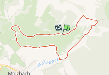
![](/images/other/stat-length.png)
![Tour Zu Fuß Hünfeld - Rundweg am Weinberg - Photo](https://media.geolcdn.com/t/1900/400/a44c4828-02e2-4be5-921e-174e45ad8c6b.jpeg&format=pjpeg&maxdim=2)
Rundweg am Weinberg
SityTrail - itinéraires balisés pédestres
Tous les sentiers balisés d’Europe GUIDE+
![Länge](/images/other/stat-length.png)
Länge
4,8 km
![Maximale Höhe](https://static1.geolcdn.com/siteimages/upload/files/1508320355ic_sort_altitude_max_24dp.png)
Maximale Höhe
426 m
![Positive Höhendifferenz](https://static1.geolcdn.com/siteimages/upload/files/1508320355ic_sort_den_pos_24dp.png)
Positive Höhendifferenz
118 m
![Km-Effort](/images/other/stat-length.png)
Km-Effort
6,3 km
![Min. Höhe](https://static1.geolcdn.com/siteimages/upload/files/1508320355ic_sort_altitude_min_24dp.png)
Min. Höhe
342 m
![Negative Höhendifferenz](https://static1.geolcdn.com/siteimages/upload/files/1508320355ic_sort_den_neg_24dp.png)
Negative Höhendifferenz
114 m
![Boucle](https://static1.geolcdn.com/siteimages/upload/files/16400158638029165_repeat_loop_refresh_sync_direction_icon.png)
Boucle
Ja
Kennzeichnung
Erstellungsdatum :
2022-02-11 19:06:02.595
Letzte Änderung :
2022-02-11 19:06:02.595
![Zu Fuß](https://static1.geolcdn.com/sitytour/trail-icons/100.png)
1h26
Schwierigkeit : Einfach
![Scannen Sie diesen QR-Code, um die Tour in der SityTrail-Anwendung zu öffnen](https://capi.geolives.com/qq0zvz2zws4bq2lad0pu/sitytour/trails/3100253/qr.png?size=200)
Kostenlosegpshiking-Anwendung
Über SityTrail
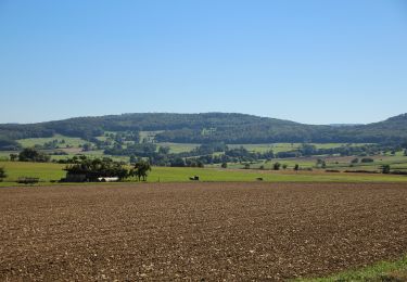
Tour Zu Fuß von 4,8 km verfügbar auf Hessen, Landkreis Fulda, Hünfeld. Diese Tour wird von SityTrail - itinéraires balisés pédestres vorgeschlagen.
Beschreibung
Trail created by Stadt Hünfeld.
Symbol: Braun/Weißes Schild "Naturschutzgebiet Weinberg"
Ort
Land:
Germany
Region :
Hessen
Abteilung/Provinz :
Landkreis Fulda
Kommune :
Hünfeld
Standort:
Unknown
Gehen Sie:(Dec)
Gehen Sie:(UTM)
557500 ; 5613845 (32U) N.
Kommentare
Touren in der Umgebung
![Tour Zu Fuß Hünfeld - DE-5 - Photo](https://media.geolcdn.com/t/375/260/58a0b969-ab86-4a09-918e-be50a833d7d9.jpeg&format=jpg&maxdim=2)
![Zu Fuß Zu Fuß](https://static1.geolcdn.com/sitytour/trail-icons/100.png)
![Tour Zu Fuß Hünfeld - Mackenzell Rundweg Nr. 9 - Photo](https://media.geolcdn.com/t/375/260/54eb07e1-748d-4d6a-b81b-8369574ffba6.jpeg&format=jpg&maxdim=2)
![Zu Fuß Zu Fuß](https://static1.geolcdn.com/sitytour/trail-icons/100.png)
Mackenzell Rundweg Nr. 9
Zu Fuß
Einfach
Hünfeld,
Hessen,
Landkreis Fulda,
Germany
![](/images/other/stat-length.png)
10,1 km | 14,4 km-effort
3h 16min
![](https://static1.geolcdn.com/siteimages/upload/files/16400158638029165_repeat_loop_refresh_sync_direction_icon.png)
Ja
![Tour Zu Fuß Hünfeld - Rundweg 7, Mackenzell - Photo](https://media.geolcdn.com/t/375/260/54eb07e1-748d-4d6a-b81b-8369574ffba6.jpeg&format=jpg&maxdim=2)
![Zu Fuß Zu Fuß](https://static1.geolcdn.com/sitytour/trail-icons/100.png)
Rundweg 7, Mackenzell
Zu Fuß
Einfach
Hünfeld,
Hessen,
Landkreis Fulda,
Germany
![](/images/other/stat-length.png)
5,9 km | 8,3 km-effort
1h 52min
![](https://static1.geolcdn.com/siteimages/upload/files/16400158638029165_repeat_loop_refresh_sync_direction_icon.png)
Nein
![Tour Zu Fuß Hünfeld - Hünfeld - Burgruine Hauneck - Photo](https://media.geolcdn.com/t/375/260/ext.jpg?maxdim=2&url=https%3A%2F%2Fstatic1.geolcdn.com%2Fsiteimages%2Fupload%2Ffiles%2F1545311037marcheuse_200dpi.jpg)
![Zu Fuß Zu Fuß](https://static1.geolcdn.com/sitytour/trail-icons/100.png)
Hünfeld - Burgruine Hauneck
Zu Fuß
Einfach
Hünfeld,
Hessen,
Landkreis Fulda,
Germany
![](/images/other/stat-length.png)
7,7 km | 9 km-effort
2h 3min
![](https://static1.geolcdn.com/siteimages/upload/files/16400158638029165_repeat_loop_refresh_sync_direction_icon.png)
Nein
![Tour Zu Fuß Nüsttal - Rundweg 2, Haselstein - Photo](https://media.geolcdn.com/t/375/260/ebe04403-ddd9-42f4-83a7-f7841c87ee31.jpeg&format=jpg&maxdim=2)
![Zu Fuß Zu Fuß](https://static1.geolcdn.com/sitytour/trail-icons/100.png)
Rundweg 2, Haselstein
Zu Fuß
Einfach
Nüsttal,
Hessen,
Landkreis Fulda,
Germany
![](/images/other/stat-length.png)
10,1 km | 13,8 km-effort
3h 8min
![](https://static1.geolcdn.com/siteimages/upload/files/16400158638029165_repeat_loop_refresh_sync_direction_icon.png)
Ja