


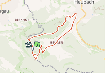

6,3 km | 9,3 km-effort

Tous les sentiers balisés d’Europe GUIDE+


Kostenlosegpshiking-Anwendung
 SityTrail
IGN / Geografische Institute
SityTrail World
Die Welt öffnet sich für Sie
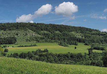
Tour Zu Fuß von 7,4 km verfügbar auf Baden-Württemberg, Landkreis Reutlingen, Gomadingen. Diese Tour wird von SityTrail - itinéraires balisés pédestres vorgeschlagen.
Trail created by Stadt Heubach.
Symbol: WEG 2
 "
data-pinterest-text="Pin it"
data-tweet-text="share on twitter"
data-facebook-share-url="https://www.sitytrail.com/de/trails/3100142-gomadingen--heubach-wanderweg-2-xdie-idyllischex/?photo=1#lg=1&slide=1"
data-twitter-share-url="https://www.sitytrail.com/de/trails/3100142-gomadingen--heubach-wanderweg-2-xdie-idyllischex/?photo=1#lg=1&slide=1"
data-googleplus-share-url="https://www.sitytrail.com/de/trails/3100142-gomadingen--heubach-wanderweg-2-xdie-idyllischex/?photo=1#lg=1&slide=1"
data-pinterest-share-url="https://www.sitytrail.com/de/trails/3100142-gomadingen--heubach-wanderweg-2-xdie-idyllischex/?photo=1#lg=1&slide=1">
"
data-pinterest-text="Pin it"
data-tweet-text="share on twitter"
data-facebook-share-url="https://www.sitytrail.com/de/trails/3100142-gomadingen--heubach-wanderweg-2-xdie-idyllischex/?photo=1#lg=1&slide=1"
data-twitter-share-url="https://www.sitytrail.com/de/trails/3100142-gomadingen--heubach-wanderweg-2-xdie-idyllischex/?photo=1#lg=1&slide=1"
data-googleplus-share-url="https://www.sitytrail.com/de/trails/3100142-gomadingen--heubach-wanderweg-2-xdie-idyllischex/?photo=1#lg=1&slide=1"
data-pinterest-share-url="https://www.sitytrail.com/de/trails/3100142-gomadingen--heubach-wanderweg-2-xdie-idyllischex/?photo=1#lg=1&slide=1">
 "
data-pinterest-text="Pin it"
data-tweet-text="share on twitter"
data-facebook-share-url="https://www.sitytrail.com/de/trails/3100142-gomadingen--heubach-wanderweg-2-xdie-idyllischex/?photo=2#lg=1&slide=2"
data-twitter-share-url="https://www.sitytrail.com/de/trails/3100142-gomadingen--heubach-wanderweg-2-xdie-idyllischex/?photo=2#lg=1&slide=2"
data-googleplus-share-url="https://www.sitytrail.com/de/trails/3100142-gomadingen--heubach-wanderweg-2-xdie-idyllischex/?photo=2#lg=1&slide=2"
data-pinterest-share-url="https://www.sitytrail.com/de/trails/3100142-gomadingen--heubach-wanderweg-2-xdie-idyllischex/?photo=2#lg=1&slide=2">
"
data-pinterest-text="Pin it"
data-tweet-text="share on twitter"
data-facebook-share-url="https://www.sitytrail.com/de/trails/3100142-gomadingen--heubach-wanderweg-2-xdie-idyllischex/?photo=2#lg=1&slide=2"
data-twitter-share-url="https://www.sitytrail.com/de/trails/3100142-gomadingen--heubach-wanderweg-2-xdie-idyllischex/?photo=2#lg=1&slide=2"
data-googleplus-share-url="https://www.sitytrail.com/de/trails/3100142-gomadingen--heubach-wanderweg-2-xdie-idyllischex/?photo=2#lg=1&slide=2"
data-pinterest-share-url="https://www.sitytrail.com/de/trails/3100142-gomadingen--heubach-wanderweg-2-xdie-idyllischex/?photo=2#lg=1&slide=2">
 "
data-pinterest-text="Pin it"
data-tweet-text="share on twitter"
data-facebook-share-url="https://www.sitytrail.com/de/trails/3100142-gomadingen--heubach-wanderweg-2-xdie-idyllischex/?photo=3#lg=1&slide=3"
data-twitter-share-url="https://www.sitytrail.com/de/trails/3100142-gomadingen--heubach-wanderweg-2-xdie-idyllischex/?photo=3#lg=1&slide=3"
data-googleplus-share-url="https://www.sitytrail.com/de/trails/3100142-gomadingen--heubach-wanderweg-2-xdie-idyllischex/?photo=3#lg=1&slide=3"
data-pinterest-share-url="https://www.sitytrail.com/de/trails/3100142-gomadingen--heubach-wanderweg-2-xdie-idyllischex/?photo=3#lg=1&slide=3">
"
data-pinterest-text="Pin it"
data-tweet-text="share on twitter"
data-facebook-share-url="https://www.sitytrail.com/de/trails/3100142-gomadingen--heubach-wanderweg-2-xdie-idyllischex/?photo=3#lg=1&slide=3"
data-twitter-share-url="https://www.sitytrail.com/de/trails/3100142-gomadingen--heubach-wanderweg-2-xdie-idyllischex/?photo=3#lg=1&slide=3"
data-googleplus-share-url="https://www.sitytrail.com/de/trails/3100142-gomadingen--heubach-wanderweg-2-xdie-idyllischex/?photo=3#lg=1&slide=3"
data-pinterest-share-url="https://www.sitytrail.com/de/trails/3100142-gomadingen--heubach-wanderweg-2-xdie-idyllischex/?photo=3#lg=1&slide=3">
 "
data-pinterest-text="Pin it"
data-tweet-text="share on twitter"
data-facebook-share-url="https://www.sitytrail.com/de/trails/3100142-gomadingen--heubach-wanderweg-2-xdie-idyllischex/?photo=4#lg=1&slide=4"
data-twitter-share-url="https://www.sitytrail.com/de/trails/3100142-gomadingen--heubach-wanderweg-2-xdie-idyllischex/?photo=4#lg=1&slide=4"
data-googleplus-share-url="https://www.sitytrail.com/de/trails/3100142-gomadingen--heubach-wanderweg-2-xdie-idyllischex/?photo=4#lg=1&slide=4"
data-pinterest-share-url="https://www.sitytrail.com/de/trails/3100142-gomadingen--heubach-wanderweg-2-xdie-idyllischex/?photo=4#lg=1&slide=4">
"
data-pinterest-text="Pin it"
data-tweet-text="share on twitter"
data-facebook-share-url="https://www.sitytrail.com/de/trails/3100142-gomadingen--heubach-wanderweg-2-xdie-idyllischex/?photo=4#lg=1&slide=4"
data-twitter-share-url="https://www.sitytrail.com/de/trails/3100142-gomadingen--heubach-wanderweg-2-xdie-idyllischex/?photo=4#lg=1&slide=4"
data-googleplus-share-url="https://www.sitytrail.com/de/trails/3100142-gomadingen--heubach-wanderweg-2-xdie-idyllischex/?photo=4#lg=1&slide=4"
data-pinterest-share-url="https://www.sitytrail.com/de/trails/3100142-gomadingen--heubach-wanderweg-2-xdie-idyllischex/?photo=4#lg=1&slide=4">

Zu Fuß
Zu Fuß
Zu Fuß
Zu Fuß
Zu Fuß
Zu Fuß

Zu Fuß
Zu Fuß
Zu Fuß