![](/images/other/stat-length.png)
![Tour Zu Fuß Motten - Motten - Altenfeld - Photo](https://media.geolcdn.com/t/1900/400/e4b0e809-e63b-41c3-a255-1a5c3235dd5a.jpeg&format=pjpeg&maxdim=2)
Motten - Altenfeld
SityTrail - itinéraires balisés pédestres
Tous les sentiers balisés d’Europe GUIDE+
![Länge](/images/other/stat-length.png)
Länge
13 km
![Maximale Höhe](https://static1.geolcdn.com/siteimages/upload/files/1508320355ic_sort_altitude_max_24dp.png)
Maximale Höhe
685 m
![Positive Höhendifferenz](https://static1.geolcdn.com/siteimages/upload/files/1508320355ic_sort_den_pos_24dp.png)
Positive Höhendifferenz
513 m
![Km-Effort](/images/other/stat-length.png)
Km-Effort
19,2 km
![Min. Höhe](https://static1.geolcdn.com/siteimages/upload/files/1508320355ic_sort_altitude_min_24dp.png)
Min. Höhe
402 m
![Negative Höhendifferenz](https://static1.geolcdn.com/siteimages/upload/files/1508320355ic_sort_den_neg_24dp.png)
Negative Höhendifferenz
306 m
![Boucle](https://static1.geolcdn.com/siteimages/upload/files/16400158638029165_repeat_loop_refresh_sync_direction_icon.png)
Boucle
Nein
Kennzeichnung
Erstellungsdatum :
2022-02-11 17:58:21.888
Letzte Änderung :
2022-02-11 17:58:21.888
![Zu Fuß](https://static1.geolcdn.com/sitytour/trail-icons/100.png)
4h21
Schwierigkeit : Einfach
![Scannen Sie diesen QR-Code, um die Tour in der SityTrail-Anwendung zu öffnen](https://capi.geolives.com/qq0zvz2zws4bq2lad0pu/sitytour/trails/3098848/qr.png?size=200)
Kostenlosegpshiking-Anwendung
Über SityTrail
Tour Zu Fuß von 13 km verfügbar auf Bayern, Landkreis Bad Kissingen, Motten. Diese Tour wird von SityTrail - itinéraires balisés pédestres vorgeschlagen.
Beschreibung
Trail created by Rhönklub.
check name ...
Symbol: Yellow droplet-shaped symbol (rot. 90deg) on white
Ort
Land:
Germany
Region :
Bayern
Abteilung/Provinz :
Landkreis Bad Kissingen
Kommune :
Motten
Standort:
Unknown
Gehen Sie:(Dec)
Gehen Sie:(UTM)
554713 ; 5583146 (32U) N.
Kommentare
Touren in der Umgebung
![Tour Zu Fuß Motten - Der Mottener - Photo](https://media.geolcdn.com/t/375/260/cb184438-c416-4241-9602-9944ddd7ac18.jpeg&format=jpg&maxdim=2)
![Zu Fuß Zu Fuß](https://static1.geolcdn.com/sitytour/trail-icons/100.png)
Der Mottener
Zu Fuß
Einfach
Motten,
Bayern,
Landkreis Bad Kissingen,
Germany
![](/images/other/stat-length.png)
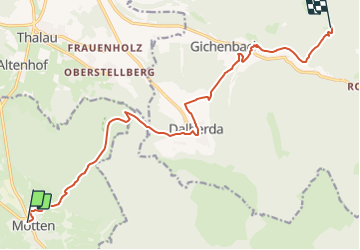
5 km | 6,7 km-effort
1h 31min
![](https://static1.geolcdn.com/siteimages/upload/files/16400158638029165_repeat_loop_refresh_sync_direction_icon.png)
Nein
![Tour Zu Fuß Ebersburg - Rhön-Rundweg 1 Wachholderhuette - Photo](https://media.geolcdn.com/t/375/260/53c7ee77-d2b4-43ef-ac1d-b74b83bcf33e.jpeg&format=jpg&maxdim=2)
![Zu Fuß Zu Fuß](https://static1.geolcdn.com/sitytour/trail-icons/100.png)
Rhön-Rundweg 1 Wachholderhuette
Zu Fuß
Einfach
Ebersburg,
Hessen,
Landkreis Fulda,
Germany
![](/images/other/stat-length.png)
5,7 km | 8,1 km-effort
1h 50min
![](https://static1.geolcdn.com/siteimages/upload/files/16400158638029165_repeat_loop_refresh_sync_direction_icon.png)
Ja
![Tour Zu Fuß Gersfeld - Rhön-Rundweg 3 Dalherda - Photo](https://media.geolcdn.com/t/375/260/508915a8-6988-4c95-b465-c3ee89a15ee6.jpeg&format=jpg&maxdim=2)
![Zu Fuß Zu Fuß](https://static1.geolcdn.com/sitytour/trail-icons/100.png)
Rhön-Rundweg 3 Dalherda
Zu Fuß
Einfach
Gersfeld,
Hessen,
Landkreis Fulda,
Germany
![](/images/other/stat-length.png)
4,2 km | 6 km-effort
1h 21min
![](https://static1.geolcdn.com/siteimages/upload/files/16400158638029165_repeat_loop_refresh_sync_direction_icon.png)
Ja
![Tour Zu Fuß Gersfeld - Rhön-Rundweg 2 Dalherda - Photo](https://media.geolcdn.com/t/375/260/508915a8-6988-4c95-b465-c3ee89a15ee6.jpeg&format=jpg&maxdim=2)
![Zu Fuß Zu Fuß](https://static1.geolcdn.com/sitytour/trail-icons/100.png)
Rhön-Rundweg 2 Dalherda
Zu Fuß
Einfach
Gersfeld,
Hessen,
Landkreis Fulda,
Germany
![](/images/other/stat-length.png)
8,7 km | 11,8 km-effort
2h 40min
![](https://static1.geolcdn.com/siteimages/upload/files/16400158638029165_repeat_loop_refresh_sync_direction_icon.png)
Nein
![Tour Zu Fuß Gersfeld - Rhön-Rundweg 2 Horstberg - Photo](https://media.geolcdn.com/t/375/260/180e4496-d0e2-409e-98f9-c36e2540c0a3.jpeg&format=jpg&maxdim=2)
![Zu Fuß Zu Fuß](https://static1.geolcdn.com/sitytour/trail-icons/100.png)
Rhön-Rundweg 2 Horstberg
Zu Fuß
Einfach
Gersfeld,
Hessen,
Landkreis Fulda,
Germany
![](/images/other/stat-length.png)
4,8 km | 6,6 km-effort
1h 29min
![](https://static1.geolcdn.com/siteimages/upload/files/16400158638029165_repeat_loop_refresh_sync_direction_icon.png)
Ja
![Tour Zu Fuß Motten - Der Mottener - Photo](https://media.geolcdn.com/t/375/260/ext.jpg?maxdim=2&url=https%3A%2F%2Fstatic1.geolcdn.com%2Fsiteimages%2Fupload%2Ffiles%2F1545311037marcheuse_200dpi.jpg)
![Zu Fuß Zu Fuß](https://static1.geolcdn.com/sitytour/trail-icons/100.png)
Der Mottener
Zu Fuß
Einfach
Motten,
Bayern,
Landkreis Bad Kissingen,
Germany
![](/images/other/stat-length.png)
3,8 km | 6,1 km-effort
1h 23min
![](https://static1.geolcdn.com/siteimages/upload/files/16400158638029165_repeat_loop_refresh_sync_direction_icon.png)
Nein
![Tour Zu Fuß Kalbach - Rhön-Rundweg Motten 2 - Photo](https://media.geolcdn.com/t/375/260/ext.jpg?maxdim=2&url=https%3A%2F%2Fstatic1.geolcdn.com%2Fsiteimages%2Fupload%2Ffiles%2F1545311037marcheuse_200dpi.jpg)
![Zu Fuß Zu Fuß](https://static1.geolcdn.com/sitytour/trail-icons/100.png)
Rhön-Rundweg Motten 2
Zu Fuß
Einfach
Kalbach,
Hessen,
Landkreis Fulda,
Germany
![](/images/other/stat-length.png)
3,7 km | 4,8 km-effort
1h 5min
![](https://static1.geolcdn.com/siteimages/upload/files/16400158638029165_repeat_loop_refresh_sync_direction_icon.png)
Nein